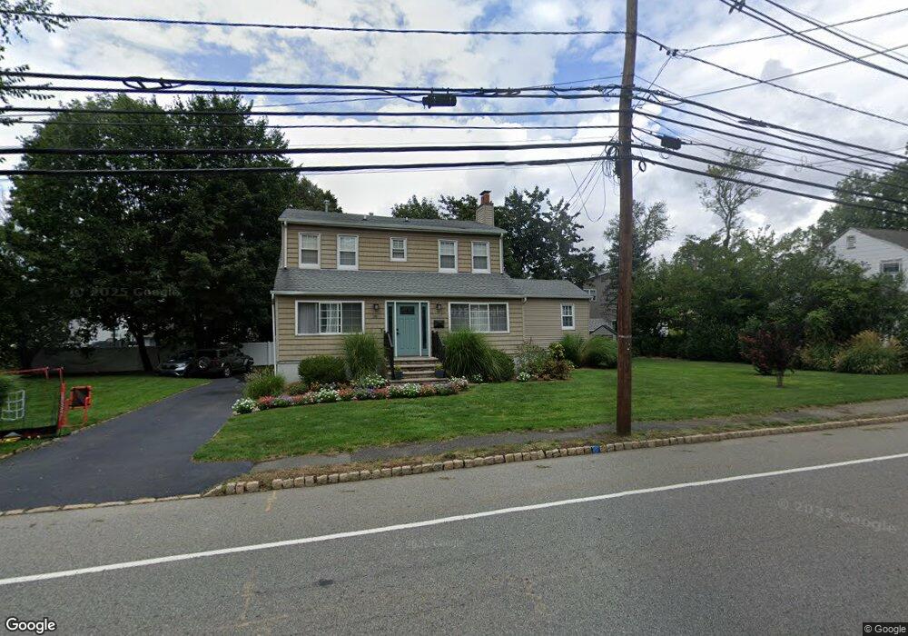
25 Passaic Ave Roseland, NJ 07068
Estimated Value: $637,000 - $759,155
--
Bed
--
Bath
1,590
Sq Ft
$442/Sq Ft
Est. Value
About This Home
This home is located at 25 Passaic Ave, Roseland, NJ 07068 and is currently estimated at $703,039, approximately $442 per square foot. 25 Passaic Ave is a home located in Essex County with nearby schools including Lester C. Noecker Elementary School, West Essex Middle School, and West Essex High School.
Ownership History
Date
Name
Owned For
Owner Type
Purchase Details
Closed on
Mar 28, 2021
Sold by
Garcia Gabriel and Garcia Elsa
Bought by
Garcia Klank Marisel
Current Estimated Value
Purchase Details
Closed on
Mar 26, 2021
Sold by
Garcia Gabriel and Garcia Elsa
Bought by
Garcia-Klank Marisel
Purchase Details
Closed on
Dec 31, 2014
Sold by
Garcia Elsa and Garcia Gabriel
Bought by
Garcia Elsa and Garcia Gabriel
Purchase Details
Closed on
Oct 6, 2011
Sold by
Estate Of Margaret U Hogya and Hogya Margaret Ann
Bought by
Garcia Gabriel and Garcia Elsa
Create a Home Valuation Report for This Property
The Home Valuation Report is an in-depth analysis detailing your home's value as well as a comparison with similar homes in the area
Home Values in the Area
Average Home Value in this Area
Purchase History
| Date | Buyer | Sale Price | Title Company |
|---|---|---|---|
| Garcia Klank Marisel | -- | Westcor Land Title Ins Co | |
| Garcia-Klank Marisel | -- | Land Title | |
| Garcia Elsa | -- | None Available | |
| Garcia Gabriel | $215,000 | Westcor Land Title Ins Co |
Source: Public Records
Tax History Compared to Growth
Tax History
| Year | Tax Paid | Tax Assessment Tax Assessment Total Assessment is a certain percentage of the fair market value that is determined by local assessors to be the total taxable value of land and additions on the property. | Land | Improvement |
|---|---|---|---|---|
| 2025 | $8,737 | $571,200 | $281,900 | $289,300 |
| 2024 | $8,737 | $571,200 | $281,900 | $289,300 |
| 2022 | $8,692 | $377,400 | $229,400 | $148,000 |
| 2021 | $8,661 | $377,400 | $229,400 | $148,000 |
| 2020 | $8,661 | $377,400 | $229,400 | $148,000 |
| 2019 | $8,582 | $377,400 | $229,400 | $148,000 |
| 2018 | $8,507 | $377,400 | $229,400 | $148,000 |
| 2017 | $8,503 | $377,400 | $229,400 | $148,000 |
| 2016 | $8,371 | $377,400 | $229,400 | $148,000 |
| 2015 | $8,390 | $377,400 | $229,400 | $148,000 |
| 2014 | $8,156 | $377,400 | $229,400 | $148,000 |
Source: Public Records
Map
Nearby Homes
- 26 Passaic Ave
- 38 Passaic Ave
- 518 Eagle Rock Ave
- 20 Lenape Dr
- 6 Mulford Ct Unit Address 6
- 6 Mulford Ct Unit C0013
- 88 Kent Dr Unit C0176
- 144 Passaic Ave
- 178 Passaic Ave
- 187 Passaic Ave
- 192 Eagle Rock Ave
- 30 Schweinberg Dr
- 41 W Mcclellan Ave
- 39 Schweinberg Dr Unit 2039
- 39 Schweinberg Dr
- 281 N Livingston Ave
- 11 Homestead Terrace
- 9 Cliffside Dr
- 8 Riker Hill Rd