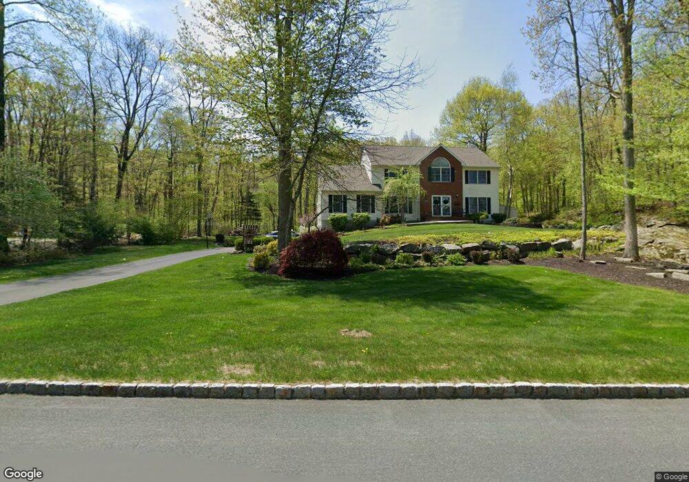
25 Pheasant Walk Sparta, NJ 07871
Estimated Value: $809,000 - $963,000
--
Bed
--
Bath
2,874
Sq Ft
$304/Sq Ft
Est. Value
About This Home
This home is located at 25 Pheasant Walk, Sparta, NJ 07871 and is currently estimated at $872,609, approximately $303 per square foot. 25 Pheasant Walk is a home located in Sussex County with nearby schools including Sparta High School, Hilltop Country Day School, and Pope John Xxiii High School.
Ownership History
Date
Name
Owned For
Owner Type
Purchase Details
Closed on
Apr 23, 1999
Sold by
Strogis Steven T and Strogis Ellen K
Bought by
Puszcz Stanley and Puszcz Ann
Current Estimated Value
Home Financials for this Owner
Home Financials are based on the most recent Mortgage that was taken out on this home.
Original Mortgage
$240,000
Interest Rate
7.5%
Purchase Details
Closed on
Mar 10, 1995
Sold by
Glendon Development Inc
Bought by
Strogis Steven T and Strogis Ellen K
Create a Home Valuation Report for This Property
The Home Valuation Report is an in-depth analysis detailing your home's value as well as a comparison with similar homes in the area
Home Values in the Area
Average Home Value in this Area
Purchase History
| Date | Buyer | Sale Price | Title Company |
|---|---|---|---|
| Puszcz Stanley | $357,200 | -- | |
| Strogis Steven T | $309,900 | Commonwealth Land Title Ins |
Source: Public Records
Mortgage History
| Date | Status | Borrower | Loan Amount |
|---|---|---|---|
| Previous Owner | Puszcz Stanley | $240,000 |
Source: Public Records
Tax History Compared to Growth
Tax History
| Year | Tax Paid | Tax Assessment Tax Assessment Total Assessment is a certain percentage of the fair market value that is determined by local assessors to be the total taxable value of land and additions on the property. | Land | Improvement |
|---|---|---|---|---|
| 2025 | $15,304 | $426,400 | $157,600 | $268,800 |
| 2024 | $14,864 | $426,400 | $157,600 | $268,800 |
| 2023 | $14,864 | $426,400 | $157,600 | $268,800 |
| 2022 | $14,506 | $426,400 | $157,600 | $268,800 |
| 2021 | $14,276 | $426,400 | $157,600 | $268,800 |
| 2020 | $14,498 | $426,400 | $157,600 | $268,800 |
| 2019 | $14,122 | $426,400 | $157,600 | $268,800 |
| 2018 | $13,824 | $426,400 | $157,600 | $268,800 |
| 2017 | $13,653 | $426,400 | $157,600 | $268,800 |
| 2016 | $13,334 | $426,400 | $157,600 | $268,800 |
| 2015 | $13,258 | $340,900 | $123,700 | $217,200 |
| 2014 | $13,043 | $340,900 | $123,700 | $217,200 |
Source: Public Records
Map
Nearby Homes
- 556 Glen Rd
- 20 Crestview Ln
- 53 Castlewood Trail
- 59 Fairmont Rd
- 72 Castlewood Trail
- 313 Glen Rd
- 24 Arapaho Trail
- 10 King Alex Ct
- 137 Main St
- 49 Morning Star Dr
- 3 Holland Cir
- 12 Richards St
- 34 Holland Cir
- 115 Scudders Rd
- 9 Madden Ave
- 64 Edison Ave
- 8 Plaskon Terrace
- 49 Edison Ave
- 33 Glenbrook Rd
- 3 Celia Dr