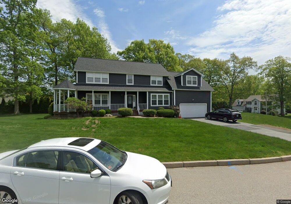
25 Red Hawk Dr Cranston, RI 02921
Comstock Gardens NeighborhoodEstimated Value: $848,590 - $997,000
4
Beds
3
Baths
3,218
Sq Ft
$288/Sq Ft
Est. Value
About This Home
This home is located at 25 Red Hawk Dr, Cranston, RI 02921 and is currently estimated at $926,398, approximately $287 per square foot. 25 Red Hawk Dr is a home located in Providence County with nearby schools including Orchard Farms El. School, Western Hills Middle School, and Cranston High School West.
Ownership History
Date
Name
Owned For
Owner Type
Purchase Details
Closed on
Aug 5, 2005
Sold by
Aziz George F and Aziz Nermeen
Bought by
Reilly Raymond E and Reilly Jessica R
Current Estimated Value
Home Financials for this Owner
Home Financials are based on the most recent Mortgage that was taken out on this home.
Original Mortgage
$265,000
Interest Rate
5.63%
Mortgage Type
Purchase Money Mortgage
Purchase Details
Closed on
Apr 17, 2001
Sold by
Hochwart Edgar and Hochwart Beate
Bought by
Aziz George F
Purchase Details
Closed on
May 15, 2000
Sold by
Lafleur Barry J
Bought by
Hochwart Edgar and Hochwart Beate
Create a Home Valuation Report for This Property
The Home Valuation Report is an in-depth analysis detailing your home's value as well as a comparison with similar homes in the area
Home Values in the Area
Average Home Value in this Area
Purchase History
| Date | Buyer | Sale Price | Title Company |
|---|---|---|---|
| Reilly Raymond E | $515,000 | -- | |
| Aziz George F | $317,000 | -- | |
| Hochwart Edgar | $300,000 | -- |
Source: Public Records
Mortgage History
| Date | Status | Borrower | Loan Amount |
|---|---|---|---|
| Open | Hochwart Edgar | $234,000 | |
| Closed | Hochwart Edgar | $240,000 | |
| Closed | Hochwart Edgar | $247,500 | |
| Closed | Hochwart Edgar | $265,000 |
Source: Public Records
Tax History
| Year | Tax Paid | Tax Assessment Tax Assessment Total Assessment is a certain percentage of the fair market value that is determined by local assessors to be the total taxable value of land and additions on the property. | Land | Improvement |
|---|---|---|---|---|
| 2025 | $9,536 | $687,000 | $167,500 | $519,500 |
| 2024 | $9,350 | $687,000 | $167,500 | $519,500 |
| 2023 | $9,756 | $516,200 | $119,700 | $396,500 |
| 2022 | $9,555 | $516,200 | $119,700 | $396,500 |
| 2021 | $9,292 | $516,200 | $119,700 | $396,500 |
| 2020 | $9,166 | $441,300 | $124,000 | $317,300 |
| 2019 | $9,166 | $441,300 | $124,000 | $317,300 |
| 2018 | $8,954 | $441,300 | $124,000 | $317,300 |
| 2017 | $9,353 | $407,700 | $115,400 | $292,300 |
| 2016 | $9,153 | $407,700 | $115,400 | $292,300 |
| 2015 | $9,153 | $407,700 | $115,400 | $292,300 |
| 2014 | $9,065 | $396,900 | $124,000 | $272,900 |
Source: Public Records
Map
Nearby Homes
- 117 Moccasin Trail
- 82 Mohawk Trail
- 0 Anthony Dr Unit 1394338
- 71 Elite Dr
- 51 Janet Dr
- 105 Amy Dr
- 311 Hope Rd
- 1495 Pippin Orchard Rd
- 25 Janet Dr
- 9 Gray Coach Ln Unit 911
- 1221 Phenix Ave
- 38 Angela Ave
- 1213 Phenix Ave
- 02 Paula Ln
- 01 Paula Ln
- 12 Beechwood Dr
- 1835 Plainfield Pike
- 154 Beechwood Dr
- 1100 Phenix Ave
- 178 Highland St
- 21 Red Hawk Dr
- 33 Red Hawk Dr
- 32 Red Hawk Dr
- 38 Red Hawk Dr
- 24 Red Hawk Dr
- 14 Red Hawk Dr
- 30 Red Hawk Dr
- 11 Red Hawk Dr
- 44 Red Hawk Dr
- 205 Tomahawk Trail
- 207 Tomahawk Trail
- 115 S Comstock Pkwy
- 111 S Comstock Pkwy
- 43 Red Hawk Dr
- 65 S Comstock Pkwy
- 213 Tomahawk Trail
- 50 Red Hawk Dr
- 195 Tomahawk Trail
- 2 Red Hawk Dr
- 95 S Comstock Pkwy
Your Personal Tour Guide
Ask me questions while you tour the home.