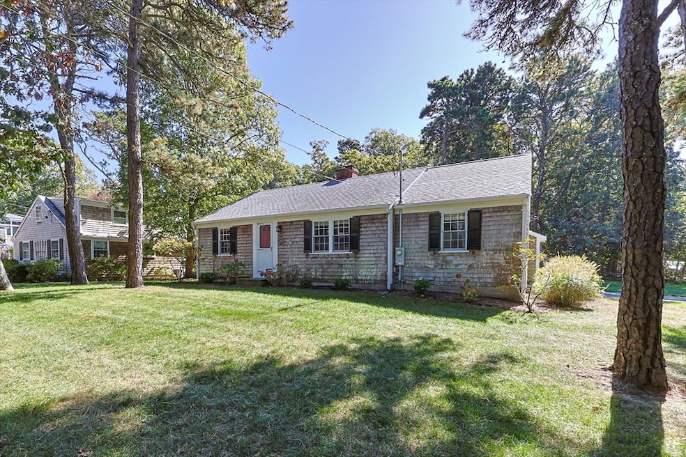
25 Robbins Rd Harwich Port, MA 02646
Harwich Port NeighborhoodEstimated payment $3,668/month
Highlights
- Marina
- Golf Course Community
- Spa
- Chatham Elementary School Rated A-
- Medical Services
- Cape Cod Architecture
About This Home
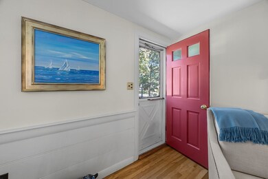
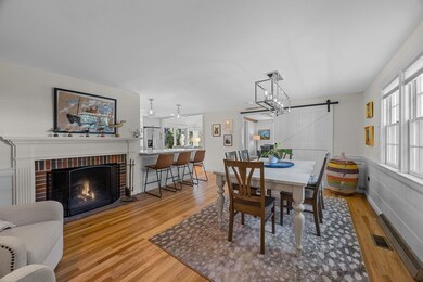
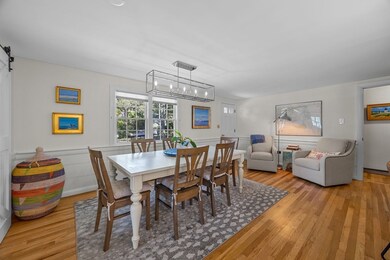
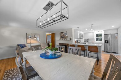
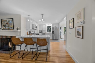
Step right into this inviting home and embrace the simplicity of single-floor living, perfect for accommodating family and friends. Relax by the cozy wood-burning fireplace in the living room or enjoy the warmth of the gas fireplace in the sunroom. The home opens up to a secluded outdoor living area, featuring a generous patio, a hot tub, and an outdoor shower. For your storage needs, there are two sheds that can double as studio space. Located conveniently close to beaches, shopping, dining, golf courses, biking trails, and the stunning natural scenery of Harwich and its neighboring towns, this property offers both comfort and convenience.

Home Details
Home Type
- Single Family
Est. Annual Taxes
- $2,814
Year Built
- Built in 1958
Lot Details
- 0.25 Acre Lot
- Corner Lot
- Level Lot
Home Design
- Cape Cod Architecture
- Ranch Style House
- Block Foundation
- Frame Construction
- Shake Roof
- Shingle Roof
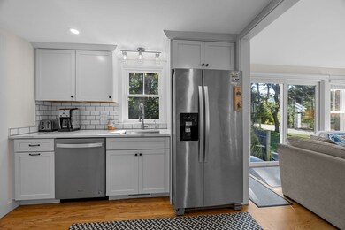
Interior Spaces
- 1,092 Sq Ft Home
- 2 Fireplaces
- Wood Flooring
Kitchen
- Range
- Microwave
- Dishwasher
Bedrooms and Bathrooms
- 2 Bedrooms
Laundry
- Dryer
- Washer
Parking
- 4 Car Parking Spaces
- Off-Street Parking
Pool
- Spa
- Outdoor Shower
Outdoor Features
- Patio
- Outdoor Storage
Location
- Property is near public transit
- Property is near schools
Schools
- Harwich Elementary School
- Monomoy Middle School
- Monomoy High School
Utilities
- Window Unit Cooling System
- Forced Air Heating System
- Heating System Uses Natural Gas
- Tankless Water Heater
- Private Sewer
Listing and Financial Details
- Assessor Parcel Number 22A226,2332356
Community Details
Overview
- No Home Owners Association
- Near Conservation Area
Amenities
- Medical Services
- Shops
- Coin Laundry
Recreation
- Marina
- Golf Course Community
- Tennis Courts
- Park
- Jogging Path
- Bike Trail
Map
Home Values in the Area
Average Home Value in this Area
Tax History
| Year | Tax Paid | Tax Assessment Tax Assessment Total Assessment is a certain percentage of the fair market value that is determined by local assessors to be the total taxable value of land and additions on the property. | Land | Improvement |
|---|---|---|---|---|
| 2025 | $2,814 | $476,200 | $199,600 | $276,600 |
| 2024 | $2,710 | $449,500 | $188,300 | $261,200 |
| 2023 | $2,627 | $395,600 | $171,200 | $224,400 |
| 2022 | $2,596 | $320,100 | $148,900 | $171,200 |
| 2021 | $2,447 | $284,500 | $135,400 | $149,100 |
| 2020 | $2,049 | $234,700 | $132,500 | $102,200 |
| 2019 | $1,938 | $223,500 | $127,100 | $96,400 |
| 2018 | $1,928 | $212,700 | $115,600 | $97,100 |
| 2017 | $1,770 | $197,300 | $105,300 | $92,000 |
| 2016 | $1,744 | $192,300 | $105,300 | $87,000 |
| 2015 | $1,694 | $188,800 | $103,200 | $85,600 |
| 2014 | $1,611 | $183,700 | $100,600 | $83,100 |
Property History
| Date | Event | Price | List to Sale | Price per Sq Ft |
|---|---|---|---|---|
| 10/15/2025 10/15/25 | Pending | -- | -- | -- |
| 10/10/2025 10/10/25 | For Sale | $650,000 | -- | $595 / Sq Ft |
Purchase History
| Date | Type | Sale Price | Title Company |
|---|---|---|---|
| Quit Claim Deed | -- | None Available | |
| Quit Claim Deed | -- | None Available | |
| Deed | $98,500 | -- | |
| Deed | $89,500 | -- | |
| Deed | $98,500 | -- | |
| Deed | $89,500 | -- |
Mortgage History
| Date | Status | Loan Amount | Loan Type |
|---|---|---|---|
| Previous Owner | $120,000 | No Value Available | |
| Previous Owner | $65,000 | Purchase Money Mortgage | |
| Previous Owner | $71,600 | Purchase Money Mortgage |
Source: MLS Property Information Network (MLS PIN)
MLS Number: 73441043
APN: HARW-000022-000000-A000002-000026
Disclaimer: Certain information contained herein is derived from information provided by parties other than Homes.com. All information provided is deemed reliable, but is not guaranteed to be accurate and should be independently verified.
![]() The property listing data and information, or the Images, set forth herein were provided to MLS Property Information Network, Inc. from third party sources, including sellers, lessors and public records, and were compiled by MLS Property Information Network, Inc. The property listing data and information, and the Images, are for the personal, non-commercial use of consumers having a good faith interest in purchasing or leasing listed properties of the type displayed to them and may not be used for any purpose other than to identify prospective properties which such consumers may have a good faith interest in purchasing or leasing. MLS Property Information Network, Inc. and its subscribers disclaim any and all representations and warranties as to the accuracy of the property listing data and information, or as to the accuracy of any of the Images, set forth herein.
The property listing data and information, or the Images, set forth herein were provided to MLS Property Information Network, Inc. from third party sources, including sellers, lessors and public records, and were compiled by MLS Property Information Network, Inc. The property listing data and information, and the Images, are for the personal, non-commercial use of consumers having a good faith interest in purchasing or leasing listed properties of the type displayed to them and may not be used for any purpose other than to identify prospective properties which such consumers may have a good faith interest in purchasing or leasing. MLS Property Information Network, Inc. and its subscribers disclaim any and all representations and warranties as to the accuracy of the property listing data and information, or as to the accuracy of any of the Images, set forth herein.
- 135 Sisson Rd
- 15 Pleasant St Unit W24
- 9 Jason Ln
- 18 Old Campground
- 12 Old Campground Rd
- 515 Route 28
- 515 Massachusetts 28
- 116 Parallel St
- 53 Freeman St
- 303 Bank St
- 405 Lower County Rd Unit 21
- 405 Lower County Rd Unit 23
- 15 Shannon Rd
- 2 Bassett Woods Rd
- 23 Zylpha Rd
- 44 Beriah Brooks Rd
- 292 Massachusetts 28 Unit 1
- 292 Massachusetts 28 Unit 7
- 28 Dale Rd
- 8 Wyndemere Bluffs Rd