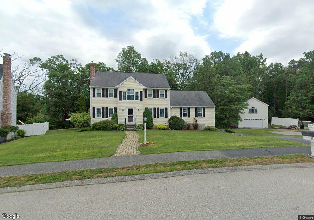
25 Rollie Shepard Dr Millbury, MA 01527
Estimated Value: $689,777 - $746,000
3
Beds
3
Baths
2,520
Sq Ft
$285/Sq Ft
Est. Value
About This Home
This home is located at 25 Rollie Shepard Dr, Millbury, MA 01527 and is currently estimated at $718,194, approximately $284 per square foot. 25 Rollie Shepard Dr is a home located in Worcester County with nearby schools including Elmwood Street Elementary School, Raymond E. Shaw Elementary School, and Millbury Junior/Senior High School.
Ownership History
Date
Name
Owned For
Owner Type
Purchase Details
Closed on
Apr 24, 2018
Sold by
Chapman Paula J
Bought by
Mulhern Brian W and Mulhern Lauren J
Current Estimated Value
Home Financials for this Owner
Home Financials are based on the most recent Mortgage that was taken out on this home.
Original Mortgage
$331,000
Outstanding Balance
$284,787
Interest Rate
4.46%
Mortgage Type
New Conventional
Estimated Equity
$433,407
Purchase Details
Closed on
Jan 31, 2000
Sold by
Rollie Shepard Rt and Miles John Todd
Bought by
Chapman Kevin J and Chapman Paula J
Create a Home Valuation Report for This Property
The Home Valuation Report is an in-depth analysis detailing your home's value as well as a comparison with similar homes in the area
Home Values in the Area
Average Home Value in this Area
Purchase History
| Date | Buyer | Sale Price | Title Company |
|---|---|---|---|
| Mulhern Brian W | $413,750 | -- | |
| Chapman Kevin J | $220,000 | -- |
Source: Public Records
Mortgage History
| Date | Status | Borrower | Loan Amount |
|---|---|---|---|
| Open | Mulhern Brian W | $331,000 | |
| Previous Owner | Chapman Kevin J | $300,000 | |
| Previous Owner | Chapman Kevin J | $250,000 | |
| Previous Owner | Chapman Kevin J | $199,500 | |
| Previous Owner | Chapman Kevin J | $38,000 |
Source: Public Records
Tax History
| Year | Tax Paid | Tax Assessment Tax Assessment Total Assessment is a certain percentage of the fair market value that is determined by local assessors to be the total taxable value of land and additions on the property. | Land | Improvement |
|---|---|---|---|---|
| 2025 | $8,740 | $652,700 | $131,400 | $521,300 |
| 2024 | $8,012 | $605,600 | $121,500 | $484,100 |
| 2023 | $7,289 | $504,400 | $84,900 | $419,500 |
| 2022 | $6,489 | $432,600 | $84,900 | $347,700 |
| 2021 | $11,606 | $414,200 | $84,900 | $329,300 |
| 2020 | $7,554 | $408,000 | $84,900 | $323,100 |
| 2019 | $5,777 | $364,500 | $84,500 | $280,000 |
| 2018 | $10,503 | $350,500 | $84,500 | $266,000 |
| 2017 | $5,338 | $324,900 | $84,500 | $240,400 |
| 2016 | $5,425 | $329,600 | $84,500 | $245,100 |
| 2015 | $5,254 | $319,200 | $85,900 | $233,300 |
| 2014 | $4,921 | $287,800 | $89,800 | $198,000 |
Source: Public Records
Map
Nearby Homes
- 48 Macarthur Dr
- 2 Diane St
- 12 Irene Ct
- 2 Wilson Rd Unit B
- 2 Wilson Rd Unit A
- 51 John Dr Unit 51
- 15 Jackson Ln
- 123 Riverlin St
- 11 Maplewood Rd
- 1459 Grafton Rd
- 20 Woodridge Rd
- 13 Braney Rd
- 156 Brigham Hill Rd
- 12 Village Green
- 182 Weatherstone Dr
- 18 Lincoln Ave
- 7 Clarissa St
- Lot 1 Cooper Rd
- 8 Autumn Gate Cir
- 1195 Grafton St Unit 39
- 23 Rollie Shepard Dr
- 27 Rollie Shepard Dr
- 21 Rollie Shepard Dr
- 9 Montgomery Dr
- 7 Montgomery Dr
- 20 Rollie Shepard Dr
- 19 Rollie Shepard Dr
- 11 Montgomery Dr
- 5 Montgomery Dr
- 18 Rollie Shepard Dr
- 6 Montgomery Dr
- 8 Montgomery Dr
- 4 Montgomery Dr
- 17 Rollie Shepard Dr
- 2 Montgomery Dr
- 16 Rollie Shepard Dr
- 137 Macarthur Dr
- 3 Montgomery Dr
- 15 Rollie Shepard Dr
- 135 Macarthur Dr