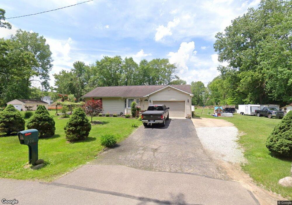
250 2nd St SE Barberton, OH 44203
East Barberton NeighborhoodEstimated Value: $207,000 - $250,547
3
Beds
2
Baths
1,346
Sq Ft
$170/Sq Ft
Est. Value
About This Home
This home is located at 250 2nd St SE, Barberton, OH 44203 and is currently estimated at $228,637, approximately $169 per square foot. 250 2nd St SE is a home located in Summit County with nearby schools including Barberton Intermediate School 3-5, Barberton Middle School, and Barberton High School.
Ownership History
Date
Name
Owned For
Owner Type
Purchase Details
Closed on
Jun 12, 2002
Sold by
Reffner Shirley G
Bought by
Krivokuca Milos and Krivokuca Draga
Current Estimated Value
Home Financials for this Owner
Home Financials are based on the most recent Mortgage that was taken out on this home.
Original Mortgage
$121,739
Outstanding Balance
$51,692
Interest Rate
6.87%
Mortgage Type
FHA
Estimated Equity
$176,945
Purchase Details
Closed on
Jan 12, 1996
Sold by
Neighborhood Converation
Bought by
Reffner Robert P and Reffner Shirley G
Home Financials for this Owner
Home Financials are based on the most recent Mortgage that was taken out on this home.
Original Mortgage
$50,500
Interest Rate
7.36%
Mortgage Type
New Conventional
Create a Home Valuation Report for This Property
The Home Valuation Report is an in-depth analysis detailing your home's value as well as a comparison with similar homes in the area
Home Values in the Area
Average Home Value in this Area
Purchase History
| Date | Buyer | Sale Price | Title Company |
|---|---|---|---|
| Krivokuca Milos | $123,650 | Midland Commerce Group Fairl | |
| Reffner Robert P | $80,546 | -- |
Source: Public Records
Mortgage History
| Date | Status | Borrower | Loan Amount |
|---|---|---|---|
| Open | Krivokuca Milos | $121,739 | |
| Closed | Reffner Robert P | $50,500 |
Source: Public Records
Tax History Compared to Growth
Tax History
| Year | Tax Paid | Tax Assessment Tax Assessment Total Assessment is a certain percentage of the fair market value that is determined by local assessors to be the total taxable value of land and additions on the property. | Land | Improvement |
|---|---|---|---|---|
| 2025 | $3,534 | $70,648 | $19,842 | $50,806 |
| 2024 | $3,534 | $70,648 | $19,842 | $50,806 |
| 2023 | $3,534 | $70,648 | $19,842 | $50,806 |
| 2022 | $2,619 | $45,312 | $12,639 | $32,673 |
| 2021 | $2,616 | $45,312 | $12,639 | $32,673 |
| 2020 | $2,560 | $45,310 | $12,640 | $32,670 |
| 2019 | $2,249 | $36,030 | $9,480 | $26,550 |
| 2018 | $2,215 | $36,030 | $9,480 | $26,550 |
| 2017 | $2,208 | $36,030 | $9,480 | $26,550 |
| 2016 | $2,212 | $35,450 | $9,480 | $25,970 |
| 2015 | $2,208 | $35,450 | $9,480 | $25,970 |
| 2014 | $2,196 | $35,450 | $9,480 | $25,970 |
| 2013 | $2,133 | $35,590 | $9,480 | $26,110 |
Source: Public Records
Map
Nearby Homes
- 43 S Van Buren Ave
- 25 S Van Buren Ave
- 327 Robinson Ave
- 251 Slate Ridge Dr
- 311 Holly Place
- 6 5th St NE
- 588 Austin Dr
- 477 Robinson Ave
- 414 E Baird Ave
- 64 Diamond Ave
- 369 Big Bend Cir
- 375 Big Bend Cir
- 1110 Mansion Dr
- 357 E Paige Ave
- 650 E Tuscarawas Ave
- 349 E Hopocan Ave
- 344 E Huston St
- 986 S Azalea Blvd
- 46 Brown St
- 673 Wooster Rd W
- 341 Snyder Ave
- 371 Snyder Ave
- 336 Snyder Ave
- 340 Snyder Ave
- 348 Snyder Ave
- 336 Lamberton Ave
- 366 Lamberton Ave
- 350 Lamberton Ave
- 364 Snyder Ave
- 381 Snyder Ave
- 324 Snyder Ave
- 330 Lamberton Ave
- 362 Snyder Ave Unit 364
- 328 330 Lamberton Ave
- 316 Snyder Ave
- 368 Snyder Ave
- 328 Lamberton Ave Unit 330
- 301 Snyder Ave
- 289 George St
- 300 Frank Ave