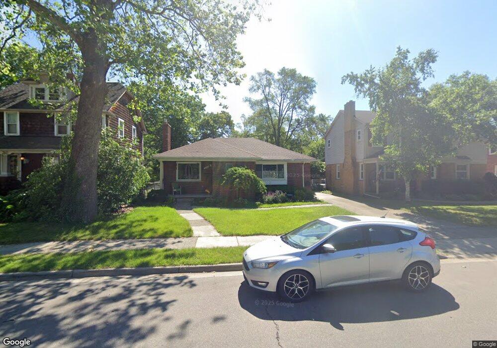
250 Allen St Ferndale, MI 48220
Estimated Value: $256,000 - $265,000
2
Beds
2
Baths
1,026
Sq Ft
$253/Sq Ft
Est. Value
About This Home
This home is located at 250 Allen St, Ferndale, MI 48220 and is currently estimated at $260,001, approximately $253 per square foot. 250 Allen St is a home located in Oakland County with nearby schools including Ferndale Lower Elementary Campus, Ferndale Upper Elementary Campus, and Ferndale Middle School.
Ownership History
Date
Name
Owned For
Owner Type
Purchase Details
Closed on
Feb 29, 2024
Sold by
Freed Rosanne and Freed Rosanne D
Bought by
Freed Rosanne D and Rosanne D Freed Trust
Current Estimated Value
Purchase Details
Closed on
Jul 19, 2002
Sold by
Perry Ronald W
Bought by
Freed Rosanne
Home Financials for this Owner
Home Financials are based on the most recent Mortgage that was taken out on this home.
Original Mortgage
$114,400
Interest Rate
6.7%
Create a Home Valuation Report for This Property
The Home Valuation Report is an in-depth analysis detailing your home's value as well as a comparison with similar homes in the area
Home Values in the Area
Average Home Value in this Area
Purchase History
| Date | Buyer | Sale Price | Title Company |
|---|---|---|---|
| Freed Rosanne D | -- | Land Title | |
| Freed Rosanne | $143,000 | -- |
Source: Public Records
Mortgage History
| Date | Status | Borrower | Loan Amount |
|---|---|---|---|
| Previous Owner | Freed Rosanne | $114,400 |
Source: Public Records
Tax History
| Year | Tax Paid | Tax Assessment Tax Assessment Total Assessment is a certain percentage of the fair market value that is determined by local assessors to be the total taxable value of land and additions on the property. | Land | Improvement |
|---|---|---|---|---|
| 2025 | $2,863 | $131,110 | $0 | $0 |
| 2024 | $2,751 | $122,560 | $0 | $0 |
| 2023 | $2,671 | $111,800 | $0 | $0 |
| 2022 | $2,682 | $100,460 | $0 | $0 |
| 2021 | $2,698 | $88,740 | $0 | $0 |
| 2020 | $2,558 | $80,050 | $0 | $0 |
| 2019 | $2,541 | $75,440 | $0 | $0 |
| 2018 | $2,550 | $69,750 | $0 | $0 |
| 2017 | $2,518 | $68,940 | $0 | $0 |
| 2016 | $2,485 | $57,830 | $0 | $0 |
| 2015 | -- | $48,570 | $0 | $0 |
| 2014 | -- | $42,310 | $0 | $0 |
| 2011 | -- | $53,210 | $0 | $0 |
Source: Public Records
Map
Nearby Homes
- 230 Allen St
- 335 Laprairie St
- 591 Parkside Way Unit 16
- 207 Saint Louis St
- 3127 W 8 Mile Rd
- 210 Saint Louis St
- 20441 Gardendale St
- 359 Edgewood Place
- 526 Saint Louis St
- 457 W Bennett
- 2720 Woodstock Dr
- 20160 Stratford Rd
- 808 Laprairie St
- 293 Fielding St
- 311 Adams Ct
- 695 Livernois St
- 2597 W 8 Mile Rd
- 20073 Shrewsbury Rd
- 1368 Northway St
- 231 W Bennett Ave
- 306 Allen St
- 240 Allen St
- 260 Allen St
- 312 Allen St
- 224 Allen St
- 322 Allen St
- 214 Allen St
- 340 Allen St
- 350 Allen St
- 231 Laprairie St
- 400 Allen St
- 331 Laprairie St
- 251 Laprairie St
- 261 Laprairie St
- 233 Laprairie St
- 408 Allen St
- 515 Parkside Way
- 527 Parkside Way Unit 55
- 515 Parkside Way Unit 57
- 505 Parkside Way Unit 58
Your Personal Tour Guide
Ask me questions while you tour the home.