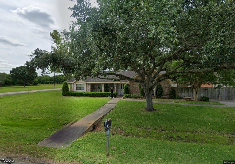
250 Camellia Dr Brazoria, TX 77422
Estimated Value: $268,000 - $283,000
3
Beds
2
Baths
1,931
Sq Ft
$144/Sq Ft
Est. Value
About This Home
This home is located at 250 Camellia Dr, Brazoria, TX 77422 and is currently estimated at $277,995, approximately $143 per square foot. 250 Camellia Dr is a home located in Brazoria County.
Ownership History
Date
Name
Owned For
Owner Type
Purchase Details
Closed on
Oct 5, 2007
Sold by
Taylor James E and Taylor Verna Darlene
Bought by
Patsy Sandlin Thompson Trust and Thompson Patsy S
Current Estimated Value
Purchase Details
Closed on
Dec 30, 1998
Sold by
Shipman Dale K and Shipman Kathy S
Bought by
Taylor James E and Taylor Verna Darlene
Home Financials for this Owner
Home Financials are based on the most recent Mortgage that was taken out on this home.
Original Mortgage
$91,500
Interest Rate
6.85%
Create a Home Valuation Report for This Property
The Home Valuation Report is an in-depth analysis detailing your home's value as well as a comparison with similar homes in the area
Home Values in the Area
Average Home Value in this Area
Purchase History
| Date | Buyer | Sale Price | Title Company |
|---|---|---|---|
| Patsy Sandlin Thompson Trust | -- | American Title Company | |
| Taylor James E | -- | -- |
Source: Public Records
Mortgage History
| Date | Status | Borrower | Loan Amount |
|---|---|---|---|
| Previous Owner | Taylor James E | $91,500 |
Source: Public Records
Tax History Compared to Growth
Tax History
| Year | Tax Paid | Tax Assessment Tax Assessment Total Assessment is a certain percentage of the fair market value that is determined by local assessors to be the total taxable value of land and additions on the property. | Land | Improvement |
|---|---|---|---|---|
| 2025 | $3,911 | $293,310 | $34,270 | $259,040 |
| 2023 | $3,911 | $303,200 | $31,010 | $272,190 |
| 2022 | $5,617 | $248,670 | $27,360 | $221,310 |
| 2021 | $4,893 | $207,620 | $23,710 | $183,910 |
| 2020 | $4,920 | $198,890 | $21,890 | $177,000 |
| 2019 | $4,863 | $190,490 | $18,240 | $172,250 |
| 2018 | $4,486 | $174,780 | $21,890 | $152,890 |
| 2017 | $4,886 | $184,080 | $21,890 | $162,190 |
| 2016 | $4,601 | $173,330 | $18,240 | $155,090 |
| 2015 | $3,676 | $160,290 | $18,240 | $142,050 |
| 2014 | $3,676 | $136,980 | $18,240 | $118,740 |
Source: Public Records
Map
Nearby Homes
- 232 Magnolia St
- 229 Yaupon Dr
- 523 Lazy Ln
- 0 Pecan Dr
- 307 Avenue G
- 409 Carlton St
- 1208 S Brooks St
- 706 E New York St
- 230 E New York St
- 549 E New York St
- 34654 Fm 521 Rd
- 8922 Fm 521 Rd
- 4773 County Road 652
- 310 E Texas St
- 401 E Texas St
- 0 Cr-747a
- TBD Cr-318
- 320 Cr-320
- 0 Cr-318 Unit 18304666
- TBD Cr-318 Tract 7c