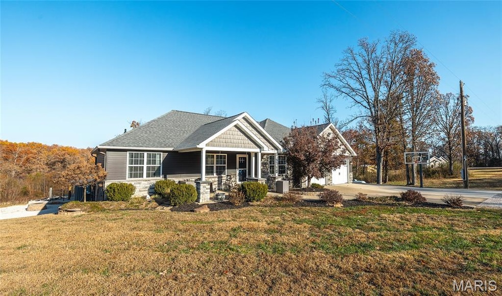


2501 Highway Af Sullivan, MO 63080
Estimated payment $3,462/month
Highlights
- In Ground Pool
- 4.17 Acre Lot
- Deck
- Spring Bluff Elementary School Rated A-
- Open Floorplan
- Ranch Style House
About This Home
New Price Improvement!! Beautiful custom-built home on 4 plus acres in the Spring bluff School District
Large spacious Great Room with beautiful solid hickory flooring, Kitchen with Custom Cabinets and large Island with butcher block countertops, Refrigerator, Stove, Dishwasher and Microwave. Separate Office area with French Doors for working from Home, Master Suite with Coiffured Ceiling, 2 additional bedrooms, bath and Laundry Room. French Doors lead to large composite Deck Lower level is complete with Living Area with beautiful European Pine Walls, Kitchen with Stove, (refrigerator does not stay) Master Suite, Laundry Room and Second Bedroom.
Home has High Efficiency Gas Furnace and HVAC System. Home has whole home water filtration system with instant water heating system. Walkout to Large covered Patio, Beautiful Fiberglass Salt Water Inground Pool with walk on Pool cover, Slide and Gazebo area. 2 Car Attached garage with petitioned work area with draft hood
HAS CONTINGENCY CONTRACT - WILL CONTINUE TO SHOW
Home Details
Home Type
- Single Family
Est. Annual Taxes
- $3,706
Year Built
- Built in 2018
Lot Details
- 4.17 Acre Lot
- Landscaped
- Irregular Lot
Parking
- 2 Car Garage
- Oversized Parking
- Lighted Parking
- Front Facing Garage
- Garage Door Opener
- Driveway
- Additional Parking
Home Design
- Ranch Style House
- Frame Construction
- Vinyl Siding
Interior Spaces
- Open Floorplan
- Coffered Ceiling
- Cathedral Ceiling
- Ceiling Fan
- Double Pane Windows
- French Doors
- Great Room
- Combination Dining and Living Room
- Storage
Kitchen
- Range
- Dishwasher
- Stainless Steel Appliances
- Solid Surface Countertops
- Instant Hot Water
Flooring
- Wood
- Carpet
- Luxury Vinyl Tile
Bedrooms and Bathrooms
- 5 Bedrooms
- Walk-In Closet
- Double Vanity
- Separate Shower
Laundry
- Laundry Room
- Laundry on main level
- Gas Dryer Hookup
Finished Basement
- Walk-Out Basement
- Basement Fills Entire Space Under The House
- 9 Foot Basement Ceiling Height
- Finished Basement Bathroom
- Laundry in Basement
- Basement Window Egress
Eco-Friendly Details
- ENERGY STAR Qualified Equipment
Pool
- In Ground Pool
- Outdoor Pool
- Pool Cover
Outdoor Features
- Deck
- Covered Patio or Porch
- Fire Pit
- Exterior Lighting
Schools
- Spring Bluff Elem. Elementary And Middle School
- Sullivan Sr. High School
Utilities
- Central Air
- Heating System Powered By Leased Propane
- Heating System Uses Propane
- 220 Volts
- Well
- Tankless Water Heater
- Water Softener
- Septic Tank
- Cable TV Available
Listing and Financial Details
- Assessor Parcel Number 28-9-290-0-005-00510
Community Details
Overview
- No Home Owners Association
Recreation
- Community Pool
Map
Home Values in the Area
Average Home Value in this Area
Tax History
| Year | Tax Paid | Tax Assessment Tax Assessment Total Assessment is a certain percentage of the fair market value that is determined by local assessors to be the total taxable value of land and additions on the property. | Land | Improvement |
|---|---|---|---|---|
| 2025 | $4,016 | $72,760 | $0 | $0 |
| 2024 | $4,016 | $70,156 | $0 | $0 |
| 2023 | $3,706 | $70,156 | $0 | $0 |
| 2022 | $3,063 | $57,677 | $0 | $0 |
| 2021 | $2,973 | $57,677 | $0 | $0 |
| 2020 | $2,729 | $51,312 | $0 | $0 |
| 2019 | $2,696 | $51,312 | $0 | $0 |
| 2018 | $1,765 | $33,254 | $0 | $0 |
| 2017 | $0 | $1,801 | $0 | $0 |
Property History
| Date | Event | Price | List to Sale | Price per Sq Ft |
|---|---|---|---|---|
| 01/12/2026 01/12/26 | Price Changed | $590,000 | -4.8% | $152 / Sq Ft |
| 12/02/2025 12/02/25 | Price Changed | $620,000 | -4.3% | $160 / Sq Ft |
| 11/10/2025 11/10/25 | For Sale | $648,000 | -- | $167 / Sq Ft |
Purchase History
| Date | Type | Sale Price | Title Company |
|---|---|---|---|
| Warranty Deed | -- | None Available | |
| Interfamily Deed Transfer | -- | -- |
Mortgage History
| Date | Status | Loan Amount | Loan Type |
|---|---|---|---|
| Closed | $533,800 | New Conventional |
Source: MARIS MLS
MLS Number: MIS25075386
APN: 28-9-29.0-0-005-005.100
Disclaimer: Certain information contained herein is derived from information provided by parties other than Homes.com. All information provided is deemed reliable, but is not guaranteed to be accurate and should be independently verified.
![]() Based on information submitted to the MLS GRID. All data is obtained from various sources and may not have been verified by broker or MLS GRID. Supplied Open House Information is subject to change without notice. All information should be independently reviewed and verified for accuracy. Properties may or may not be listed by the office/agent presenting the information. Some IDX listings have been excluded from this website.
Based on information submitted to the MLS GRID. All data is obtained from various sources and may not have been verified by broker or MLS GRID. Supplied Open House Information is subject to change without notice. All information should be independently reviewed and verified for accuracy. Properties may or may not be listed by the office/agent presenting the information. Some IDX listings have been excluded from this website.
Based on information submitted to the MLS GRID
- 0 Ridge Rd Unit MIS26003377
- 1329 N Service Rd E
- 738 Huntington Woods Dr
- 1451 Spring Bluff Rd
- 994 Acid Mine Rd
- 910 Oak Pass Ln
- 1112 N and South Rd S
- 478 Del Ridge Dr
- 1116 E Springfield Rd
- 1019 E Springfield Rd
- 233 Bud St
- 0 Mesa Dr
- 121 Mervin St
- 311 S Highway 185
- 107 Glaser Rd
- 752 Hammer Stone Place
- 430 Scottsdale Dr
- 132 Virginia St
- 1168 Lance St
- 1070 Georgia St
- 104 Mulligan St
- 125 Crescent Lake Rd Unit 111
- 990 S Lay Ave
- 30 E Lewis St Unit A
- 25 Maple St
- 1050 Plaza Ct N Unit 23
- 100-300 Autumn Leaf Dr
- 1399 W Springfield Ave
- 101 Chapel Ridge Dr
- 1017 Don Ave
- 403 Frank St
- 155 Summit Valley Loop
- 2615 Lisa Ln
- 1517 W Pacific St
- 613 Palisades Dr Unit 613
- 624 Palisades Dr Unit 624
- 619 Palisades Dr
- 109 E Jefferson St Unit 5
- 1235 Wild Horse Creek Rd

Ask me questions while you tour the home.