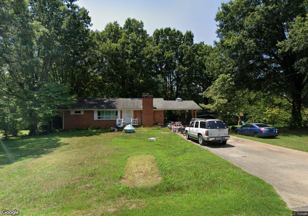
2504 Daffodil Rd Reidsville, NC 27320
Estimated Value: $242,092 - $291,000
--
Bed
1
Bath
1,612
Sq Ft
$161/Sq Ft
Est. Value
About This Home
This home is located at 2504 Daffodil Rd, Reidsville, NC 27320 and is currently estimated at $260,273, approximately $161 per square foot. 2504 Daffodil Rd is a home located in Rockingham County with nearby schools including Monroeton Elementary School, Rockingham County Middle School, and Rockingham County High School.
Ownership History
Date
Name
Owned For
Owner Type
Purchase Details
Closed on
Aug 18, 2016
Sold by
Warf Timothy L and Greeson Sylvia R
Bought by
Thompson Michael Wayne and Thompson Heather Michelle
Current Estimated Value
Home Financials for this Owner
Home Financials are based on the most recent Mortgage that was taken out on this home.
Original Mortgage
$129,609
Outstanding Balance
$106,680
Interest Rate
4.5%
Mortgage Type
FHA
Estimated Equity
$153,593
Create a Home Valuation Report for This Property
The Home Valuation Report is an in-depth analysis detailing your home's value as well as a comparison with similar homes in the area
Home Values in the Area
Average Home Value in this Area
Purchase History
| Date | Buyer | Sale Price | Title Company |
|---|---|---|---|
| Thompson Michael Wayne | $132,000 | Attorney | |
| Thompson Michael Wayne | -- | Attorney |
Source: Public Records
Mortgage History
| Date | Status | Borrower | Loan Amount |
|---|---|---|---|
| Open | Thompson Michael Wayne | $129,609 |
Source: Public Records
Tax History Compared to Growth
Tax History
| Year | Tax Paid | Tax Assessment Tax Assessment Total Assessment is a certain percentage of the fair market value that is determined by local assessors to be the total taxable value of land and additions on the property. | Land | Improvement |
|---|---|---|---|---|
| 2025 | $2,827 | $225,623 | $33,180 | $192,443 |
| 2024 | $2,829 | $225,623 | $33,180 | $192,443 |
| 2023 | $2,829 | $137,771 | $30,164 | $107,607 |
| 2022 | $2,060 | $137,771 | $30,164 | $107,607 |
| 2021 | $1,976 | $137,771 | $30,164 | $107,607 |
| 2020 | $2,067 | $137,771 | $30,164 | $107,607 |
| 2019 | $2,068 | $137,771 | $30,164 | $107,607 |
| 2018 | $1,926 | $132,630 | $35,846 | $96,784 |
| 2017 | $1,517 | $104,155 | $35,846 | $68,309 |
| 2015 | $1,496 | $104,155 | $35,846 | $68,309 |
| 2014 | $1,496 | $104,155 | $35,846 | $68,309 |
Source: Public Records
Map
Nearby Homes
- 510 Carter Ridge Dr
- 202 Carter Ridge Dr
- 2608 Urban Loop Rd
- 322 Carter Ridge Dr
- 000 Freeway Dr
- 5+-Ac Freeway Dr
- 22.7+-Ac Freeway Dr
- 17.74+-Ac Freeway Dr
- 2241 N Carolina 87
- 3830 Vance Street Extension
- 00 Woodside Dr
- 1330 Sherwood Dr
- 950 Hillsdale St
- 00 Linville Dr
- 2213 St James Dr
- 2222 St James Dr
- 16.89 ac Auburn St
- 1311 Sherwood Dr
- 1550 W Harrison St
- 1700 Richardson Dr
- 2814 Regal Rd
- 2816 Regal Rd
- 3015 Vance Street Extension
- 2805 Dapple Rd
- 2502 Daffodil Rd
- 00 Dapple Rd
- 2707 Regal Rd
- 2807 Regal Rd
- 2705 Regal Rd
- 2812 Regal Rd
- 2807 Dapple Rd
- 3103 Vance Street Extension
- 2600 Price Acres Rd
- 3012 Vance Street Extension
- 3105 Vance Street Extension
- 2701 Regal Rd
- 2811 Regal Rd
- 3107 Vance Street Extension
- 3109 Vance Street Extension
- 2812 Dapple Rd