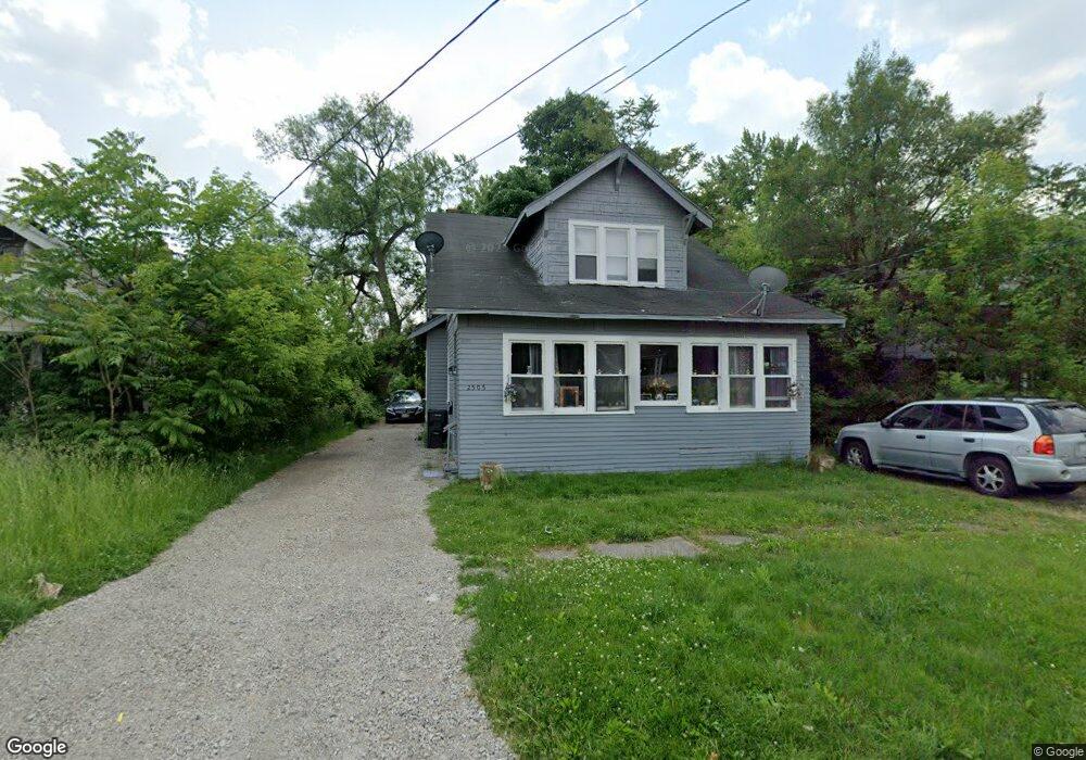
2505 Brown St Flint, MI 48503
Southwest Flint NeighborhoodEstimated Value: $63,000 - $94,000
4
Beds
3
Baths
1,571
Sq Ft
$47/Sq Ft
Est. Value
About This Home
This home is located at 2505 Brown St, Flint, MI 48503 and is currently estimated at $74,598, approximately $47 per square foot. 2505 Brown St is a home located in Genesee County with nearby schools including Eisenhower School, Flint Southwestern Classical Academy, and St. Paul Lutheran School.
Ownership History
Date
Name
Owned For
Owner Type
Purchase Details
Closed on
Jun 3, 2011
Sold by
Secretary Of Housing & Urban Development
Bought by
Henson Warren L
Current Estimated Value
Purchase Details
Closed on
Jan 28, 2011
Sold by
Federal National Mortgage Association
Bought by
Secretary Of Housing & Urban Development
Purchase Details
Closed on
Nov 24, 2010
Sold by
Mchale Harriet and Mchale James H
Bought by
Federal National Mortgage Association
Purchase Details
Closed on
Jun 5, 2002
Sold by
Mchale James Howard and Mchale Harriet June
Bought by
The James H & H June Mchale Revocable Li
Create a Home Valuation Report for This Property
The Home Valuation Report is an in-depth analysis detailing your home's value as well as a comparison with similar homes in the area
Home Values in the Area
Average Home Value in this Area
Purchase History
| Date | Buyer | Sale Price | Title Company |
|---|---|---|---|
| Henson Warren L | $6,000 | None Available | |
| Secretary Of Housing & Urban Development | -- | None Available | |
| Federal National Mortgage Association | $15,531 | None Available | |
| The James H & H June Mchale Revocable Li | -- | -- |
Source: Public Records
Tax History
| Year | Tax Paid | Tax Assessment Tax Assessment Total Assessment is a certain percentage of the fair market value that is determined by local assessors to be the total taxable value of land and additions on the property. | Land | Improvement |
|---|---|---|---|---|
| 2025 | $1,253 | $25,900 | $0 | $0 |
| 2024 | $1,178 | $25,900 | $0 | $0 |
| 2023 | $1,158 | $19,000 | $0 | $0 |
| 2022 | $0 | $16,400 | $0 | $0 |
| 2021 | $1,135 | $14,700 | $0 | $0 |
| 2020 | $1,059 | $13,200 | $0 | $0 |
| 2019 | $874 | $11,800 | $0 | $0 |
| 2018 | $1,009 | $12,100 | $0 | $0 |
| 2017 | $988 | $0 | $0 | $0 |
| 2016 | $982 | $0 | $0 | $0 |
| 2015 | -- | $0 | $0 | $0 |
| 2014 | -- | $0 | $0 | $0 |
| 2012 | -- | $12,000 | $0 | $0 |
Source: Public Records
Map
Nearby Homes
- 2537 Swayze St
- 2608 Cumings Ave
- 2433 Brown St
- 2429 Brown St
- 2618 Brown St
- 2509 Corunna Rd
- 2410 Corunna Rd
- 2464 Gibson St
- 2624 Miller Rd
- 2729 Chicago Blvd
- 2124 Swayze St
- 2437 Zimmerman St
- 1114 Clancy Ave
- 2112 Miller Rd
- 2830 Reynolds St
- 1725 Lincoln Dr
- 932 Bradley Ave
- 2663 W Court St
- 1202 Knapp Ave
- 1017 Stocker Ave
- 2509 Brown St
- 2501 Brown St
- 2513 Brown St
- 2517 Brown St
- 2506 Cumings Ave
- 2441 Brown St
- 2502 Cumings Ave
- 2514 Cumings Ave
- 2521 Brown St
- 2506 Brown St
- 2510 Brown St
- 2502 Brown St
- 2518 Cumings Ave
- 2437 Brown St
- 2514 Brown St
- 2418 Cumings Ave
- 2518 Brown St
- 2525 Brown St
- 2522 Cumings Ave
- 2414 Cumings Ave