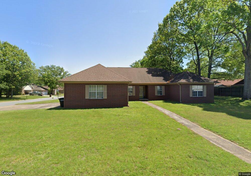
2506 Bearskin Dr Sherwood, AR 72120
Estimated Value: $251,000 - $279,000
3
Beds
2
Baths
1,717
Sq Ft
$153/Sq Ft
Est. Value
About This Home
This home is located at 2506 Bearskin Dr, Sherwood, AR 72120 and is currently estimated at $262,064, approximately $152 per square foot. 2506 Bearskin Dr is a home located in Pulaski County with nearby schools including Clinton Elementary School, Sylvan Hills Middle School, and Sylvan Hills High School.
Ownership History
Date
Name
Owned For
Owner Type
Purchase Details
Closed on
Mar 14, 2012
Sold by
Baker Tina M and Hermann Tina M
Bought by
Norris Nathan
Current Estimated Value
Home Financials for this Owner
Home Financials are based on the most recent Mortgage that was taken out on this home.
Original Mortgage
$126,400
Outstanding Balance
$86,952
Interest Rate
3.9%
Mortgage Type
New Conventional
Estimated Equity
$175,112
Purchase Details
Closed on
Oct 27, 2006
Sold by
Coons Arnold
Bought by
Hermann Tina M
Home Financials for this Owner
Home Financials are based on the most recent Mortgage that was taken out on this home.
Original Mortgage
$165,993
Interest Rate
6.37%
Mortgage Type
VA
Purchase Details
Closed on
Aug 26, 2003
Sold by
Coons Cheri
Bought by
Coons Arnold
Create a Home Valuation Report for This Property
The Home Valuation Report is an in-depth analysis detailing your home's value as well as a comparison with similar homes in the area
Home Values in the Area
Average Home Value in this Area
Purchase History
| Date | Buyer | Sale Price | Title Company |
|---|---|---|---|
| Norris Nathan | $158,000 | American Abstract & Title Co | |
| Hermann Tina M | $163,000 | American Abstract & Title Co | |
| Coons Arnold | -- | -- |
Source: Public Records
Mortgage History
| Date | Status | Borrower | Loan Amount |
|---|---|---|---|
| Open | Norris Nathan | $126,400 | |
| Previous Owner | Hermann Tina M | $165,993 |
Source: Public Records
Tax History Compared to Growth
Tax History
| Year | Tax Paid | Tax Assessment Tax Assessment Total Assessment is a certain percentage of the fair market value that is determined by local assessors to be the total taxable value of land and additions on the property. | Land | Improvement |
|---|---|---|---|---|
| 2025 | $2,179 | $42,718 | $5,800 | $36,918 |
| 2024 | $1,998 | $42,718 | $5,800 | $36,918 |
| 2023 | $1,998 | $42,718 | $5,800 | $36,918 |
| 2022 | $2,128 | $42,718 | $5,800 | $36,918 |
| 2021 | $1,982 | $34,860 | $6,030 | $28,830 |
| 2020 | $1,600 | $34,860 | $6,030 | $28,830 |
| 2019 | $1,600 | $34,860 | $6,030 | $28,830 |
| 2018 | $1,625 | $34,860 | $6,030 | $28,830 |
| 2017 | $1,625 | $34,860 | $6,030 | $28,830 |
| 2016 | $1,672 | $35,750 | $5,200 | $30,550 |
| 2015 | $1,816 | $35,750 | $5,200 | $30,550 |
| 2014 | $1,816 | $35,750 | $5,200 | $30,550 |
Source: Public Records
Map
Nearby Homes
- 201 Bearskin Dr
- 2226 Bearskin Dr
- 106 Winona Dr
- 2216 Sage Meadows Cir
- 7001 Park Meadows Dr
- 2125 Gap Creek Dr
- 796 Lake Tree Ln
- 7000 Park Meadows Dr
- 606 Bay View Ct
- 6901 Gap Point Cir
- 112 Sugar Maple Dr
- 7416 Glenn Hills Dr
- 6813 Gap Point Cir
- 2125 Glenn Arbor Ct
- 7112 E Ridge Dr
- 68 Shoshoni Dr
- 2708 Chert Cove
- 8340 Sapphire Cove
- 6608 Southshore Ln
- 8711 Cayuga Ln
- 103 Big Indian Dr
- 304 Tenkiller Dr
- 302 Tenkiller Dr
- 2422 Bearskin Dr
- 2507 Bearskin Dr
- 105 Big Indian Dr
- 2501 Bearskin Dr
- 300 Tenkiller Dr
- 104 Big Indian Dr
- 2423 Bearskin Dr
- 107 Big Indian Dr
- 119 Bearskin Dr
- 106 Big Indian Dr
- 204 Tenkiller Dr
- 2417 Bearskin Dr
- 114 Bearskin Dr
- 115 Horseshoe Dr
- 117 Bearskin Dr
- 2410 Bearskin Dr
- 108 Big Indian Dr