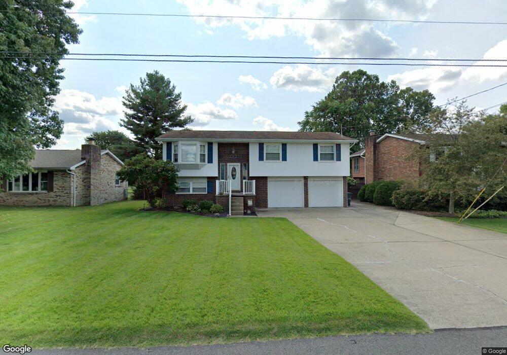
251 Doolin Dr Williamstown, WV 26187
Boaz NeighborhoodEstimated Value: $226,000 - $303,000
3
Beds
3
Baths
2,043
Sq Ft
$131/Sq Ft
Est. Value
About This Home
This home is located at 251 Doolin Dr, Williamstown, WV 26187 and is currently estimated at $267,839, approximately $131 per square foot. 251 Doolin Dr is a home located in Wood County with nearby schools including Williamstown Elementary School, Williamstown Middle/High School, and Wood County Christian School.
Ownership History
Date
Name
Owned For
Owner Type
Purchase Details
Closed on
Jul 25, 2007
Sold by
Handley Julie G and Handley Todd M
Bought by
Sandifer Robert S and Sandifer Eileen A
Current Estimated Value
Home Financials for this Owner
Home Financials are based on the most recent Mortgage that was taken out on this home.
Original Mortgage
$150,000
Outstanding Balance
$94,388
Interest Rate
6.72%
Mortgage Type
New Conventional
Estimated Equity
$173,451
Purchase Details
Closed on
Aug 3, 2006
Sold by
Handley Julie G and Tomer Julie G
Bought by
Handley Julie G and Handley Todd M
Home Financials for this Owner
Home Financials are based on the most recent Mortgage that was taken out on this home.
Original Mortgage
$50,000
Interest Rate
6.79%
Mortgage Type
Future Advance Clause Open End Mortgage
Create a Home Valuation Report for This Property
The Home Valuation Report is an in-depth analysis detailing your home's value as well as a comparison with similar homes in the area
Home Values in the Area
Average Home Value in this Area
Purchase History
| Date | Buyer | Sale Price | Title Company |
|---|---|---|---|
| Sandifer Robert S | $151,000 | None Available | |
| Handley Julie G | -- | None Available |
Source: Public Records
Mortgage History
| Date | Status | Borrower | Loan Amount |
|---|---|---|---|
| Open | Sandifer Robert S | $150,000 | |
| Previous Owner | Handley Julie G | $50,000 |
Source: Public Records
Tax History Compared to Growth
Tax History
| Year | Tax Paid | Tax Assessment Tax Assessment Total Assessment is a certain percentage of the fair market value that is determined by local assessors to be the total taxable value of land and additions on the property. | Land | Improvement |
|---|---|---|---|---|
| 2025 | $1,452 | $122,400 | $20,220 | $102,180 |
| 2024 | $1,452 | $115,980 | $19,740 | $96,240 |
| 2023 | $1,380 | $109,260 | $18,840 | $90,420 |
| 2022 | $1,172 | $106,200 | $17,880 | $88,320 |
| 2021 | $1,135 | $102,360 | $17,400 | $84,960 |
| 2020 | $1,114 | $100,080 | $17,400 | $82,680 |
| 2019 | $1,114 | $96,840 | $16,440 | $80,400 |
| 2018 | $1,118 | $94,500 | $15,300 | $79,200 |
| 2017 | $1,088 | $91,500 | $15,300 | $76,200 |
| 2016 | $990 | $89,760 | $15,300 | $74,460 |
| 2015 | $980 | $88,740 | $15,300 | $73,440 |
| 2014 | -- | $86,460 | $15,300 | $71,160 |
Source: Public Records
Map
Nearby Homes
- 0 Orange Dr
- 1097 Old River Rd
- 188 Greenbrier Ave
- 0 River Rd Unit Lot WP001
- 9 Henderson Ln
- 64 Alexander Dr
- 1371 N Dry Run Rd
- 6 Hunters Run
- 11 Silos
- 477 Burnt Hill Rd
- 375 Belavista Dr
- 603 Poplar Ave
- 2315 Blue Knob Rd
- 905 W 4th St
- 53 Central Dr
- 747 Virginia St
- 20 Silver Globe Rd
- 20043 State Route 550
- 1405 Greenmont Hills Dr
- 103 W 9th St