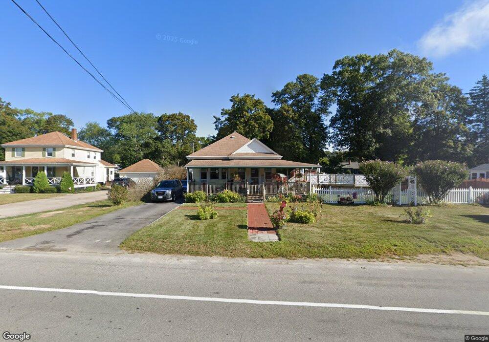
251 Long St Warwick, RI 02886
Nausauket NeighborhoodEstimated Value: $320,000 - $378,000
2
Beds
1
Bath
1,089
Sq Ft
$329/Sq Ft
Est. Value
About This Home
This home is located at 251 Long St, Warwick, RI 02886 and is currently estimated at $358,133, approximately $328 per square foot. 251 Long St is a home located in Kent County with nearby schools including St Rose Of Lima School and Eleanor Briggs School.
Ownership History
Date
Name
Owned For
Owner Type
Purchase Details
Closed on
Jun 11, 2020
Sold by
Marold Richard D and Marold Cheryl A
Bought by
Marold Richard D and Marold Cheryl A
Current Estimated Value
Purchase Details
Closed on
Aug 14, 2001
Sold by
Abosamara Ret Clarles and Abosamara Ret Angela
Bought by
Marold Richard D and Marold Cheryl A
Purchase Details
Closed on
Jul 15, 1999
Sold by
Dolan James J Est and Dolan
Bought by
Abosamra Charles A and Abosamra Angela
Create a Home Valuation Report for This Property
The Home Valuation Report is an in-depth analysis detailing your home's value as well as a comparison with similar homes in the area
Home Values in the Area
Average Home Value in this Area
Purchase History
| Date | Buyer | Sale Price | Title Company |
|---|---|---|---|
| Marold Richard D | -- | None Available | |
| Marold Richard D | $101,500 | -- | |
| Abosamra Charles A | $75,000 | -- |
Source: Public Records
Mortgage History
| Date | Status | Borrower | Loan Amount |
|---|---|---|---|
| Previous Owner | Abosamra Charles A | $82,616 | |
| Previous Owner | Abosamra Charles A | $182,500 | |
| Previous Owner | Abosamra Charles A | $120,000 | |
| Previous Owner | Abosamra Charles A | $20,000 |
Source: Public Records
Tax History Compared to Growth
Tax History
| Year | Tax Paid | Tax Assessment Tax Assessment Total Assessment is a certain percentage of the fair market value that is determined by local assessors to be the total taxable value of land and additions on the property. | Land | Improvement |
|---|---|---|---|---|
| 2024 | $3,632 | $251,000 | $98,100 | $152,900 |
| 2023 | $3,562 | $251,000 | $98,100 | $152,900 |
| 2022 | $3,546 | $189,300 | $75,400 | $113,900 |
| 2021 | $3,546 | $189,300 | $75,400 | $113,900 |
| 2020 | $3,506 | $187,200 | $73,300 | $113,900 |
| 2019 | $3,506 | $187,200 | $73,300 | $113,900 |
| 2018 | $3,151 | $151,500 | $73,300 | $78,200 |
| 2017 | $3,066 | $151,500 | $73,300 | $78,200 |
| 2016 | $3,066 | $151,500 | $73,300 | $78,200 |
| 2015 | $3,065 | $147,700 | $59,500 | $88,200 |
| 2014 | $2,963 | $147,700 | $59,500 | $88,200 |
| 2013 | $2,923 | $147,700 | $59,500 | $88,200 |
Source: Public Records
Map
Nearby Homes
- 9 Dunbar Ct
- 70 Helen Ave
- 132 Bakers Creek Rd
- 7 Cosett Rd
- 345 Nausauket Rd
- 3383 W Shore Rd
- 67 Oak Tree Ave
- 75 Capron Farm Dr
- 259 Buttonwoods Ave
- 325 Inez Ave
- 16 Arrow Ave
- 15 Anthony St
- 75 Marshall Ave
- 71 Macarthur Dr
- 60 Brunswick Dr
- 0 Capron Farm Dr
- 190 Capron Farm Dr
- 3539 W Shore Rd
- 66 Dory Rd
- 62 Red Maple Ln