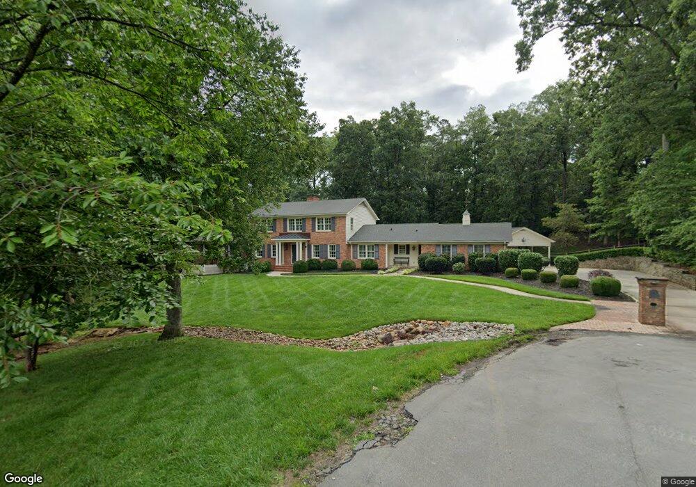
251 Ney Cir Davidson, NC 28036
Estimated Value: $1,318,000 - $1,845,392
5
Beds
4
Baths
4,642
Sq Ft
$346/Sq Ft
Est. Value
About This Home
This home is located at 251 Ney Cir, Davidson, NC 28036 and is currently estimated at $1,605,098, approximately $345 per square foot. 251 Ney Cir is a home located in Mecklenburg County with nearby schools including Davidson Elementary School, William Amos Hough High School, and Davidson Green School.
Ownership History
Date
Name
Owned For
Owner Type
Purchase Details
Closed on
Dec 17, 2001
Sold by
Grossi John V
Bought by
Edwards Robert W and Edwards Laney H
Current Estimated Value
Home Financials for this Owner
Home Financials are based on the most recent Mortgage that was taken out on this home.
Original Mortgage
$250,000
Outstanding Balance
$96,600
Interest Rate
6.42%
Estimated Equity
$1,508,498
Purchase Details
Closed on
Sep 22, 1997
Sold by
Grossi John V and Grossi Martha D
Bought by
Grossi John
Create a Home Valuation Report for This Property
The Home Valuation Report is an in-depth analysis detailing your home's value as well as a comparison with similar homes in the area
Home Values in the Area
Average Home Value in this Area
Purchase History
| Date | Buyer | Sale Price | Title Company |
|---|---|---|---|
| Edwards Robert W | $351,000 | -- | |
| Grossi John | -- | -- |
Source: Public Records
Mortgage History
| Date | Status | Borrower | Loan Amount |
|---|---|---|---|
| Open | Edwards Robert W | $250,000 |
Source: Public Records
Tax History
| Year | Tax Paid | Tax Assessment Tax Assessment Total Assessment is a certain percentage of the fair market value that is determined by local assessors to be the total taxable value of land and additions on the property. | Land | Improvement |
|---|---|---|---|---|
| 2025 | $9,375 | $1,244,900 | $609,700 | $635,200 |
| 2024 | $9,375 | $1,244,900 | $609,700 | $635,200 |
| 2023 | $9,246 | $1,244,900 | $609,700 | $635,200 |
| 2022 | $7,629 | $805,800 | $360,000 | $445,800 |
| 2021 | $7,548 | $805,800 | $360,000 | $445,800 |
| 2020 | $7,449 | $794,800 | $360,000 | $434,800 |
| 2019 | $7,443 | $794,800 | $360,000 | $434,800 |
| 2018 | $7,250 | $598,500 | $262,400 | $336,100 |
| 2017 | $7,202 | $598,500 | $262,400 | $336,100 |
| 2016 | $7,198 | $598,500 | $262,400 | $336,100 |
| 2015 | $7,195 | $601,200 | $262,400 | $338,800 |
| 2014 | $7,224 | $0 | $0 | $0 |
Source: Public Records
Map
Nearby Homes
- 720 Dogwood Ln
- 757 Concord Rd
- 130 Copper Pine Ln Unit 1
- 129 Hunt Camp Trail Unit 15
- 233 Twain Ave
- 866 Concord Rd
- 401 Woodland St
- 19104 Newburg Hill Rd
- 19035 Newburg Hill Rd
- 1016 Concord Rd
- 136 Spencer St
- 419 South St Unit 32
- 1916 Davis Rd
- 709 N Main St
- 216 Walnut St
- 324 Walnut St
- 229 Eden St
- 606 Ardrey Cir
- 110 Potts St
- 325 Goodrum St
- 243 Ney Cir
- 252 Ney Cir
- 242 Ney Cir
- 235 Ney Cir
- 236 Ney Cir
- 228 Roundway Down
- 225 Roundway Down Rd
- 212 Roundway Down
- 655 Dogwood Ln
- 641 Dogwood Ln
- 220 N Thompson St
- 647 Dogwood Ln
- 215 Ney Cir
- 659 Dogwood Ln
- 659 Dogwood Ln Unit 2
- 659 Dogwood Ln Unit B
- 659 Dogwood Ln Unit A
- 210 N Thompson St
- 221 N Thompson St
- 665 Dogwood Ln Unit B1
Your Personal Tour Guide
Ask me questions while you tour the home.