Estimated Value: $353,000 - $408,000
--
Bed
2
Baths
1,568
Sq Ft
$238/Sq Ft
Est. Value
About This Home
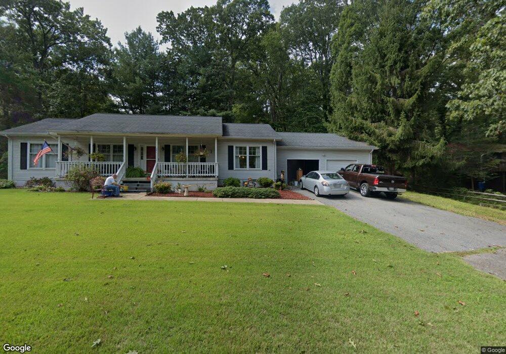
This home is located at 251 Pawnee Ln, Lusby, MD 20657 and is currently estimated at $373,929, approximately $238 per square foot. 251 Pawnee Ln is a home located in Calvert County with nearby schools including Patuxent Appeal Elementary Campus, Mill Creek Middle School, and Patuxent High School.
Ownership History
Date
Name
Owned For
Owner Type
Purchase Details
Closed on
Jun 27, 2001
Sold by
Davis Deborah A and Davis Brian K
Bought by
Humphreys Louie W and Humphreys Catherine A
Current Estimated Value
Purchase Details
Closed on
Nov 17, 1992
Sold by
Frisque Levi J and Frisque Marjorie D
Bought by
Davis Deborah A and Davis Brian K
Home Financials for this Owner
Home Financials are based on the most recent Mortgage that was taken out on this home.
Original Mortgage
$110,000
Interest Rate
8.32%
Purchase Details
Closed on
Sep 25, 1990
Sold by
Tsirigotis George P
Bought by
Frisque Levi J and Frisque Marjorie D
Create a Home Valuation Report for This Property
The Home Valuation Report is an in-depth analysis detailing your home's value as well as a comparison with similar homes in the area
Home Values in the Area
Average Home Value in this Area
Purchase History
| Date | Buyer | Sale Price | Title Company |
|---|---|---|---|
| Humphreys Louie W | $130,000 | -- | |
| Davis Deborah A | $117,000 | -- | |
| Frisque Levi J | $113,900 | -- |
Source: Public Records
Mortgage History
| Date | Status | Borrower | Loan Amount |
|---|---|---|---|
| Previous Owner | Davis Deborah A | $110,000 | |
| Closed | Humphreys Louie W | -- |
Source: Public Records
Tax History Compared to Growth
Tax History
| Year | Tax Paid | Tax Assessment Tax Assessment Total Assessment is a certain percentage of the fair market value that is determined by local assessors to be the total taxable value of land and additions on the property. | Land | Improvement |
|---|---|---|---|---|
| 2025 | $3,324 | $301,967 | $0 | $0 |
| 2024 | $3,324 | $272,833 | $0 | $0 |
| 2023 | $2,686 | $243,700 | $55,200 | $188,500 |
| 2022 | $2,443 | $235,133 | $0 | $0 |
| 2021 | $5,738 | $226,567 | $0 | $0 |
| 2020 | $172 | $218,000 | $55,200 | $162,800 |
| 2019 | $2,253 | $214,800 | $0 | $0 |
| 2018 | $2,220 | $211,600 | $0 | $0 |
| 2017 | $2,548 | $208,400 | $0 | $0 |
| 2016 | -- | $204,433 | $0 | $0 |
| 2015 | $2,826 | $200,467 | $0 | $0 |
| 2014 | $2,826 | $196,500 | $0 | $0 |
Source: Public Records
Map
Nearby Homes
- 11522 Buckskin Ct
- 228 Thunderbird Dr
- 232 Thunderbird Dr
- 291 Red Cloud Rd
- 285 Red Cloud Rd
- 11423 Rawhide Rd
- 11554 Durango Dr
- 11436 Stirrup Ln
- 513 Bridle Ct
- 11590 Durango Dr
- 11504 Durango Dr
- 11615 Big Bear Ln
- 11722 Big Bear Ln
- 11503 Ventura Trail
- 383 Red Cloud Rd
- 646 White Rock Rd
- 11525 Senora Ln
- 11609 Deadwood Dr
- 30 American Ln
- 10015 H G Trueman Rd
- 261 Pawnee Ln
- 248 Pawnee Ln
- 241 Pawnee Ln
- 11526 Lariat Ln
- 244 Pawnee Ln
- 264 Pawnee Ln
- 265 Pawnee Ln
- 252 Pawnee Ln
- 260 Pawnee Ln
- 11508 Lariat Ln
- 194 Thunderbird Dr
- 190 Thunderbird Dr
- 351 Chippewa Ln
- 269 Pawnee Ln
- 256 Pawnee Ln
- 11525 Buckskin Ct
- 345 Chippewa Ln
- 380 W Range Rd
- 12005 Taos Ct
- 11511 Lariat Ln