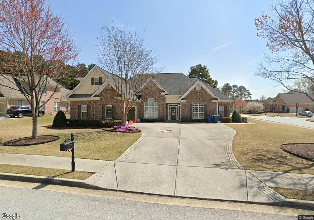
251 Starfire Ct Unit 2 Loganville, GA 30052
Estimated Value: $476,043 - $521,000
4
Beds
3
Baths
2,896
Sq Ft
$173/Sq Ft
Est. Value
About This Home
This home is located at 251 Starfire Ct Unit 2, Loganville, GA 30052 and is currently estimated at $500,511, approximately $172 per square foot. 251 Starfire Ct Unit 2 is a home located in Gwinnett County with nearby schools including Grayson Elementary School, Bay Creek Middle School, and Grayson High School.
Ownership History
Date
Name
Owned For
Owner Type
Purchase Details
Closed on
Jan 28, 2005
Sold by
Don Gale & Assocs Inc
Bought by
Britt Peegy S
Current Estimated Value
Purchase Details
Closed on
May 13, 2004
Sold by
Vintage Communities Inc
Bought by
Don Gale & Assocs Inc
Home Financials for this Owner
Home Financials are based on the most recent Mortgage that was taken out on this home.
Original Mortgage
$809,700
Interest Rate
5.77%
Mortgage Type
New Conventional
Create a Home Valuation Report for This Property
The Home Valuation Report is an in-depth analysis detailing your home's value as well as a comparison with similar homes in the area
Home Values in the Area
Average Home Value in this Area
Purchase History
| Date | Buyer | Sale Price | Title Company |
|---|---|---|---|
| Britt Peegy S | $269,900 | -- | |
| Don Gale & Assocs Inc | $210,000 | -- |
Source: Public Records
Mortgage History
| Date | Status | Borrower | Loan Amount |
|---|---|---|---|
| Previous Owner | Don Gale & Assocs Inc | $809,700 |
Source: Public Records
Tax History Compared to Growth
Tax History
| Year | Tax Paid | Tax Assessment Tax Assessment Total Assessment is a certain percentage of the fair market value that is determined by local assessors to be the total taxable value of land and additions on the property. | Land | Improvement |
|---|---|---|---|---|
| 2024 | $1,821 | $184,600 | $36,000 | $148,600 |
| 2023 | $1,821 | $177,040 | $44,800 | $132,240 |
| 2022 | $1,780 | $162,720 | $37,600 | $125,120 |
| 2021 | $1,765 | $122,880 | $25,600 | $97,280 |
| 2020 | $1,622 | $122,880 | $25,600 | $97,280 |
| 2019 | $1,622 | $122,880 | $25,600 | $97,280 |
| 2018 | $1,604 | $106,760 | $23,200 | $83,560 |
| 2016 | $1,512 | $96,120 | $18,080 | $78,040 |
| 2015 | $1,548 | $96,120 | $18,080 | $78,040 |
| 2014 | $1,313 | $77,800 | $12,000 | $65,800 |
Source: Public Records
Map
Nearby Homes
- 261 Starfire Ct
- 0 Starfire Ln Unit 7553477
- 0 Starfire Ln Unit 7039432
- 0 Starfire Ln Unit 7421735
- 0 Starfire Ln Unit 7003034
- 0 Starfire Ln Unit 3144975
- 0 Starfire Ln Unit 8640209
- 0 Starfire Ln Unit 8580350
- 0 Starfire Ln Unit 8486612
- 0 Starfire Ln Unit 8432453
- 0 Starfire Ln Unit 8239005
- 0 Starfire Ln Unit 8229842
- 0 Starfire Ln Unit 8208629
- 0 Starfire Ln Unit 8193239
- 0 Starfire Ln Unit 3250928
- 0 Starfire Ln Unit 8350325
- 0 Starfire Ln Unit 8199791
- 0 Starfire Ln Unit 7642134
- 2564 Starfire Ln
- 2564 Starfire Ln Unit 2564