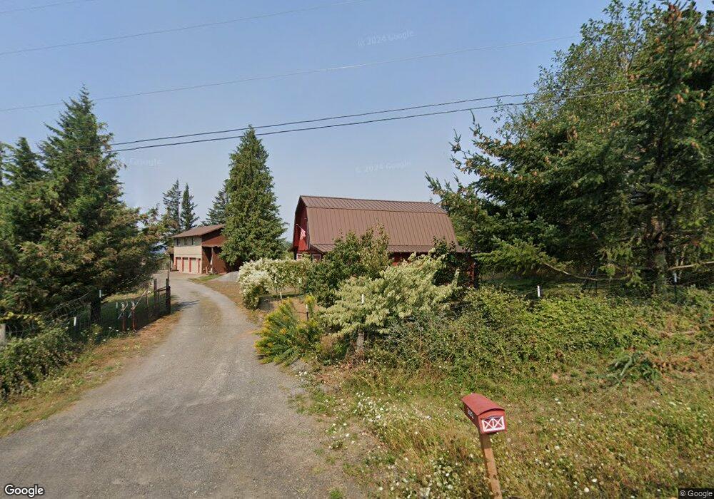
251 Strunk Rd Washougal, WA 98671
Estimated Value: $863,958 - $930,000
5
Beds
3
Baths
3,200
Sq Ft
$279/Sq Ft
Est. Value
About This Home
This home is located at 251 Strunk Rd, Washougal, WA 98671 and is currently estimated at $892,240, approximately $278 per square foot. 251 Strunk Rd is a home located in Skamania County with nearby schools including Mount Pleasant School.
Ownership History
Date
Name
Owned For
Owner Type
Purchase Details
Closed on
Jul 13, 2011
Sold by
Smith Randy K and Smith Grace
Bought by
Baker Dean C and Baker Sara M
Current Estimated Value
Home Financials for this Owner
Home Financials are based on the most recent Mortgage that was taken out on this home.
Original Mortgage
$276,800
Outstanding Balance
$190,340
Interest Rate
4.5%
Mortgage Type
New Conventional
Estimated Equity
$701,900
Purchase Details
Closed on
Apr 9, 2010
Sold by
Smith Randy Kayle and Smith Grace
Bought by
Smith Randy K and Smith Grace
Home Financials for this Owner
Home Financials are based on the most recent Mortgage that was taken out on this home.
Original Mortgage
$315,000
Interest Rate
4.95%
Mortgage Type
New Conventional
Create a Home Valuation Report for This Property
The Home Valuation Report is an in-depth analysis detailing your home's value as well as a comparison with similar homes in the area
Home Values in the Area
Average Home Value in this Area
Purchase History
| Date | Buyer | Sale Price | Title Company |
|---|---|---|---|
| Baker Dean C | $346,000 | County Title Company | |
| Smith Randy K | -- | Skamania County Title Compan |
Source: Public Records
Mortgage History
| Date | Status | Borrower | Loan Amount |
|---|---|---|---|
| Open | Baker Dean C | $276,800 | |
| Previous Owner | Smith Randy K | $315,000 |
Source: Public Records
Tax History Compared to Growth
Tax History
| Year | Tax Paid | Tax Assessment Tax Assessment Total Assessment is a certain percentage of the fair market value that is determined by local assessors to be the total taxable value of land and additions on the property. | Land | Improvement |
|---|---|---|---|---|
| 2025 | $5,043 | $643,000 | $287,500 | $355,500 |
| 2024 | $4,860 | $595,500 | $257,000 | $338,500 |
| 2023 | $4,609 | $523,600 | $217,000 | $306,600 |
| 2022 | $4,769 | $476,800 | $197,000 | $279,800 |
| 2021 | $4,648 | $451,400 | $182,000 | $269,400 |
| 2020 | $4,871 | $451,400 | $182,000 | $269,400 |
| 2019 | $3,618 | $386,100 | $144,400 | $241,700 |
| 2018 | $4,335 | $375,500 | $144,400 | $231,100 |
| 2017 | $4,132 | $376,800 | $133,000 | $243,800 |
| 2015 | $2,712 | $340,000 | $128,000 | $212,000 |
| 2013 | -- | $340,000 | $128,000 | $212,000 |
Source: Public Records
Map
Nearby Homes
- 0 Mt Pleasant Rd Unit tract 1 24567142
- 201 Kenco Rd
- 0 Wildlife Rd Unit 24581069
- 452 Wildlife Rd
- 32 Laurel Ln S
- 211 Skye Rd
- 47845 E Hist Columbia River Hwy
- 48025 E Historic Columbia River Hwy
- 48025 E Historic Columbia Ri Hwy
- 11 Thompson Dr
- 0 Thompson Drive Lot 3 Dr Unit Lot 3
- 0 Thompson Dr Unit Lot 3 11574678
- 0 Thompson Dr Unit Lot 3 408703892
- 00 Thompson Dr Unit Lot 3
- 1072 Labarre Rd
- 422 Stone Dr
- 281 Prindle Rd
- 232 Candy Ln
- 291 Blue Sky Dr
- 192 Karousel Ln Unit 1-3
- 501 Mount Pleasant Rd
- 232 Strunk Rd
- 51 Stardust Ln
- 671 Mt Pleasant Rd
- 371 Strunk Rd
- 381 Strunk Rd
- 112 Stardust Ln
- 431 Strunk Rd
- 701 Mt Pleasant Rd
- 471 Mt Pleasant Rd
- 281 Mt Zion Rd
- 352 Mt Pleasant Rd
- 62 Collins Rd
- 291 Mt Pleasant Rd
- 441 Strunk Rd
- 222 Mt Pleasant Rd
- 82 Grand View Ln
- 82 Grandview Ln
- 31 Grand View Ln
- 2491 Canyon Creek Rd