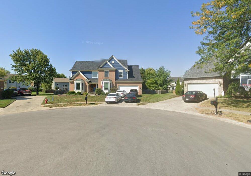
251 W Rowan Ct Westfield, IN 46074
Estimated Value: $483,000 - $545,000
4
Beds
3
Baths
3,543
Sq Ft
$148/Sq Ft
Est. Value
About This Home
This home is located at 251 W Rowan Ct, Westfield, IN 46074 and is currently estimated at $523,913, approximately $147 per square foot. 251 W Rowan Ct is a home located in Hamilton County with nearby schools including Shamrock Springs Elementary School, Westfield Intermediate School, and Westfield Middle School.
Ownership History
Date
Name
Owned For
Owner Type
Purchase Details
Closed on
Jun 23, 2006
Sold by
Cain Jeffrey M and Cain Kristen R
Bought by
Kukura Patrick J and Kukura Laura L
Current Estimated Value
Home Financials for this Owner
Home Financials are based on the most recent Mortgage that was taken out on this home.
Original Mortgage
$216,000
Outstanding Balance
$128,124
Interest Rate
6.73%
Mortgage Type
Purchase Money Mortgage
Estimated Equity
$395,789
Purchase Details
Closed on
Jun 10, 2003
Sold by
Higgs Carla and Higgs Paul N
Bought by
Cain Jeffrey M and Cain Kristin R
Home Financials for this Owner
Home Financials are based on the most recent Mortgage that was taken out on this home.
Original Mortgage
$229,900
Interest Rate
3.87%
Mortgage Type
Purchase Money Mortgage
Create a Home Valuation Report for This Property
The Home Valuation Report is an in-depth analysis detailing your home's value as well as a comparison with similar homes in the area
Home Values in the Area
Average Home Value in this Area
Purchase History
| Date | Buyer | Sale Price | Title Company |
|---|---|---|---|
| Kukura Patrick J | -- | None Available | |
| Cain Jeffrey M | -- | -- |
Source: Public Records
Mortgage History
| Date | Status | Borrower | Loan Amount |
|---|---|---|---|
| Open | Kukura Patrick J | $216,000 | |
| Previous Owner | Cain Jeffrey M | $229,900 |
Source: Public Records
Tax History Compared to Growth
Tax History
| Year | Tax Paid | Tax Assessment Tax Assessment Total Assessment is a certain percentage of the fair market value that is determined by local assessors to be the total taxable value of land and additions on the property. | Land | Improvement |
|---|---|---|---|---|
| 2024 | $4,966 | $458,800 | $59,100 | $399,700 |
| 2023 | $5,031 | $436,600 | $59,100 | $377,500 |
| 2022 | $4,621 | $392,200 | $59,100 | $333,100 |
| 2021 | $4,146 | $341,900 | $59,100 | $282,800 |
| 2020 | $4,062 | $331,800 | $59,100 | $272,700 |
| 2019 | $3,910 | $319,500 | $46,800 | $272,700 |
| 2018 | $3,652 | $298,500 | $46,800 | $251,700 |
| 2017 | $3,246 | $286,700 | $46,800 | $239,900 |
| 2016 | $3,073 | $271,400 | $46,800 | $224,600 |
| 2014 | $2,890 | $257,900 | $46,800 | $211,100 |
| 2013 | $2,890 | $249,300 | $46,800 | $202,500 |
Source: Public Records
Map
Nearby Homes
- 225 W Tansey Crossing
- 15409 Heath Cir
- 15429 Cornflower Ct
- 315 Mcintosh Ln
- 32 E Greyhound Pass
- 564 Zephyr Way
- 15657 Hush Hickory Bend
- 15564 Bethesda Cir
- 809 Stockbridge Dr
- 15706 Maybell Ln
- 15826 Buxton Dr
- 2175 Ryder Place
- 516 Viburnum Run
- 15865 W Rail Dr
- 221 Kerry Ct
- 255 Coatsville Dr
- 245 Coatsville Dr
- 30 Markleville Ln
- 693 Mcnamara Ct
- 1204 Middlebury Dr
- 250 W Rowan Ct
- 243 W Rowan Ct
- 361 W Tansey Crossing
- 369 W Tansey Crossing
- 377 W Tansey Crossing
- 385 W Tansey Crossing
- 353 W Tansey Crossing
- 242 W Rowan Ct
- 235 W Rowan Ct
- 337 W Tansey Crossing
- 313 W Tansey Crossing
- 391 W Tansey Crossing
- 305 W Tansey Crossing
- 234 W Rowan Ct
- 249 W Tansey Crossing
- 227 W Rowan Ct
- 397 W Tansey Crossing
- 226 W Rowan Ct
- 241 W Tansey Crossing
- 358 W Tansley Crossing