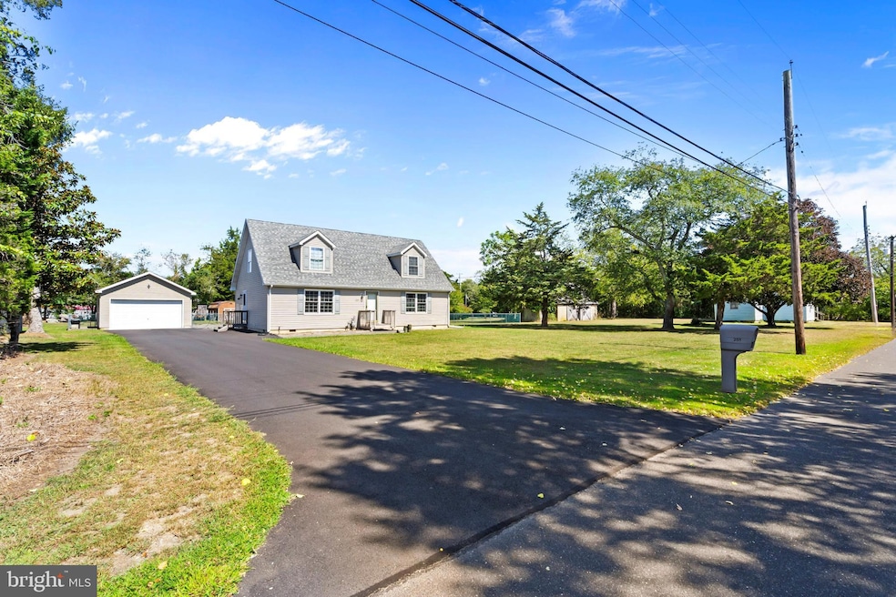
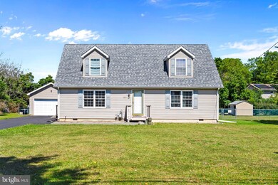
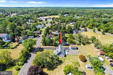
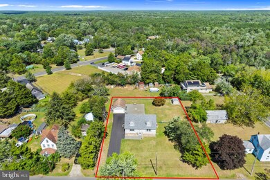
251 West St West Creek, NJ 08092
Eaglewood NeighborhoodEstimated payment $2,837/month
Highlights
- Cape Cod Architecture
- Main Floor Bedroom
- Bonus Room
- Deck
- Attic
- No HOA
About This Home
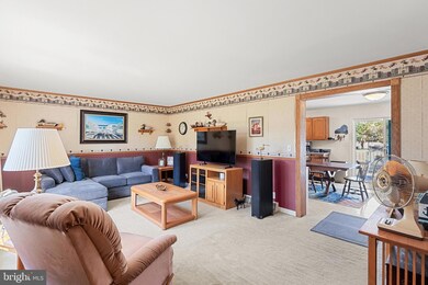
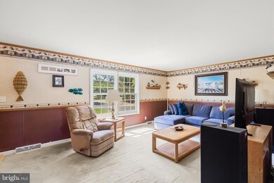
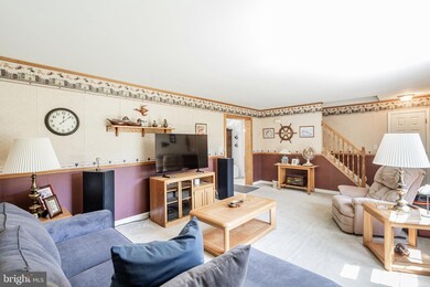
Cape with easy expansion possibility! Living room with archway to Large Eat in Country kitchen, 2 bedrooms, main bath & Laundry closet on 1st floor. 2nd floor bonus room and other half can be easily finished. Full bath with shower stall also on 2nd fl. Gentleman's detached 2 car garage with ample storage, separate side entrance door, and separate electric. New rear deck 2024, New roof 2022, New driveway 2024, Gas furnace 2011. Newer appliances. 135 x 170 Lot...Large fenced in rear yard, Storage shed, Private well and septic. Make this your own with decor updates to items like Liv Rm wall paper & carpet. This one is not to be missed. Nestled just blocks from Rte 9 &downtown area of West Creek / Eagleswood.
Listing Agent
(908) 337-4383 jhergert@actionplusrealty.com Better Homes and Gardens Real Estate Murphy & Co. Listed on: 09/06/2025

Home Details
Home Type
- Single Family
Est. Annual Taxes
- $6,211
Year Built
- Built in 2001
Lot Details
- 0.53 Acre Lot
- Lot Dimensions are 135 x 170
- Infill Lot
- Partially Fenced Property
- Level Lot
- Property is zoned R-3, R-3
Parking
- 2 Car Detached Garage
- Oversized Parking
- Parking Storage or Cabinetry
- Driveway
- Off-Street Parking
Home Design
- Cape Cod Architecture
- Shingle Roof
- Vinyl Siding
Interior Spaces
- 1,232 Sq Ft Home
- Property has 2 Levels
- Insulated Windows
- Double Hung Windows
- Sliding Doors
- Living Room
- Bonus Room
- Crawl Space
- Storm Doors
- Attic
Kitchen
- Electric Oven or Range
- Stove
- Built-In Microwave
- Dishwasher
Flooring
- Carpet
- Vinyl
Bedrooms and Bathrooms
- 2 Main Level Bedrooms
- Bathtub with Shower
Laundry
- Dryer
- Washer
Outdoor Features
- Deck
- Storage Shed
- Outbuilding
Utilities
- Forced Air Heating and Cooling System
- Well
- Electric Water Heater
- Septic Tank
Community Details
- No Home Owners Association
- West Creek Subdivision
Listing and Financial Details
- Tax Lot 00007 01
- Assessor Parcel Number 09-00021-0000-00007-01
Map
Home Values in the Area
Average Home Value in this Area
Tax History
| Year | Tax Paid | Tax Assessment Tax Assessment Total Assessment is a certain percentage of the fair market value that is determined by local assessors to be the total taxable value of land and additions on the property. | Land | Improvement |
|---|---|---|---|---|
| 2025 | $6,211 | $225,600 | $112,300 | $113,300 |
| 2024 | $6,186 | $225,600 | $112,300 | $113,300 |
| 2023 | $6,030 | $225,600 | $112,300 | $113,300 |
| 2022 | $6,030 | $225,600 | $112,300 | $113,300 |
| 2021 | $5,589 | $225,600 | $112,300 | $113,300 |
| 2020 | $6,118 | $225,600 | $112,300 | $113,300 |
| 2019 | $5,933 | $225,600 | $112,300 | $113,300 |
| 2018 | $5,534 | $225,600 | $112,300 | $113,300 |
| 2017 | $5,520 | $225,600 | $112,300 | $113,300 |
| 2016 | $5,338 | $225,600 | $112,300 | $113,300 |
| 2015 | $5,128 | $225,600 | $112,300 | $113,300 |
| 2014 | $4,959 | $225,600 | $112,300 | $113,300 |
Property History
| Date | Event | Price | List to Sale | Price per Sq Ft |
|---|---|---|---|---|
| 10/07/2025 10/07/25 | Pending | -- | -- | -- |
| 09/06/2025 09/06/25 | For Sale | $440,000 | -- | $357 / Sq Ft |
Purchase History
| Date | Type | Sale Price | Title Company |
|---|---|---|---|
| Bargain Sale Deed | $222,000 | Surety Title Agency Coastal |
Mortgage History
| Date | Status | Loan Amount | Loan Type |
|---|---|---|---|
| Open | $162,000 | Fannie Mae Freddie Mac |
Source: Bright MLS
MLS Number: NJOC2036892
APN: 09-00021-0000-00007-01
Disclaimer: Certain information contained herein is derived from information provided by parties other than Homes.com. All information provided is deemed reliable, but is not guaranteed to be accurate and should be independently verified.
![]() The data relating to real estate for sale on this website appears in part through the BRIGHT Internet Data Exchange program, a voluntary cooperative exchange of property listing data between licensed real estate brokerage firms, and is provided by BRIGHT through a licensing agreement.
The data relating to real estate for sale on this website appears in part through the BRIGHT Internet Data Exchange program, a voluntary cooperative exchange of property listing data between licensed real estate brokerage firms, and is provided by BRIGHT through a licensing agreement.
Listing information is from various brokers who participate in the Bright MLS IDX program and not all listings may be visible on the site.
The property information being provided on or through the website is for the personal, non-commercial use of consumers and such information may not be used for any purpose other than to identify prospective properties consumers may be interested in purchasing.
Some properties which appear for sale on the website may no longer be available because they are for instance, under contract, sold or are no longer being offered for sale.
Property information displayed is deemed reliable but is not guaranteed.
Copyright 2025 Bright MLS, Inc.