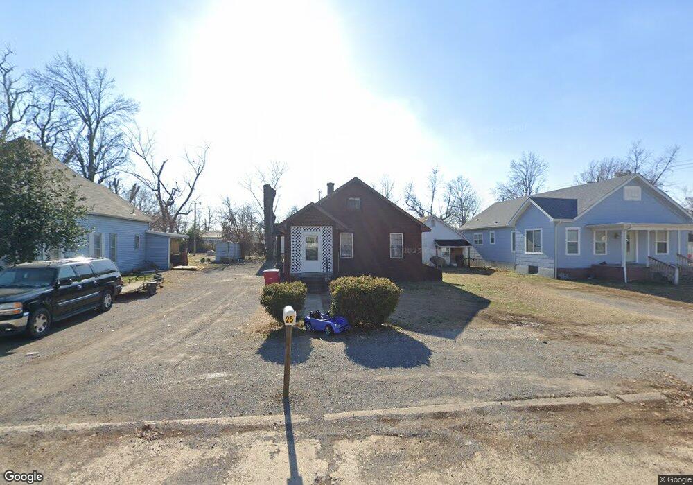
251 William St Sikeston, MO 63801
Estimated Value: $70,000 - $93,044
3
Beds
2
Baths
1,170
Sq Ft
$70/Sq Ft
Est. Value
About This Home
This home is located at 251 William St, Sikeston, MO 63801 and is currently estimated at $82,011, approximately $70 per square foot. 251 William St is a home with nearby schools including Sikeston Senior High School, The Christian Academy, and St. Francis Xavier School.
Ownership History
Date
Name
Owned For
Owner Type
Purchase Details
Closed on
Aug 24, 2023
Sold by
Farrar Richard and Howard Kimberly
Bought by
Applewhite Vella and Applewhite Derrick
Current Estimated Value
Purchase Details
Closed on
Apr 7, 2023
Sold by
Yant Family Revocable Trust
Bought by
Howard Kimberly and Farrar Richard
Purchase Details
Closed on
Mar 21, 2008
Sold by
Deutsche Bank National Trust Company
Bought by
Yant Randy and Yant Glenda Kay
Home Financials for this Owner
Home Financials are based on the most recent Mortgage that was taken out on this home.
Original Mortgage
$10,000
Interest Rate
6.19%
Create a Home Valuation Report for This Property
The Home Valuation Report is an in-depth analysis detailing your home's value as well as a comparison with similar homes in the area
Home Values in the Area
Average Home Value in this Area
Purchase History
| Date | Buyer | Sale Price | Title Company |
|---|---|---|---|
| Applewhite Vella | -- | None Listed On Document | |
| Applewhite Derrick | -- | -- | |
| Howard Kimberly | -- | None Listed On Document | |
| Yant Randy | -- | -- |
Source: Public Records
Mortgage History
| Date | Status | Borrower | Loan Amount |
|---|---|---|---|
| Previous Owner | Yant Randy | $10,000 |
Source: Public Records
Tax History Compared to Growth
Tax History
| Year | Tax Paid | Tax Assessment Tax Assessment Total Assessment is a certain percentage of the fair market value that is determined by local assessors to be the total taxable value of land and additions on the property. | Land | Improvement |
|---|---|---|---|---|
| 2025 | $242 | $5,660 | $0 | $0 |
| 2024 | $242 | $5,080 | $0 | $0 |
| 2023 | $241 | $5,080 | $0 | $0 |
| 2022 | $242 | $4,890 | $0 | $0 |
| 2021 | $241 | $4,890 | $0 | $0 |
| 2020 | $217 | $4,700 | $0 | $0 |
| 2019 | -- | $4,700 | $0 | $0 |
| 2018 | -- | $4,700 | $0 | $0 |
| 2017 | -- | $4,700 | $0 | $0 |
| 2014 | -- | $4,710 | $0 | $0 |
| 2011 | -- | $4,710 | $0 | $0 |
Source: Public Records
Map
Nearby Homes
- 119 William St
- 325 Daniel St
- 115 William St
- 102 Ruth St
- 512 S New Madrid St
- 406 W Gladys St
- 511 S Kingshighway St
- 417 S Kingshighway St
- 723 Kendall St
- 305 E Kathleen St
- 316 Edmondson St
- 318 E Gladys St
- 319 Benton St
- 321 Benton St
- 322 Helen St
- 114 W North St
- 338 E Gladys St
- 203 N Kingshighway St
- 334 E Kathleen St
- 800 Cotton Ridge Dr