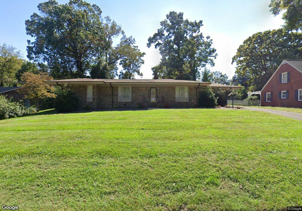
251 Wrenn Ave Mount Airy, NC 27030
Estimated Value: $252,080 - $299,000
2
Beds
2
Baths
1,781
Sq Ft
$155/Sq Ft
Est. Value
About This Home
This home is located at 251 Wrenn Ave, Mount Airy, NC 27030 and is currently estimated at $275,770, approximately $154 per square foot. 251 Wrenn Ave is a home located in Surry County with nearby schools including Bruce H. Tharrington Elementary School, Mount Airy Middle School, and Mount Airy High School.
Ownership History
Date
Name
Owned For
Owner Type
Purchase Details
Closed on
Jan 2, 2025
Sold by
Fitch Brown Barry and Pequeno Beth B
Bought by
Solomon Robert H and Solomon Elizabeth
Current Estimated Value
Home Financials for this Owner
Home Financials are based on the most recent Mortgage that was taken out on this home.
Original Mortgage
$185,000
Outstanding Balance
$183,559
Interest Rate
6.84%
Mortgage Type
New Conventional
Estimated Equity
$92,211
Purchase Details
Closed on
Mar 22, 2019
Sold by
Kallam Winston D and Kallam Karen L
Bought by
Fitch-Brown Barry and Pequeno Beth B
Purchase Details
Closed on
Dec 1, 1987
Purchase Details
Closed on
Dec 1, 1983
Purchase Details
Closed on
Nov 1, 1983
Purchase Details
Closed on
Oct 1, 1982
Create a Home Valuation Report for This Property
The Home Valuation Report is an in-depth analysis detailing your home's value as well as a comparison with similar homes in the area
Home Values in the Area
Average Home Value in this Area
Purchase History
| Date | Buyer | Sale Price | Title Company |
|---|---|---|---|
| Solomon Robert H | $275,000 | None Listed On Document | |
| Solomon Robert H | $275,000 | None Listed On Document | |
| Fitch-Brown Barry | $135,000 | -- | |
| -- | $71,700 | -- | |
| -- | $57,000 | -- | |
| -- | $56,700 | -- | |
| -- | $57,000 | -- |
Source: Public Records
Mortgage History
| Date | Status | Borrower | Loan Amount |
|---|---|---|---|
| Open | Solomon Robert H | $185,000 | |
| Closed | Solomon Robert H | $185,000 |
Source: Public Records
Tax History Compared to Growth
Tax History
| Year | Tax Paid | Tax Assessment Tax Assessment Total Assessment is a certain percentage of the fair market value that is determined by local assessors to be the total taxable value of land and additions on the property. | Land | Improvement |
|---|---|---|---|---|
| 2025 | $1,141 | $187,880 | $31,500 | $156,380 |
| 2024 | $528 | $145,190 | $31,500 | $113,690 |
| 2023 | $801 | $145,190 | $31,500 | $113,690 |
| 2022 | $989 | $145,190 | $31,500 | $113,690 |
| 2021 | $1,005 | $145,190 | $31,500 | $113,690 |
| 2020 | $1,037 | $143,320 | $31,500 | $111,820 |
| 2019 | $995 | $143,320 | $31,500 | $111,820 |
| 2018 | $979 | $137,680 | $0 | $0 |
| 2017 | $992 | $137,680 | $0 | $0 |
| 2016 | $978 | $137,680 | $0 | $0 |
| 2013 | -- | $135,500 | $0 | $0 |
Source: Public Records
Map
Nearby Homes
- 109 Grace St
- 1709 N Main St Unit A-1
- 1709 N Main St
- 316 Linville Rd
- 344 Linville Rd
- TBD River Walk Rd
- 234 Hylton St
- 2029 N Main St
- 311 E Lebanon St
- 0 Woodruff St
- 1694 Woodbury Ln
- 921 N South St
- 150 Witt St
- 1816 Gwyn St
- 1020 Frank St
- 648 Knollwood Dr
- 607 Riverside Dr
- 712 Greenhill Rd
- 643 Willow St
- 1769 Inglebrook Trail