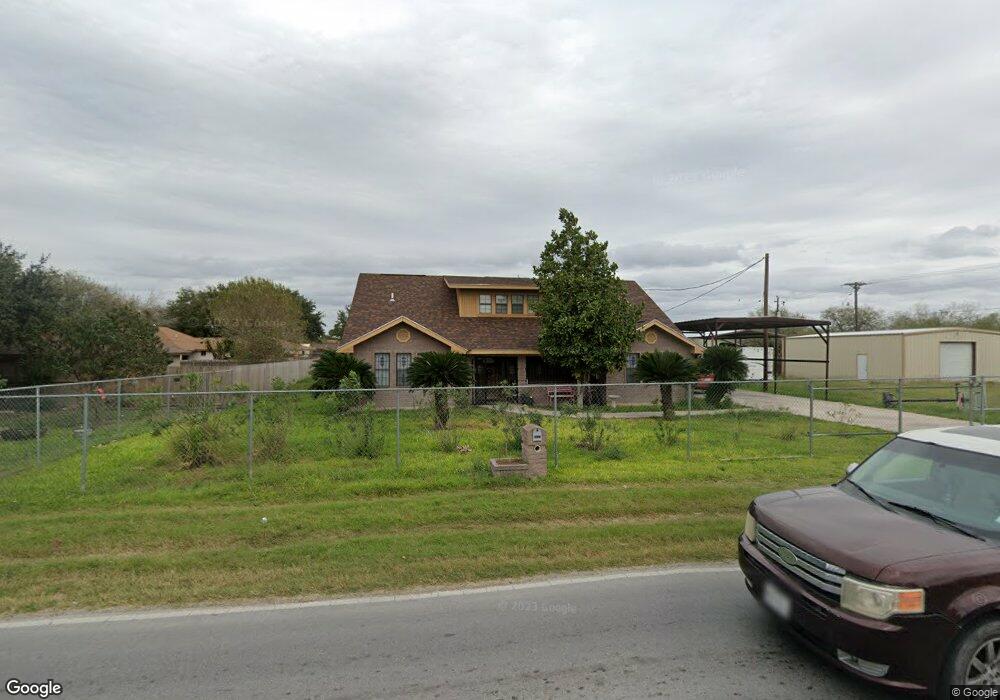
2512 W Mile 10 N Weslaco, TX 78599
Estimated Value: $240,000 - $332,000
4
Beds
2
Baths
2,340
Sq Ft
$118/Sq Ft
Est. Value
About This Home
This home is located at 2512 W Mile 10 N, Weslaco, TX 78599 and is currently estimated at $276,853, approximately $118 per square foot. 2512 W Mile 10 N is a home with nearby schools including Rodolfo Rudy Silva Jr. Elementary School, Beatriz G. Garza Middle School, and Weslaco High School.
Ownership History
Date
Name
Owned For
Owner Type
Purchase Details
Closed on
Jul 13, 2019
Sold by
Alvarado Maria Isabel and Balsaldua Maria Isabel
Bought by
Alvarado Maria Isabel and Alvarado Carlos
Current Estimated Value
Home Financials for this Owner
Home Financials are based on the most recent Mortgage that was taken out on this home.
Original Mortgage
$96,000
Outstanding Balance
$88,925
Interest Rate
3.82%
Mortgage Type
Credit Line Revolving
Estimated Equity
$187,928
Purchase Details
Closed on
Mar 26, 1997
Sold by
Davila Armando J Yolanda Davila
Bought by
Basaldua Maria Isabel
Create a Home Valuation Report for This Property
The Home Valuation Report is an in-depth analysis detailing your home's value as well as a comparison with similar homes in the area
Home Values in the Area
Average Home Value in this Area
Purchase History
| Date | Buyer | Sale Price | Title Company |
|---|---|---|---|
| Alvarado Maria Isabel | -- | None Available | |
| Basaldua Maria Isabel | -- | -- |
Source: Public Records
Mortgage History
| Date | Status | Borrower | Loan Amount |
|---|---|---|---|
| Open | Alvarado Maria Isabel | $96,000 |
Source: Public Records
Tax History Compared to Growth
Tax History
| Year | Tax Paid | Tax Assessment Tax Assessment Total Assessment is a certain percentage of the fair market value that is determined by local assessors to be the total taxable value of land and additions on the property. | Land | Improvement |
|---|---|---|---|---|
| 2025 | $2,548 | $205,388 | -- | -- |
| 2024 | $2,548 | $186,716 | $49,470 | $137,246 |
| 2023 | $3,166 | $170,445 | $0 | $0 |
| 2022 | $2,916 | $154,950 | $0 | $0 |
| 2021 | $2,708 | $140,864 | $34,920 | $105,944 |
| 2020 | $2,647 | $132,924 | $34,920 | $98,004 |
| 2019 | $2,637 | $126,715 | $34,920 | $91,795 |
| 2018 | $2,667 | $127,819 | $34,920 | $92,899 |
| 2017 | $2,680 | $128,922 | $34,920 | $94,002 |
| 2016 | $2,551 | $122,681 | $23,280 | $99,401 |
| 2015 | $2,173 | $123,838 | $23,280 | $100,558 |
| 2014 | $2,173 | $112,889 | $23,280 | $89,609 |
Source: Public Records
Map
Nearby Homes
- 3009 Fletcher St
- 2831 Sienna Dr
- 2657 Sienna Dr
- 2916 Fletcher St
- 3523 Mile 6 1 2 W
- 2321 Cardinal Dr
- 2121 Cardinal Dr
- 2212 Zinnia St
- 2300 Zinnia St
- 2220 Zinnia St
- 2216 Zinnia St
- 2125 Zinnia St
- 2124 Zinnia St
- 2305 Cardinal Dr
- 2301 Cardinal Dr
- 2125 Cardinal Dr
- 2201 Cardinal Dr
- 2109 Cardinal Dr
- 2221 Cardinal Dr
- 2112 Blue Sky Dr
- 2518 W Mile 10 N
- 6 1/2 W Mile 10 N
- 2511 Alabama St
- 2604 W Mile 10 N
- 530A Rr 6
- 2605 Alabama St
- 2516 Alabama St
- 2512 Alabama St
- 2508 Alabama St
- 2612 W Mile 10 N
- 2606 Alabama St
- 2505 California St
- 2517 California St
- 2607 California St
- 2704 W Mile 10 N
- 2613 California St
- 2518 California St
- 2514 California St
- 2522 California St
- 2510 California St