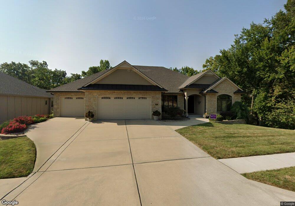
2513 NW Ashurst Dr Lees Summit, MO 64081
Lee's Summit AreaEstimated Value: $651,000 - $808,000
About This Home
This home is located at 2513 NW Ashurst Dr, Lees Summit, MO 64081 and is currently estimated at $733,871, approximately $241 per square foot. 2513 NW Ashurst Dr is a home with nearby schools including Cedar Creek Elementary School, Pleasant Lea Middle School, and Lee's Summit Senior High School.
Ownership History
We collect this data history from publicly available records. To have your information removed, we recommend requesting removal directly through your county’s website.
Purchase Details
Purchase Details
Purchase Details
Home Financials for this Owner
Home Financials are based on the most recent Mortgage that was taken out on this home.Purchase Details
Home Values in the Area
Average Home Value in this Area
Purchase History
We collect this data history from publicly available records. To have your information removed, we recommend requesting removal directly through your county’s website.
| Date | Buyer | Sale Price | Title Company |
|---|---|---|---|
| $785,000 | Chicago Title | ||
| -- | None Available | ||
| -- | Coffelt Land Title Inc | ||
| -- | None Available |
Mortgage History
We collect this data history from publicly available records. To have your information removed, we recommend requesting removal directly through your county’s website.
| Date | Status | Borrower | Loan Amount |
|---|---|---|---|
| Previous Owner | $385,000 |
Tax History
We collect this data history from publicly available records. To have your information removed, we recommend requesting removal directly through your county’s website.
| Year | Tax Paid | Tax Assessment Tax Assessment Total Assessment is a certain percentage of the fair market value that is determined by local assessors to be the total taxable value of land and additions on the property. | Land | Improvement |
|---|---|---|---|---|
| 2025 | $10,206 | $121,617 | $11,045 | $110,572 |
| 2024 | $10,206 | $141,341 | $13,870 | $127,471 |
| 2023 | $10,132 | $141,341 | $17,106 | $124,235 |
| 2022 | $7,423 | $91,960 | $12,167 | $79,793 |
| 2021 | $7,577 | $91,960 | $12,167 | $79,793 |
| 2020 | $7,285 | $87,551 | $12,167 | $75,384 |
| 2019 | $7,086 | $87,551 | $12,167 | $75,384 |
| 2018 | $6,645 | $76,197 | $10,589 | $65,608 |
| 2017 | $6,665 | $76,197 | $10,589 | $65,608 |
| 2016 | $6,665 | $75,639 | $10,146 | $65,493 |
| 2014 | $6,575 | $73,150 | $9,481 | $63,669 |
Map
- 510 NW Ashurst Place
- 469 NW Riven Rock Place
- 341 NW Thoreau Cir
- 627 NW Timberbrooke Dr
- 336 NW Thoreau Cir
- 301 NW Rockhill Cir
- 324 NW Thoreau Cir
- 105 NW Ambersham Dr
- 400 NW Tennyson Place
- 2508 NW Bent Tree Cir
- 3121 SW Merriam Dr
- 833 NW High Point Dr
- 202 NW Joshua Dr
- 2702 NW Cedar Brook
- 2452 NW Valley View Dr
- 2448 NW Valley View Dr
- 129 NW Morton Dr
- 1056 NW High Point Dr
- 2074 NW O'Brien Rd
- 433 NW Kaylea Ct
- 2509 NW Ashurst Dr
- 2599 NW Ashurst Dr
- 2507 NW Ashurst Dr
- 489 NW Riven Rock Trail
- 2505 NW Ashurst Dr
- 2510 NW Ashurst Dr
- 2506 NW Ashurst Dr
- 485 NW Riven Rock Trail
- 593 NW Riven Rock Trail
- 2508 NW Ashurst Dr
- 2503 NW Ashurst Dr
- 500 NW Ashurst Place
- 502 NW Ashurst Place
- 2501 NW Ashurst Dr
- 481 NW Riven Rock Trail
- 504 NW Ashurst Place
- 597 NW Riven Rock Trail
- 505 NW Westvale Cir
- 505 NW Westvale Cir Unit A
- 2605 NW Ashurst Ln
Ask me questions while you tour the home.