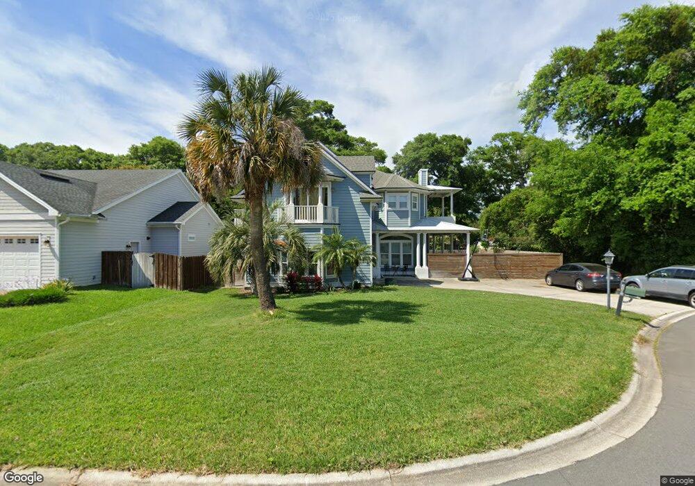
2513 Safe Harbor Ln Fernandina Beach, FL 32034
Estimated Value: $792,000 - $1,024,000
5
Beds
4
Baths
3,018
Sq Ft
$314/Sq Ft
Est. Value
About This Home
This home is located at 2513 Safe Harbor Ln, Fernandina Beach, FL 32034 and is currently estimated at $949,150, approximately $314 per square foot. 2513 Safe Harbor Ln is a home located in Nassau County with nearby schools including Southside Elementary School, Emma Love Hardee Elementary School, and Fernandina Beach Middle School.
Ownership History
Date
Name
Owned For
Owner Type
Purchase Details
Closed on
Sep 27, 2019
Sold by
Bottoff Andrew J
Bought by
Bottorff Phyllis D
Current Estimated Value
Purchase Details
Closed on
Mar 25, 2003
Sold by
Sandcastle Innovation Inc
Bought by
Bottorff Andrew J and Bottorff Phyllis D
Home Financials for this Owner
Home Financials are based on the most recent Mortgage that was taken out on this home.
Original Mortgage
$50,400
Interest Rate
5.5%
Create a Home Valuation Report for This Property
The Home Valuation Report is an in-depth analysis detailing your home's value as well as a comparison with similar homes in the area
Home Values in the Area
Average Home Value in this Area
Purchase History
| Date | Buyer | Sale Price | Title Company |
|---|---|---|---|
| Bottorff Phyllis D | -- | None Available | |
| Bottorff Andrew J | $56,000 | First American Title Ins Co |
Source: Public Records
Mortgage History
| Date | Status | Borrower | Loan Amount |
|---|---|---|---|
| Closed | Bottorff Andrew J | $50,400 |
Source: Public Records
Tax History Compared to Growth
Tax History
| Year | Tax Paid | Tax Assessment Tax Assessment Total Assessment is a certain percentage of the fair market value that is determined by local assessors to be the total taxable value of land and additions on the property. | Land | Improvement |
|---|---|---|---|---|
| 2024 | $5,967 | $369,675 | -- | -- |
| 2023 | $5,967 | $358,908 | $0 | $0 |
| 2022 | $5,623 | $348,454 | $0 | $0 |
| 2021 | $5,628 | $338,305 | $0 | $0 |
| 2020 | $5,681 | $333,634 | $0 | $0 |
| 2019 | $5,843 | $326,133 | $0 | $0 |
| 2018 | $5,647 | $320,052 | $0 | $0 |
| 2017 | $5,416 | $313,469 | $0 | $0 |
| 2016 | $5,374 | $307,022 | $0 | $0 |
| 2015 | $5,406 | $304,888 | $0 | $0 |
| 2014 | $5,394 | $302,468 | $0 | $0 |
Source: Public Records
Map
Nearby Homes
- 2552 Pirates Bay Dr
- 2490 Captain Hook Dr
- 2583 Forest Ridge Dr Unit 3
- 2133 Taurus Ct
- 2588 Forest Ridge Dr Unit N-8
- 2563 Forest Ridge Dr Unit P3
- 2696 Forest Ridge Dr Unit A6
- 2625 Long Boat Dr
- 2723 Forest Ridge Dr Unit K3
- 2657 Long Boat Dr
- 2666 Long Boat Dr
- 2888 Forest Ridge Dr Unit U-8
- 127 High Rigger Dr
- 2774 Forest Ridge Dr Unit F4
- LOT 36 Pirates Bay Dr
- 2105 Purcell Dr
- 2191 High Rigger Place
- 2700 Mizell Ave Unit 504A
- 2700 Mizell Ave Unit 403A
- 2700 Mizell Ave Unit 203B
- 2481 Safe Harbor Ln
- 2561 Pirates Bay Dr
- 2549 Pirates Bay Dr
- 2573 Pirates Bay Dr
- 2537 Pirates Bay Dr
- 2504 Safe Harbor Ln
- 2522 Safe Harbor Ln
- 2401 Safe Harbor Ln
- 2525 Pirates Bay Dr
- 2585 Pirates Bay Dr
- 2410 Safe Harbor Ln
- 2367 Safe Harbor Ln
- 2513 Pirates Bay Dr
- 2487 Captain Hook Dr
- 2512 Le Sabre Place
- 2576 Pirates Bay Dr
- 2398 Safe Harbor Ln
- 2507 Le Sabre Place
- 2457 Safe Harbor Ln
- 2597 Pirates Bay Dr