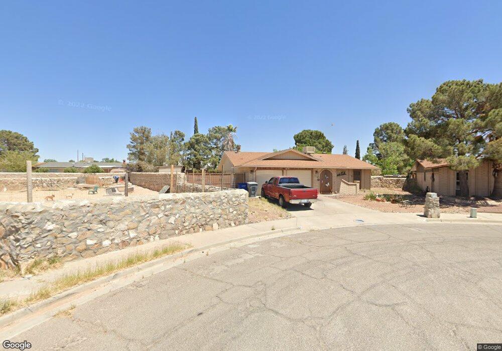
2516 Sea Palm Dr El Paso, TX 79936
Glen Cove NeighborhoodEstimated Value: $203,000 - $237,000
3
Beds
2
Baths
1,353
Sq Ft
$162/Sq Ft
Est. Value
About This Home
This home is located at 2516 Sea Palm Dr, El Paso, TX 79936 and is currently estimated at $219,853, approximately $162 per square foot. 2516 Sea Palm Dr is a home located in El Paso County with nearby schools including Glen Cove Elementary School, J.M. Hanks Middle School, and J M Hanks High School.
Ownership History
Date
Name
Owned For
Owner Type
Purchase Details
Closed on
Nov 11, 2009
Sold by
Wilson Paul D
Bought by
Wilson Paul D
Current Estimated Value
Purchase Details
Closed on
Oct 3, 2003
Sold by
Oppliger Daniel F and Oppliger Shirley
Bought by
Wilson Paul D and Wilson Barbara A
Home Financials for this Owner
Home Financials are based on the most recent Mortgage that was taken out on this home.
Original Mortgage
$66,400
Outstanding Balance
$31,432
Interest Rate
6.42%
Mortgage Type
Purchase Money Mortgage
Estimated Equity
$188,421
Create a Home Valuation Report for This Property
The Home Valuation Report is an in-depth analysis detailing your home's value as well as a comparison with similar homes in the area
Home Values in the Area
Average Home Value in this Area
Purchase History
| Date | Buyer | Sale Price | Title Company |
|---|---|---|---|
| Wilson Paul D | -- | None Available | |
| Wilson Paul D | -- | -- |
Source: Public Records
Mortgage History
| Date | Status | Borrower | Loan Amount |
|---|---|---|---|
| Open | Wilson Paul D | $66,400 |
Source: Public Records
Tax History Compared to Growth
Tax History
| Year | Tax Paid | Tax Assessment Tax Assessment Total Assessment is a certain percentage of the fair market value that is determined by local assessors to be the total taxable value of land and additions on the property. | Land | Improvement |
|---|---|---|---|---|
| 2025 | $5,511 | $216,556 | $37,248 | $179,308 |
| 2024 | $5,511 | $200,650 | $21,342 | $179,308 |
| 2023 | $5,598 | $192,347 | $21,342 | $171,005 |
| 2022 | $5,067 | $163,180 | $21,342 | $141,838 |
| 2021 | $4,676 | $143,864 | $21,342 | $122,522 |
| 2020 | $3,611 | $114,333 | $17,895 | $96,438 |
| 2018 | $3,563 | $114,583 | $17,895 | $96,688 |
| 2017 | $3,254 | $106,447 | $17,895 | $88,552 |
| 2016 | $3,254 | $106,447 | $17,895 | $88,552 |
| 2015 | $2,034 | $106,447 | $17,895 | $88,552 |
| 2014 | $2,034 | $106,028 | $17,895 | $88,133 |
Source: Public Records
Map
Nearby Homes
- 11201 Skipper Dr
- 11276 Skipper Dr
- 2348 Sea Side Dr
- 2612 Lake Victoria Dr
- 2624 Lake Victoria Dr
- 11132 Wharf Cove Dr
- 2604 Anise Dr
- 2101 E Glen Dr
- 11129 Nautical Dr
- 2308 Tom Watson Ct
- 2825 Wong Place Unit A/D
- 11237 Pony Soldier Ave
- 2913 Lake Champlain St
- 11445 David Carrasco Dr
- 1913 Seagull Dr
- 11345 Patricia Ave
- 11349 Patricia Ave
- 2600 Lake Michigan Dr
- 3121 Red Sails Dr
- 11008 Johnny Miller Dr
- 2512 Sea Palm Dr
- 2513 Rudder Place
- 2517 Rudder Place
- 2520 Sea Palm Dr
- 2509 Rudder Place
- 2521 Rudder Place
- 2524 Sea Palm Dr
- 2508 Sea Palm Dr
- 2505 Rudder Place
- 11217 Sea Horse Dr
- 2525 Rudder Place
- 11213 Sea Horse Dr
- 2528 Sea Palm Dr
- 11209 Sea Horse Dr
- 2501 Rudder Place
- 2501 Rudder Place
- 2504 Sea Palm Dr
- 2512 Rudder Place
- 2516 Rudder Place
- 2508 Rudder Place Unit 4