M
Landlord's Agent in 2026
Marc Miller
VYBE Realty
(443) 622-3973
40 Total Sales

Estimated Value: $147,000 - $147,418
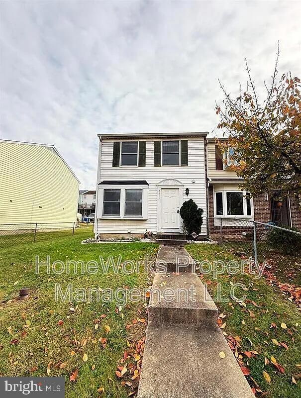
Experience the charm of 2517 South Paca Street where warmth and comfort fill every corner. The glow of polished hardwood floors welcomes you into a spacious living and dining area that invites gatherings and quiet evenings alike. Plush carpeting in the bedrooms brings a sense of softness underfoot, creating the perfect retreat after a long day. In the kitchen, the gentle hum of modern appliances, from the range oven and refrigerator to the microwave and dishwasher, sets the tone for effortless meal preparation. Generous cabinet space keeps everything neatly organized, making cooking a true pleasure. The partially finished basement, complete with a washer and dryer, adds both convenience and versatility to your home life. Move outdoors and enjoy the openness of a large front and backyard. Ideal for fresh air, morning routines, or simply relaxing under the open sky. **We require all residents to maintain renter's insurance. For added convenience, we also offer a Resident Benefits Package, which includes renter's insurance for those who do not have their own policy. **Pet Policy Notice: Please note that the pet policy for this property differs from our standard terms. Monthly Pet Rent: $50 per pet
Pet Deposit: $250 per pet All other terms of the standard pet policy remain in effect.
Last Agent to Rent the Property
(410) 220-4648 davids@justvybe.com VYBE Realty Listed on: 12/14/2025

Last Renter's Agent
(844) 552-7444 datacorrect@brightmls.com Non Subscribing Office License #0225194075
| Date | Buyer | Sale Price | Title Company |
|---|---|---|---|
| Richardson Towanda B | $29,500 | -- | |
| Richardson Towanda B | $29,500 | -- | |
| Brown Towanda L | $65,000 | -- |
| Date | Status | Borrower | Loan Amount |
|---|---|---|---|
| Previous Owner | Brown Towanda L | $65,000 |
| Date | Event | Price | List to Sale | Price per Sq Ft |
|---|---|---|---|---|
| 01/06/2026 01/06/26 | Rented | $1,699 | -10.5% | -- |
| 12/14/2025 12/14/25 | For Rent | $1,899 | -- | -- |
| Year | Tax Paid | Tax Assessment Tax Assessment Total Assessment is a certain percentage of the fair market value that is determined by local assessors to be the total taxable value of land and additions on the property. | Land | Improvement |
|---|---|---|---|---|
| 2025 | $2,719 | $126,133 | -- | -- |
| 2024 | $2,719 | $115,767 | -- | -- |
| 2023 | $2,487 | $105,400 | $10,000 | $95,400 |
| 2022 | $2,287 | $96,900 | $0 | $0 |
| 2021 | $2,086 | $88,400 | $0 | $0 |
| 2020 | $1,688 | $79,900 | $10,000 | $69,900 |
| 2019 | $1,679 | $79,900 | $10,000 | $69,900 |
| 2018 | $1,711 | $79,900 | $10,000 | $69,900 |
| 2017 | $2,926 | $131,500 | $0 | $0 |
| 2016 | $1,835 | $128,533 | $0 | $0 |
| 2015 | $1,835 | $125,567 | $0 | $0 |
| 2014 | $1,835 | $122,600 | $0 | $0 |
M
Landlord's Agent in 2026
Marc Miller
VYBE Realty
(443) 622-3973
40 Total Sales
d
Tenant's Agent in 2026
datacorrect BrightMLS
Non Subscribing Office
Source: Bright MLS
MLS Number: MDBA2195068
APN: 7474-015
Disclaimer: Certain information contained herein is derived from information provided by parties other than Homes.com. All information provided is deemed reliable, but is not guaranteed to be accurate and should be independently verified.
![]() The data relating to real estate for sale on this website appears in part through the BRIGHT Internet Data Exchange program, a voluntary cooperative exchange of property listing data between licensed real estate brokerage firms, and is provided by BRIGHT through a licensing agreement.
The data relating to real estate for sale on this website appears in part through the BRIGHT Internet Data Exchange program, a voluntary cooperative exchange of property listing data between licensed real estate brokerage firms, and is provided by BRIGHT through a licensing agreement.
Listing information is from various brokers who participate in the Bright MLS IDX program and not all listings may be visible on the site.
The property information being provided on or through the website is for the personal, non-commercial use of consumers and such information may not be used for any purpose other than to identify prospective properties consumers may be interested in purchasing.
Some properties which appear for sale on the website may no longer be available because they are for instance, under contract, sold or are no longer being offered for sale.
Property information displayed is deemed reliable but is not guaranteed.
Copyright 2026 Bright MLS, Inc.
Ask me questions while you tour the home.