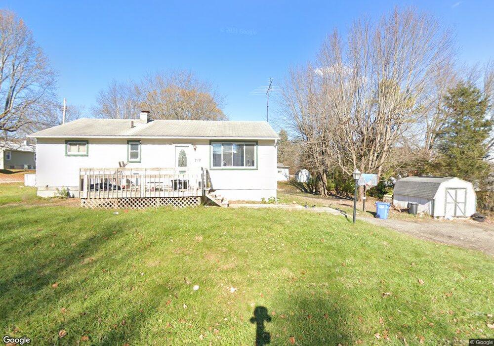
252 Maple Ct Mount Gilead, OH 43338
Estimated Value: $148,627 - $173,000
2
Beds
1
Bath
875
Sq Ft
$182/Sq Ft
Est. Value
About This Home
This home is located at 252 Maple Ct, Mount Gilead, OH 43338 and is currently estimated at $159,657, approximately $182 per square foot. 252 Maple Ct is a home located in Morrow County with nearby schools including Park Avenue Elementary School, Mt Gilead Middle School, and Mt Gilead High School.
Ownership History
Date
Name
Owned For
Owner Type
Purchase Details
Closed on
Dec 9, 2020
Sold by
Herrod John C
Bought by
Herrod Sharon K
Current Estimated Value
Purchase Details
Closed on
Oct 18, 2004
Sold by
Forrest Thomas Dwain and Kay Jennifer
Bought by
Herrod Sharon K and Herrod John C
Purchase Details
Closed on
Apr 13, 2004
Sold by
Forrest Jennifer Kay
Bought by
Forrest Thomas Dwain and Jennifer Kay
Purchase Details
Closed on
Aug 9, 2003
Sold by
Forrest Mary And
Bought by
Forrest Jennifer Kay
Purchase Details
Closed on
Mar 30, 1993
Bought by
Forrest Mary And
Create a Home Valuation Report for This Property
The Home Valuation Report is an in-depth analysis detailing your home's value as well as a comparison with similar homes in the area
Home Values in the Area
Average Home Value in this Area
Purchase History
| Date | Buyer | Sale Price | Title Company |
|---|---|---|---|
| Herrod Sharon K | -- | None Available | |
| Herrod Sharon K | $73,000 | -- | |
| Forrest Thomas Dwain | -- | -- | |
| Forrest Jennifer Kay | -- | -- | |
| Forrest Mary And | -- | -- |
Source: Public Records
Tax History
| Year | Tax Paid | Tax Assessment Tax Assessment Total Assessment is a certain percentage of the fair market value that is determined by local assessors to be the total taxable value of land and additions on the property. | Land | Improvement |
|---|---|---|---|---|
| 2025 | $1,076 | $37,030 | $6,300 | $30,730 |
| 2024 | $1,227 | $37,030 | $6,300 | $30,730 |
| 2023 | $1,227 | $37,030 | $6,300 | $30,730 |
| 2022 | $922 | $27,270 | $5,430 | $21,840 |
| 2021 | $879 | $27,270 | $5,430 | $21,840 |
| 2020 | $879 | $27,270 | $5,430 | $21,840 |
| 2019 | $729 | $23,740 | $4,730 | $19,010 |
| 2018 | $729 | $23,740 | $4,730 | $19,010 |
| 2017 | $680 | $23,250 | $4,730 | $18,520 |
| 2016 | $492 | $19,010 | $4,270 | $14,740 |
| 2015 | $460 | $19,010 | $4,270 | $14,740 |
| 2014 | $467 | $19,010 | $4,270 | $14,740 |
| 2013 | $527 | $21,110 | $4,730 | $16,380 |
Source: Public Records
Map
Nearby Homes
- 148 N Walnut St
- 4926 U S Highway 42
- 52 N Main St
- 211 W Union St
- 78 S Cherry St
- 85 S Cherry St
- 0 Tamarack Unit 223034150
- 202 Iberia St
- 0 Iberia St
- 250 S Main St
- 251 Lincoln Ave
- 473 N Delaware St
- 324 Lincoln Ave
- 614 Buckeye Ln
- 5720 County Road 30
- 669 Baker St
- 3664 Township Road 145
- 4350 Township Road 110
- 3341 Township Highway 145
- 106 William St
Your Personal Tour Guide
Ask me questions while you tour the home.