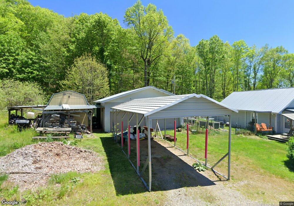
252 Ned Cove Rd Waynesville, NC 28785
Estimated Value: $316,163 - $422,000
2
Beds
1
Bath
780
Sq Ft
$465/Sq Ft
Est. Value
About This Home
This home is located at 252 Ned Cove Rd, Waynesville, NC 28785 and is currently estimated at $363,041, approximately $465 per square foot. 252 Ned Cove Rd is a home located in Haywood County with nearby schools including Jonathan Valley Elementary School, Waynesville Middle, and Tuscola High.
Ownership History
Date
Name
Owned For
Owner Type
Purchase Details
Closed on
Nov 3, 2014
Sold by
Evans Linda C and Evans Arthur H
Bought by
Robinson William Perry and Robinson Cheryl
Current Estimated Value
Home Financials for this Owner
Home Financials are based on the most recent Mortgage that was taken out on this home.
Original Mortgage
$130,000
Outstanding Balance
$43,076
Interest Rate
3.45%
Mortgage Type
Seller Take Back
Estimated Equity
$319,965
Purchase Details
Closed on
Feb 5, 2004
Bought by
Evans Linda C
Create a Home Valuation Report for This Property
The Home Valuation Report is an in-depth analysis detailing your home's value as well as a comparison with similar homes in the area
Home Values in the Area
Average Home Value in this Area
Purchase History
| Date | Buyer | Sale Price | Title Company |
|---|---|---|---|
| Robinson William Perry | $143,000 | None Available | |
| Evans Linda C | -- | -- |
Source: Public Records
Mortgage History
| Date | Status | Borrower | Loan Amount |
|---|---|---|---|
| Open | Robinson William Perry | $130,000 |
Source: Public Records
Tax History Compared to Growth
Tax History
| Year | Tax Paid | Tax Assessment Tax Assessment Total Assessment is a certain percentage of the fair market value that is determined by local assessors to be the total taxable value of land and additions on the property. | Land | Improvement |
|---|---|---|---|---|
| 2025 | -- | $174,900 | $39,100 | $135,800 |
| 2024 | $1,205 | $168,700 | $39,100 | $129,600 |
| 2023 | $1,205 | $168,700 | $39,100 | $129,600 |
| 2022 | $1,180 | $168,700 | $39,100 | $129,600 |
| 2021 | $1,180 | $168,700 | $39,100 | $129,600 |
| 2020 | $1,059 | $137,400 | $39,100 | $98,300 |
| 2019 | $1,064 | $137,400 | $39,100 | $98,300 |
| 2018 | $979 | $124,400 | $39,100 | $85,300 |
| 2017 | $979 | $124,400 | $0 | $0 |
| 2016 | $897 | $115,300 | $0 | $0 |
| 2015 | $897 | $115,300 | $0 | $0 |
| 2014 | $797 | $115,300 | $0 | $0 |
Source: Public Records
Map
Nearby Homes
- 000 Roaring Creek Ln
- 4 Roaring Creek Ln
- 114 Clear Creek Ln
- 110 Clear Creek Ln
- 269 Oakstone Dr
- 85 Garnet Spring Ln
- Lot 17 Covered Bridge Trail Unit 17
- Lot 24 Covered Bridge Trail Unit 24
- 99999 Molasses Way Unit 18
- 150 Sorghum Dr
- 9999 Divit Rd Unit 45
- 31 Windsong Dr
- 8 Lots Frontier Way
- 11 Prosperity Ridge
- 0 Cradling Cove Unit 3
- 000 Songbird Trail
- 0 Asa Trail
- Lot 23 Asa Trail
- 00 Ellenberger Dr Unit 401
- 64 Cradling Cove
- 164 Jumping Branch Trail
- 38 Dewberry Ln
- 165 Maelarkin Trail
- 35 Ned Cove Rd
- 209 Maelarkin Trail
- 371 Ned Cove Rd
- 2050 Hemphill Rd
- 447 Ned Cove Rd
- 85 Mountainside Dr
- TBD Hemphill Rd
- 24 Maelarkin Trail
- 2293 Hemphill Rd
- 2179 Hemphill Rd
- 38 Roaring Creek Ln
- 38 Roaring Creek Ln Unit 1 & 2
- 17 Babbling Brook Ln
- 2289 Hemphill Rd
- 30 Mountain Mist Ln
- 2195 Hemphill Rd
- 88 Roaring Creek Ln