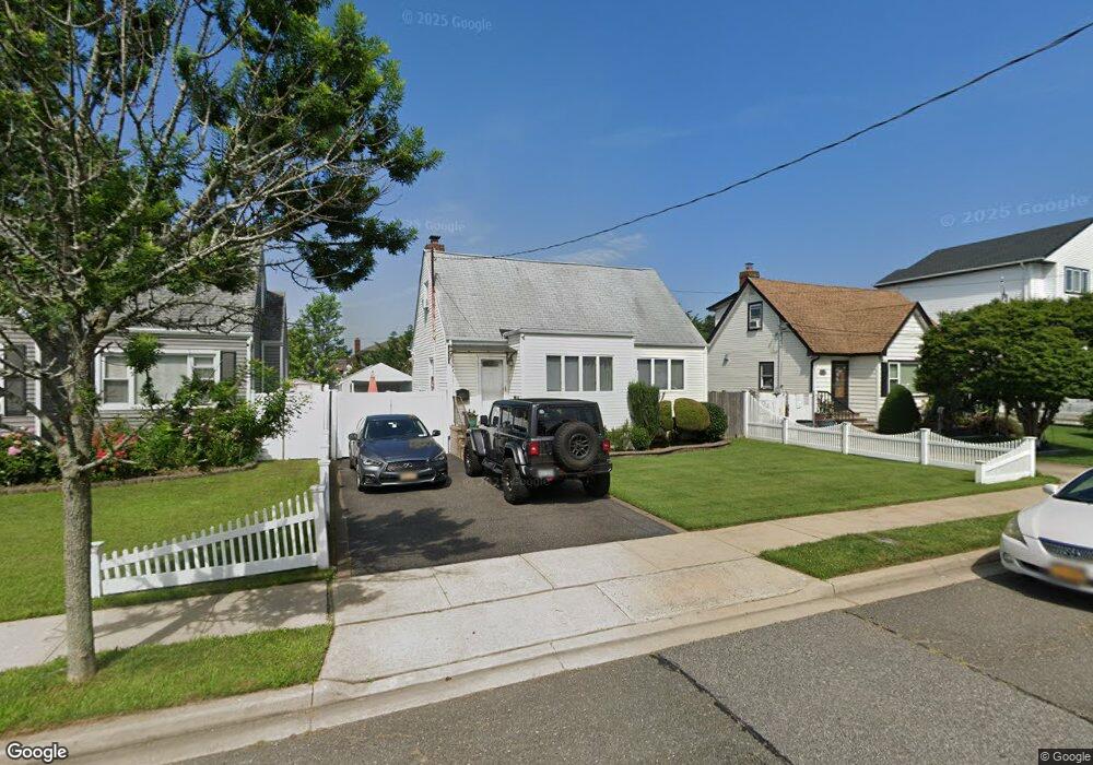
252 Roosevelt Ave Freeport, NY 11520
Estimated Value: $594,752 - $609,000
3
Beds
1
Bath
1,131
Sq Ft
$532/Sq Ft
Est. Value
About This Home
This home is located at 252 Roosevelt Ave, Freeport, NY 11520 and is currently estimated at $601,876, approximately $532 per square foot. 252 Roosevelt Ave is a home located in Nassau County with nearby schools including Columbus Avenue School, Caroline G. Atkinson Intermediate School, and John W Dodd Middle School.
Ownership History
Date
Name
Owned For
Owner Type
Purchase Details
Closed on
Apr 17, 2015
Sold by
Miller Myra L
Bought by
Francois Myra
Current Estimated Value
Purchase Details
Closed on
Dec 5, 2005
Sold by
Property Development Netw
Bought by
Miller Myra
Purchase Details
Closed on
Feb 10, 2005
Sold by
Cincotta Anthony J
Purchase Details
Closed on
Jul 30, 1999
Sold by
Zottoli Anthony and Zottoli Maria
Bought by
Ferreris Raymond
Home Financials for this Owner
Home Financials are based on the most recent Mortgage that was taken out on this home.
Original Mortgage
$155,800
Interest Rate
7.53%
Create a Home Valuation Report for This Property
The Home Valuation Report is an in-depth analysis detailing your home's value as well as a comparison with similar homes in the area
Home Values in the Area
Average Home Value in this Area
Purchase History
| Date | Buyer | Sale Price | Title Company |
|---|---|---|---|
| Francois Myra | -- | Stewart Title | |
| Miller Myra | $360,000 | -- | |
| -- | $245,200 | -- | |
| Ferreris Raymond | $164,000 | First American Title Ins Co |
Source: Public Records
Mortgage History
| Date | Status | Borrower | Loan Amount |
|---|---|---|---|
| Previous Owner | Ferreris Raymond | $155,800 |
Source: Public Records
Tax History Compared to Growth
Tax History
| Year | Tax Paid | Tax Assessment Tax Assessment Total Assessment is a certain percentage of the fair market value that is determined by local assessors to be the total taxable value of land and additions on the property. | Land | Improvement |
|---|---|---|---|---|
| 2025 | $6,469 | $300 | $144 | $156 |
| 2024 | $636 | $295 | $142 | $153 |
| 2023 | $6,094 | $300 | $144 | $156 |
| 2022 | $4,628 | $300 | $144 | $156 |
| 2021 | $5,212 | $316 | $151 | $165 |
| 2020 | $5,212 | $401 | $400 | $1 |
| 2019 | $4,563 | $401 | $400 | $1 |
| 2018 | $4,370 | $401 | $0 | $0 |
| 2017 | $3,727 | $426 | $340 | $86 |
| 2016 | $4,366 | $562 | $448 | $114 |
| 2015 | $812 | $562 | $448 | $114 |
| 2014 | $812 | $562 | $448 | $114 |
| 2013 | $767 | $562 | $448 | $114 |
Source: Public Records
Map
Nearby Homes
- 119 S Bay Ave
- 173 Cedar St
- 31 Casino St Unit PH
- 310 Miller Ave
- 437 Ray St
- 171 Westside Ave
- 322 Miller Ave
- 494 S Ocean Ave Unit 1H
- 494 S Ocean Ave Unit 3A
- 16 Johnson Place
- 209 Nassau Ave
- 159 Branch Ave
- 374 Miller Ave
- 451 Atlantic Ave
- 232 Nassau Ave
- 153 Westend Ave
- 120 Sportsmans Ave
- 226 Westside Ave Unit B
- 570 S Ocean Ave
- 208 Sportsmans Ave
- 248 Roosevelt Ave
- 248 Roosevelt Ave
- 256 Roosevelt Ave
- 256 Roosevelt Ave
- 244 Roosevelt Ave
- 244 Roosevelt Ave
- 260 Roosevelt Ave
- 260 Roosevelt Ave
- 105 S Bay Ave
- 105 S Bay Ave
- 264 Roosevelt Ave
- 240 Roosevelt Ave
- 240 Roosevelt Ave
- 251 Roosevelt Ave
- 249 Roosevelt Ave
- 99 S Bay Ave
- 99 S Bay Ave
- 255 Roosevelt Ave
- 243 Roosevelt Ave
- 237 Roosevelt Ave