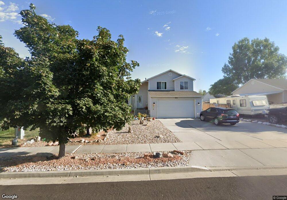
252 W 670 N Tooele, UT 84074
Estimated Value: $391,338 - $401,000
3
Beds
3
Baths
1,750
Sq Ft
$226/Sq Ft
Est. Value
About This Home
This home is located at 252 W 670 N, Tooele, UT 84074 and is currently estimated at $395,835, approximately $226 per square foot. 252 W 670 N is a home located in Tooele County with nearby schools including Northlake Elementary School, Tooele Junior High School, and Tooele High School.
Ownership History
Date
Name
Owned For
Owner Type
Purchase Details
Closed on
Sep 19, 2019
Sold by
Thielen David and Thielen Diane
Bought by
Thielen David and Thielen Diane
Current Estimated Value
Home Financials for this Owner
Home Financials are based on the most recent Mortgage that was taken out on this home.
Original Mortgage
$108,600
Interest Rate
3.5%
Mortgage Type
New Conventional
Purchase Details
Closed on
Mar 13, 2015
Sold by
Castagno Diane and Thielen Diane
Bought by
The David Thelen And Diane Thielen Livin and Thielen Diane
Create a Home Valuation Report for This Property
The Home Valuation Report is an in-depth analysis detailing your home's value as well as a comparison with similar homes in the area
Home Values in the Area
Average Home Value in this Area
Purchase History
| Date | Buyer | Sale Price | Title Company |
|---|---|---|---|
| Thielen David | -- | Timios Agency Of Utah Inc | |
| The David Thelen And Diane Thielen Livin | -- | None Available |
Source: Public Records
Mortgage History
| Date | Status | Borrower | Loan Amount |
|---|---|---|---|
| Closed | Thielen David | $108,600 |
Source: Public Records
Tax History Compared to Growth
Tax History
| Year | Tax Paid | Tax Assessment Tax Assessment Total Assessment is a certain percentage of the fair market value that is determined by local assessors to be the total taxable value of land and additions on the property. | Land | Improvement |
|---|---|---|---|---|
| 2025 | $2,632 | $399,203 | $97,500 | $301,703 |
| 2024 | $2,793 | $213,194 | $53,625 | $159,569 |
| 2023 | $2,793 | $207,013 | $51,076 | $155,937 |
| 2022 | $2,532 | $217,809 | $65,065 | $152,744 |
| 2021 | $2,066 | $148,648 | $20,144 | $128,504 |
| 2020 | $1,965 | $245,235 | $36,625 | $208,610 |
| 2019 | $1,843 | $226,270 | $36,625 | $189,645 |
| 2018 | $1,660 | $193,216 | $32,500 | $160,716 |
| 2017 | $1,399 | $193,216 | $32,500 | $160,716 |
| 2016 | $890 | $72,294 | $19,250 | $53,044 |
| 2015 | $890 | $64,751 | $0 | $0 |
| 2014 | -- | $64,751 | $0 | $0 |
Source: Public Records
Map
Nearby Homes
- 228 W 670 N
- 277 W 670 N
- 374 W 630 North St Unit 10
- 742 N 170 W
- 352 W 600 N Unit 44
- Snowbird Plan at Vista Meadows
- Sundance Plan at Vista Meadows
- Brighton Plan at Vista Meadows
- Solitude Plan at Vista Meadows
- 372 W 600 N Unit 42
- 312 W Sapphire Dr
- 182 Alfred Dr
- 409 W Sapphire Dr Unit 7040
- 834 N 200 W
- 429 W Sapphire Dr Unit 7038
- 412 W Sapphire Dr Unit 7009
- 107 W 600 N Unit 204
- 610 N 100 W
- 459 W Sapphire Dr Unit 7034
- 294 W Quartz Rd