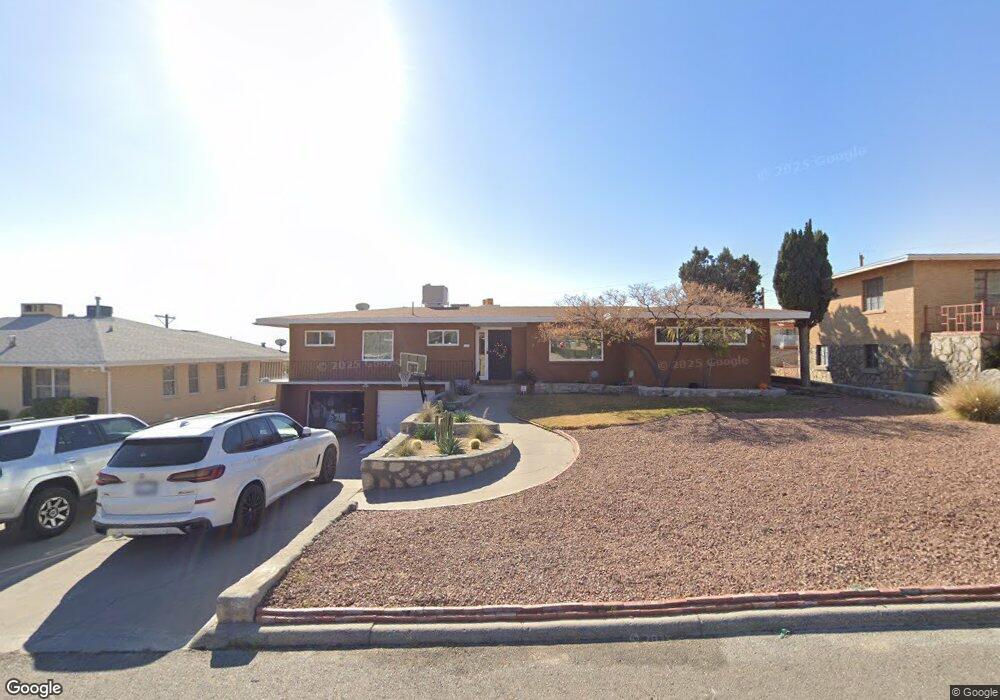
2520 Memphis Ave El Paso, TX 79930
Grandview NeighborhoodEstimated Value: $329,417 - $395,000
4
Beds
3
Baths
2,742
Sq Ft
$130/Sq Ft
Est. Value
About This Home
This home is located at 2520 Memphis Ave, El Paso, TX 79930 and is currently estimated at $357,104, approximately $130 per square foot. 2520 Memphis Ave is a home located in El Paso County with nearby schools including Crockett Elementary School, Armendariz Middle School, and Middle School-5 NW Middle.
Ownership History
Date
Name
Owned For
Owner Type
Purchase Details
Closed on
Nov 14, 2007
Sold by
Worth Ingrid W and Warach Robert
Bought by
Merritt Braxton and Merritt William
Current Estimated Value
Home Financials for this Owner
Home Financials are based on the most recent Mortgage that was taken out on this home.
Original Mortgage
$81,000
Outstanding Balance
$51,355
Interest Rate
6.42%
Mortgage Type
Purchase Money Mortgage
Estimated Equity
$305,749
Purchase Details
Closed on
Dec 29, 1995
Sold by
Dennehy Maureen and Haggin Maureen Dennehy
Bought by
Worth Michael A and Worth Ingrid W
Home Financials for this Owner
Home Financials are based on the most recent Mortgage that was taken out on this home.
Original Mortgage
$100,000
Interest Rate
7.34%
Mortgage Type
Seller Take Back
Create a Home Valuation Report for This Property
The Home Valuation Report is an in-depth analysis detailing your home's value as well as a comparison with similar homes in the area
Home Values in the Area
Average Home Value in this Area
Purchase History
| Date | Buyer | Sale Price | Title Company |
|---|---|---|---|
| Merritt Braxton | -- | None Available | |
| Worth Michael A | -- | -- |
Source: Public Records
Mortgage History
| Date | Status | Borrower | Loan Amount |
|---|---|---|---|
| Open | Merritt Braxton | $81,000 | |
| Previous Owner | Worth Michael A | $100,000 |
Source: Public Records
Tax History Compared to Growth
Tax History
| Year | Tax Paid | Tax Assessment Tax Assessment Total Assessment is a certain percentage of the fair market value that is determined by local assessors to be the total taxable value of land and additions on the property. | Land | Improvement |
|---|---|---|---|---|
| 2025 | $4,671 | $246,245 | -- | -- |
| 2024 | $4,671 | $223,859 | -- | -- |
| 2023 | $4,671 | $203,508 | $0 | $0 |
| 2022 | $5,476 | $185,007 | $0 | $0 |
| 2021 | $5,251 | $168,188 | $25,389 | $142,799 |
| 2020 | $5,458 | $177,567 | $20,311 | $157,256 |
| 2018 | $4,984 | $168,394 | $20,311 | $148,083 |
| 2017 | $4,832 | $171,542 | $20,311 | $151,231 |
| 2016 | $5,152 | $182,925 | $20,311 | $162,614 |
| 2015 | $4,948 | $182,925 | $20,311 | $162,614 |
| 2014 | $4,948 | $189,719 | $20,311 | $169,408 |
Source: Public Records
Map
Nearby Homes
- 2610 Frankfort Ave
- PN-391630 Alabama St
- 2300 Red Sky Ln
- 2903 Savannah Ave
- 2406 Lebanon Ave
- 2816 N Piedras St
- 2917 Mobile Ave
- 2624 Aurora Ave
- 2735 Aurora Ave
- 3009 Savannah Ave
- 1813 & 181 Alabama St
- PN-258825 Tbd
- 2630 Wheeling Ave
- 3018 Sacramento Ave
- 2510 Federal Ave
- 2413 Copper Ave
- 3204 Memphis Ave
- 1712 Elm St
- 1701 Elm St
- 1605 Dakota St
- 2516 Memphis Ave
- 2522 Memphis Ave
- 2519 Frankfort Ave
- 2525 Frankfort Ave
- 2508 Memphis Ave
- 2524 Memphis Ave
- 2515 Frankfort Ave
- 2517 Memphis Ave
- 2521 Memphis Ave
- 2531 Frankfort Ave
- 2515 Memphis Ave
- 2601 Alabama St
- 2504 Memphis Ave
- 2507 Frankfort Ave
- 2507 Memphis Ave
- 2530 Alabama St
- 2500 Memphis Ave
- 2601 Frankfort Ave
- 2520 Frankfort Ave
- 2526 Frankfort Ave