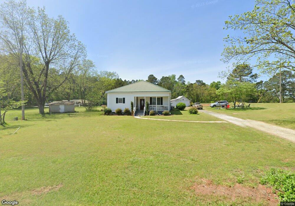
2523 Highway 41 S Forsyth, GA 31029
Smarr NeighborhoodEstimated Value: $255,315 - $366,000
3
Beds
2
Baths
2,056
Sq Ft
$152/Sq Ft
Est. Value
About This Home
This home is located at 2523 Highway 41 S, Forsyth, GA 31029 and is currently estimated at $312,105, approximately $151 per square foot. 2523 Highway 41 S is a home located in Monroe County with nearby schools including T.G. Scott Elementary School, Mary Persons High School, and Monroe Academy.
Ownership History
Date
Name
Owned For
Owner Type
Purchase Details
Closed on
May 27, 1997
Bought by
Williamson Mary T and Williamson Dennis
Current Estimated Value
Create a Home Valuation Report for This Property
The Home Valuation Report is an in-depth analysis detailing your home's value as well as a comparison with similar homes in the area
Home Values in the Area
Average Home Value in this Area
Purchase History
| Date | Buyer | Sale Price | Title Company |
|---|---|---|---|
| Williamson Mary T | -- | -- |
Source: Public Records
Tax History Compared to Growth
Tax History
| Year | Tax Paid | Tax Assessment Tax Assessment Total Assessment is a certain percentage of the fair market value that is determined by local assessors to be the total taxable value of land and additions on the property. | Land | Improvement |
|---|---|---|---|---|
| 2024 | $1,149 | $52,800 | $12,800 | $40,000 |
| 2023 | $1,102 | $46,360 | $12,800 | $33,560 |
| 2022 | $930 | $46,360 | $12,800 | $33,560 |
| 2021 | $963 | $46,360 | $12,800 | $33,560 |
| 2020 | $987 | $46,360 | $12,800 | $33,560 |
| 2019 | $936 | $46,360 | $12,800 | $33,560 |
| 2018 | $939 | $44,320 | $12,800 | $31,520 |
| 2017 | $1,288 | $44,320 | $12,800 | $31,520 |
| 2016 | $893 | $44,320 | $12,800 | $31,520 |
| 2015 | $847 | $44,320 | $12,800 | $31,520 |
| 2014 | $818 | $44,320 | $12,800 | $31,520 |
Source: Public Records
Map
Nearby Homes
- 0 Old Rumble Rd
- TRACTS 1 & 5 Old Rumble Rd
- TRACTS 2-4 Old Rumble Rd
- 1550 Charlie Benson Rd
- 22 Rabon Dr
- 122 Laurel Ridge
- 34 Kyndall Ln
- 98 Adam Dr
- 88 Adam Dr
- 14 Oak Valley Dr
- Lot 27-A-1 Creekside Trail
- Lot 26-A-1 Creekside Trail
- Lot 26-A-2 Creekside Trail
- Lot 15-A-1 Creekside Ln
- 350 Lee King Rd
- Lot 15-A-2 Creekside Ln
- 131 Hawthorne Ln
- 125 Hawthorne Ln
- 0 Rocky Creek Ct Unit 10 8281794
- 0 Reedy Creek Rd Unit 2599290
- 0 Reedy Creek Rd Unit LOT A 3220865
- 0 Reedy Creek Rd Unit 3251362
- 0 Rocky Creek Ct Unit 7383850
- 0 Rocky Creek Ct Unit 7282976
- 0 Reedy Creek Rd Unit 7393294
- 0 Reedy Creek Rd Unit 7534036
- 0 Reedy Creek Rd Unit LOT 81 7556812
- 0 Rocky Creek Ct Unit 10A 7616900
- 0 Reedy Creek Rd Unit 8088681
- 0 Rocky Creek Ct Unit 10
- 0 Reedy Creek Rd Unit 143706
- 0 Rocky Creek Ct Unit 126297
- 0 Rocky Creek Ct Unit 7374398
- 0 Reedy Creek Rd Unit 7182273
- 0 Rocky Creek Ct Unit 7064705
- 0 Rocky Creek Ct Unit 3138947
- 0 Rocky Creek Ct Unit A 2882419
- 0 Rocky Creek Ct Unit 11, 12, & 13 8084199