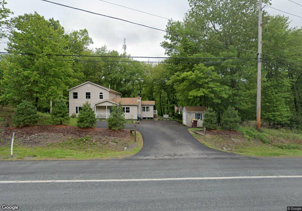
2525 Milford Rd Bushkill, PA 18324
Estimated Value: $277,689 - $329,000
3
Beds
2
Baths
2,208
Sq Ft
$137/Sq Ft
Est. Value
About This Home
This home is located at 2525 Milford Rd, Bushkill, PA 18324 and is currently estimated at $303,345, approximately $137 per square foot. 2525 Milford Rd is a home with nearby schools including Bushkill Elementary and Lehman Intermediate School.
Ownership History
Date
Name
Owned For
Owner Type
Purchase Details
Closed on
Feb 4, 2021
Sold by
Pinter Elizabeth R and Treible Elizabeth R
Bought by
Treible Ross A and Treible Elizabeth R
Current Estimated Value
Home Financials for this Owner
Home Financials are based on the most recent Mortgage that was taken out on this home.
Original Mortgage
$140,600
Outstanding Balance
$103,289
Interest Rate
2.6%
Mortgage Type
New Conventional
Estimated Equity
$200,056
Purchase Details
Closed on
Jul 12, 2006
Sold by
Mckeever Mark
Bought by
Commonwealth Of Pennyslvania
Create a Home Valuation Report for This Property
The Home Valuation Report is an in-depth analysis detailing your home's value as well as a comparison with similar homes in the area
Home Values in the Area
Average Home Value in this Area
Purchase History
| Date | Buyer | Sale Price | Title Company |
|---|---|---|---|
| Treible Ross A | -- | None Available | |
| Commonwealth Of Pennyslvania | -- | None Available |
Source: Public Records
Mortgage History
| Date | Status | Borrower | Loan Amount |
|---|---|---|---|
| Open | Treible Ross A | $140,600 |
Source: Public Records
Tax History Compared to Growth
Tax History
| Year | Tax Paid | Tax Assessment Tax Assessment Total Assessment is a certain percentage of the fair market value that is determined by local assessors to be the total taxable value of land and additions on the property. | Land | Improvement |
|---|---|---|---|---|
| 2025 | $4,794 | $29,680 | $3,900 | $25,780 |
| 2024 | $4,794 | $29,680 | $3,900 | $25,780 |
| 2023 | $4,721 | $29,680 | $3,900 | $25,780 |
| 2022 | $4,575 | $29,680 | $3,900 | $25,780 |
| 2021 | $4,533 | $29,680 | $3,900 | $25,780 |
| 2020 | $4,533 | $29,680 | $3,900 | $25,780 |
| 2019 | $4,474 | $29,680 | $3,900 | $25,780 |
| 2018 | $4,451 | $29,680 | $3,900 | $25,780 |
| 2017 | $4,367 | $29,680 | $3,900 | $25,780 |
| 2016 | $0 | $29,680 | $3,900 | $25,780 |
| 2015 | -- | $29,680 | $3,900 | $25,780 |
| 2014 | -- | $29,680 | $3,900 | $25,780 |
Source: Public Records
Map
Nearby Homes
- 613 George Place
- 116 Quail Ct
- Lot 13 Sutter Dr
- LOT 17 Pocono Blvd
- 283 Pocono Blvd
- 4932 Pine Ridge Dr W
- 140 Davis Cir
- 139 Davis Cir
- 459 Pocono Blvd
- 2312 Cramer Ct
- 4165 Pine Ridge Dr
- 679 Raccoon Ct
- 0 Raccoon Ct
- Lot 679 Raccoon Ct
- 679L Raccoon Ct
- 153 Segatti Cir
- 4774 Pine Ridge Dr W
- 0 Segatti Cir Unit LOT 218 735536
- 129 Segatti Cir
- 1127 Steele Cir
- 13 Pheasant Run
- 106 Pheasant Run
- 2513 Milford Rd
- 111 Pheasant Run
- 1006 Wild Turkey Ln
- 2059 Milford Rd
- 43 Pheasant Run
- 8 Pheasant Run
- 1011 Wild Turkey Ln
- 141 Pheasant Run
- 518 Stewart Ct
- 155 Pheasant Run
- 1 Pheasant Run
- 90 Pheasant Run
- 91 Pheasant Run
- 1029 Pheasant Run
- 511 Stewart Ct
- 112 Pheasant Run
- 161 Pheasant Run
- 58 Pheasant Run