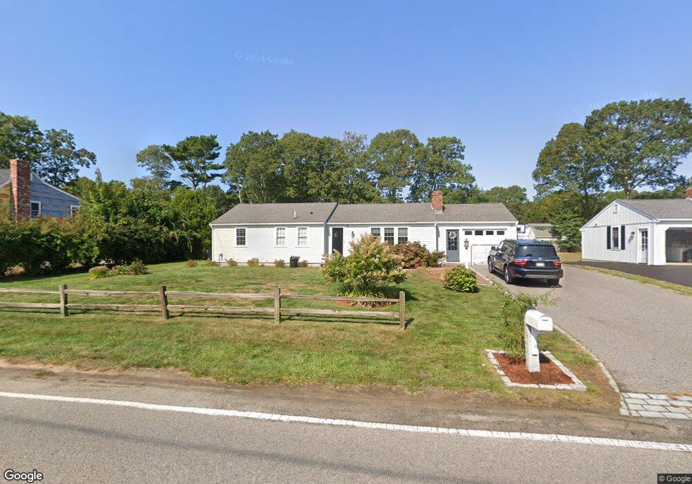
253 Nottingham Dr Centerville, MA 02632
Centerville NeighborhoodEstimated Value: $583,000 - $639,000
3
Beds
2
Baths
1,488
Sq Ft
$411/Sq Ft
Est. Value
About This Home
This home is located at 253 Nottingham Dr, Centerville, MA 02632 and is currently estimated at $611,076, approximately $410 per square foot. 253 Nottingham Dr is a home located in Barnstable County with nearby schools including West Villages Elementary School, Barnstable United Elementary School, and Barnstable Intermediate School.
Ownership History
Date
Name
Owned For
Owner Type
Purchase Details
Closed on
Sep 8, 2005
Sold by
Aalto James S and Aalto Susan A
Bought by
Mcnally James
Current Estimated Value
Home Financials for this Owner
Home Financials are based on the most recent Mortgage that was taken out on this home.
Original Mortgage
$273,600
Outstanding Balance
$145,824
Interest Rate
5.79%
Mortgage Type
Purchase Money Mortgage
Estimated Equity
$465,252
Purchase Details
Closed on
Jun 12, 1998
Sold by
Sullivan Frederick J and Sullivan Joanne M
Bought by
Aalto James S
Home Financials for this Owner
Home Financials are based on the most recent Mortgage that was taken out on this home.
Original Mortgage
$70,000
Interest Rate
7.11%
Mortgage Type
Purchase Money Mortgage
Create a Home Valuation Report for This Property
The Home Valuation Report is an in-depth analysis detailing your home's value as well as a comparison with similar homes in the area
Home Values in the Area
Average Home Value in this Area
Purchase History
| Date | Buyer | Sale Price | Title Company |
|---|---|---|---|
| Mcnally James | $342,000 | -- | |
| Aalto James S | $90,000 | -- |
Source: Public Records
Mortgage History
| Date | Status | Borrower | Loan Amount |
|---|---|---|---|
| Open | Mcnally James | $273,600 | |
| Closed | Mcnally James | $34,200 | |
| Previous Owner | Aalto James S | $70,000 |
Source: Public Records
Tax History
| Year | Tax Paid | Tax Assessment Tax Assessment Total Assessment is a certain percentage of the fair market value that is determined by local assessors to be the total taxable value of land and additions on the property. | Land | Improvement |
|---|---|---|---|---|
| 2025 | $4,545 | $561,800 | $151,900 | $409,900 |
| 2024 | $4,420 | $566,000 | $151,900 | $414,100 |
| 2023 | $4,191 | $502,500 | $138,100 | $364,400 |
| 2022 | $3,449 | $357,800 | $102,300 | $255,500 |
| 2021 | $2,092 | $314,500 | $102,300 | $212,200 |
| 2020 | $2,040 | $306,200 | $102,300 | $203,900 |
| 2019 | $1,991 | $284,700 | $102,300 | $182,400 |
| 2018 | $2,910 | $259,400 | $107,700 | $151,700 |
| 2017 | $1,804 | $253,400 | $107,700 | $145,700 |
| 2016 | $2,771 | $254,200 | $108,500 | $145,700 |
| 2015 | $2,662 | $245,300 | $105,100 | $140,200 |
Source: Public Records
Map
Nearby Homes
- 315 Prince Hinckley Rd
- 87 Foxglove Rd
- 1028 Old Falmouth Rd
- 900 Old Stage Rd
- 296 Buckskin Path
- 62 Three Ponds Dr
- 7 Ebenezer
- 324 Patriot Way
- 80 Branch Terrace
- 74 Saddler Ln
- 51 Larch Ln
- 66 Tern Ln
- 82 Yacht Club Rd
- 200 Lumbert Mill Rd
- 19 Marrick Ct
- 53 Meadow Farm Rd
- 52 Meadow Farm Rd
- 103 Pine Tree Dr
- 32 Willington Ave
- 192 Sandy Valley Rd
- 263 Nottingham Dr
- 243 Nottingham Dr
- 156 Sheaffer Rd
- 166 Sheaffer Rd
- 146 Sheaffer Rd
- 248 Nottingham Dr
- 273 Nottingham Dr
- 233 Nottingham Dr
- 260 Nottingham Dr
- 236 Nottingham Dr
- 176 Sheaffer Rd
- 136 Sheaffer Rd
- 223 Nottingham Dr
- 283 Nottingham Dr
- 274 Nottingham Dr
- 155 Ansel Howland Rd
- 167 Ansel Howland Rd
- 126 Sheaffer Rd
- 186 Sheaffer Rd
- 222 Nottingham Dr
Your Personal Tour Guide
Ask me questions while you tour the home.