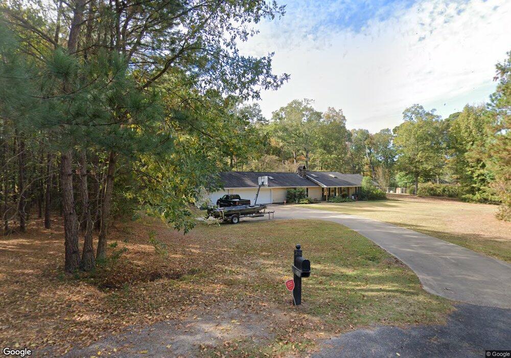
253 Peach Tree Rd West Monroe, LA 71291
Estimated Value: $312,000 - $367,000
3
Beds
3
Baths
3,926
Sq Ft
$87/Sq Ft
Est. Value
About This Home
This home is located at 253 Peach Tree Rd, West Monroe, LA 71291 and is currently estimated at $342,564, approximately $87 per square foot. 253 Peach Tree Rd is a home located in Ouachita Parish with nearby schools including Drew Elementary School and West Monroe High School.
Ownership History
Date
Name
Owned For
Owner Type
Purchase Details
Closed on
Mar 11, 2009
Sold by
Busby David W and Busby Nancy Jespen
Bought by
Sherwin Todd Philip and Sherwin Rebecca Elizabeth Duston
Current Estimated Value
Home Financials for this Owner
Home Financials are based on the most recent Mortgage that was taken out on this home.
Original Mortgage
$201,286
Interest Rate
4.85%
Mortgage Type
Purchase Money Mortgage
Create a Home Valuation Report for This Property
The Home Valuation Report is an in-depth analysis detailing your home's value as well as a comparison with similar homes in the area
Home Values in the Area
Average Home Value in this Area
Purchase History
| Date | Buyer | Sale Price | Title Company |
|---|---|---|---|
| Sherwin Todd Philip | $205,000 | None Available |
Source: Public Records
Mortgage History
| Date | Status | Borrower | Loan Amount |
|---|---|---|---|
| Closed | Sherwin Todd Philip | $201,286 |
Source: Public Records
Tax History Compared to Growth
Tax History
| Year | Tax Paid | Tax Assessment Tax Assessment Total Assessment is a certain percentage of the fair market value that is determined by local assessors to be the total taxable value of land and additions on the property. | Land | Improvement |
|---|---|---|---|---|
| 2024 | $1,997 | $29,249 | $4,342 | $24,907 |
| 2023 | $1,997 | $26,640 | $4,342 | $22,298 |
| 2022 | $2,363 | $26,640 | $4,342 | $22,298 |
| 2021 | $2,393 | $26,640 | $4,342 | $22,298 |
| 2020 | $2,393 | $26,640 | $4,342 | $22,298 |
| 2019 | $2,225 | $24,842 | $3,493 | $21,349 |
| 2018 | $1,553 | $24,842 | $3,493 | $21,349 |
| 2017 | $2,225 | $24,842 | $3,493 | $21,349 |
| 2016 | $2,224 | $20,079 | $3,000 | $17,079 |
| 2015 | $1,124 | $20,079 | $3,000 | $17,079 |
| 2014 | $1,124 | $20,079 | $3,000 | $17,079 |
| 2013 | $1,120 | $20,079 | $3,000 | $17,079 |
Source: Public Records
Map
Nearby Homes
- 110 Fox Run Unit 110 Fox run
- 107 Sioux Dr
- 100 Aspen Cir
- 127 Henry Rd
- 865 Johnson Rd
- 149 Comanche Trail
- 0 Bonnabel Place
- 107 Bonnabel Place
- 830 Ole Highway 15
- 150 Ingram Rd
- 1119 Comanche Trail
- 108 Comanche Trail
- 109 A Canyon Rd
- 163 Lost Landing Rd
- 000 Strozier Rd
- 3242 Arkansas Rd
- 158 Rex Robertson Rd
- 0 Canyon Rd
- 171 Chimney Hill Rd
- 106 Brooks Ln
- 115 Sandhurst Cir
- 116 Sandhurst Cir
- 250 Peach Tree Rd
- 247 Peach Tree Rd
- 114 Sandhurst Cir
- 114 Brandon Cir
- 113 Brandon Cir
- 113 Sandhurst Cir
- 112 Sandhurst Cir
- 0 Brandon Cir
- 112 Brandon Cir
- 111 Brandon Cir
- 109 Sandhurst Cir
- 110 Brandon Cir
- 110 Sandhurst Cir
- 240 Peach Tree Rd
- 108 Sandhurst Cir
- 241 Peach Tree Rd
- 405 Lakewood Loop Dr
- 108 Brandon Cir