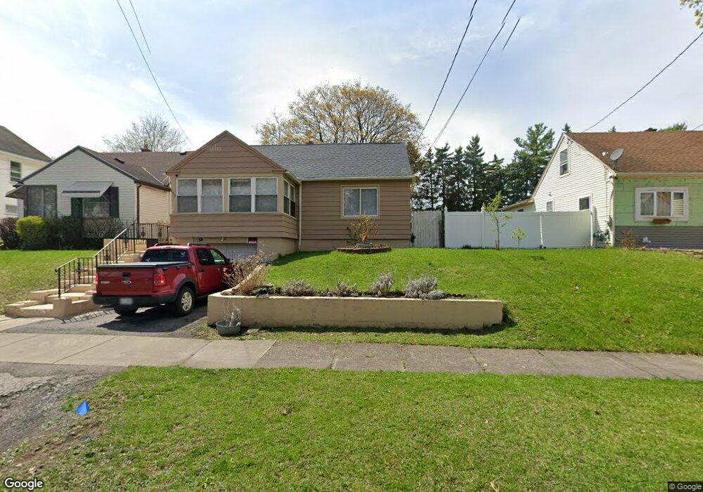
253 Townsend St Rochester, NY 14621
Northeast Rochester NeighborhoodEstimated Value: $83,000 - $153,000
2
Beds
1
Bath
762
Sq Ft
$148/Sq Ft
Est. Value
About This Home
This home is located at 253 Townsend St, Rochester, NY 14621 and is currently estimated at $112,516, approximately $147 per square foot. 253 Townsend St is a home located in Monroe County with nearby schools including School 39-Andrew J. Townson, School 9-DR Martin Luther King Jr, and Mary McLeod Bethune School No. 45.
Ownership History
Date
Name
Owned For
Owner Type
Purchase Details
Closed on
Jul 7, 2014
Sold by
Aloi Edward R
Bought by
Aloi Peter
Current Estimated Value
Purchase Details
Closed on
Nov 2, 2001
Sold by
City Rochester
Bought by
Aloi Edward R
Purchase Details
Closed on
Oct 12, 2001
Sold by
Hud
Bought by
City Of Rochester
Purchase Details
Closed on
Mar 19, 2001
Sold by
Kellogg Scott D
Bought by
Hud
Purchase Details
Closed on
Mar 17, 1997
Bought by
St 253 Townsend
Create a Home Valuation Report for This Property
The Home Valuation Report is an in-depth analysis detailing your home's value as well as a comparison with similar homes in the area
Home Values in the Area
Average Home Value in this Area
Purchase History
| Date | Buyer | Sale Price | Title Company |
|---|---|---|---|
| Aloi Peter | $30,000 | None Available | |
| Aloi Edward R | $19,900 | Daniel Bryson | |
| City Of Rochester | $8,500 | -- | |
| Hud | -- | -- | |
| St 253 Townsend | $49,000 | -- |
Source: Public Records
Tax History Compared to Growth
Tax History
| Year | Tax Paid | Tax Assessment Tax Assessment Total Assessment is a certain percentage of the fair market value that is determined by local assessors to be the total taxable value of land and additions on the property. | Land | Improvement |
|---|---|---|---|---|
| 2024 | $504 | $82,600 | $10,100 | $72,500 |
| 2023 | $799 | $62,000 | $4,000 | $58,000 |
| 2022 | $745 | $62,000 | $4,000 | $58,000 |
| 2021 | $756 | $62,000 | $4,000 | $58,000 |
| 2020 | $711 | $62,000 | $4,000 | $58,000 |
| 2019 | $681 | $53,000 | $4,000 | $49,000 |
| 2018 | $0 | $53,000 | $4,000 | $49,000 |
| 2017 | $0 | $53,000 | $4,000 | $49,000 |
| 2016 | $681 | $53,000 | $4,000 | $49,000 |
| 2015 | $1,255 | $53,000 | $4,000 | $49,000 |
| 2014 | $1,255 | $53,000 | $4,000 | $49,000 |
Source: Public Records
Map
Nearby Homes
- 232 Townsend St
- 39 Townsend St
- 32 van Stallen St
- 75 van Stallen St
- 111 van Stallen St Unit 113
- 137 van Stallen St
- 1358 Hudson Ave
- 190 Weaver St
- 68 Weaver St
- 131 Weaver St
- 334 E Ridge Rd
- 36 Weyl St
- 27-29 Weaver St
- 1845 N Clinton Ave
- 15 Argonne St
- 330 & 336 Norton St
- 238 Weyl St
- 61 Leo St
- 33 Laser St
- 373 Weaver St
- 249 Townsend St
- 261 Townsend St
- 241 Townsend St
- 269 Townsend St
- 254 Bremen St
- 260 Bremen St
- 233 Townsend St
- 246 Bremen St
- 270 Bremen St
- 238 Bremen St
- 254 Townsend St
- 262 Townsend St
- 246 Townsend St
- 225 Townsend St
- 270 Townsend St
- 238 Townsend St
- 230 Bremen St
- 221 Townsend St
- 226 Townsend St
- 20 Dunn St