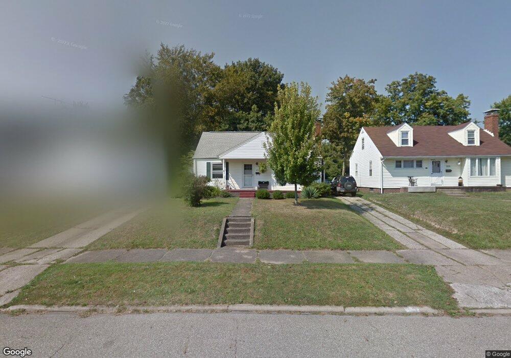
2531 Shunk Ave Alliance, OH 44601
Estimated Value: $140,000 - $183,000
2
Beds
1
Bath
1,428
Sq Ft
$114/Sq Ft
Est. Value
About This Home
This home is located at 2531 Shunk Ave, Alliance, OH 44601 and is currently estimated at $162,328, approximately $113 per square foot. 2531 Shunk Ave is a home located in Stark County with nearby schools including Alliance Elementary School at Rockhill, Alliance Intermediate School at Northside, and Alliance Middle School.
Ownership History
Date
Name
Owned For
Owner Type
Purchase Details
Closed on
Aug 3, 2006
Sold by
Saffici Christopher L and Saffici Kristin
Bought by
Wagner Debra S
Current Estimated Value
Home Financials for this Owner
Home Financials are based on the most recent Mortgage that was taken out on this home.
Original Mortgage
$78,375
Interest Rate
6.82%
Mortgage Type
Purchase Money Mortgage
Purchase Details
Closed on
Jun 8, 2006
Sold by
Hamlin Esther J and Hamlin William
Bought by
Saffici Christopher L
Home Financials for this Owner
Home Financials are based on the most recent Mortgage that was taken out on this home.
Original Mortgage
$78,375
Interest Rate
6.82%
Mortgage Type
Purchase Money Mortgage
Create a Home Valuation Report for This Property
The Home Valuation Report is an in-depth analysis detailing your home's value as well as a comparison with similar homes in the area
Home Values in the Area
Average Home Value in this Area
Purchase History
| Date | Buyer | Sale Price | Title Company |
|---|---|---|---|
| Wagner Debra S | $82,300 | Union Title Company | |
| Saffici Christopher L | $62,500 | Union Title Company |
Source: Public Records
Mortgage History
| Date | Status | Borrower | Loan Amount |
|---|---|---|---|
| Previous Owner | Wagner Debra S | $78,375 | |
| Previous Owner | Saffici Christopher L | $59,375 |
Source: Public Records
Tax History Compared to Growth
Tax History
| Year | Tax Paid | Tax Assessment Tax Assessment Total Assessment is a certain percentage of the fair market value that is determined by local assessors to be the total taxable value of land and additions on the property. | Land | Improvement |
|---|---|---|---|---|
| 2025 | -- | $47,680 | $10,470 | $37,210 |
| 2024 | -- | $47,680 | $10,470 | $37,210 |
| 2023 | $1,086 | $36,190 | $8,120 | $28,070 |
| 2022 | $1,110 | $36,190 | $8,120 | $28,070 |
| 2021 | $1,110 | $36,190 | $8,120 | $28,070 |
| 2020 | $1,363 | $31,430 | $7,070 | $24,360 |
| 2019 | $1,343 | $31,430 | $7,070 | $24,360 |
| 2018 | $1,349 | $31,430 | $7,070 | $24,360 |
| 2017 | $1,245 | $28,530 | $6,550 | $21,980 |
| 2016 | $1,055 | $23,980 | $6,550 | $17,430 |
| 2015 | $1,064 | $23,980 | $6,550 | $17,430 |
| 2014 | $1,020 | $21,880 | $5,950 | $15,930 |
| 2013 | $509 | $21,880 | $5,950 | $15,930 |
Source: Public Records
Map
Nearby Homes
- 2705 Shunk Ave
- 2839 S Rockhill Ave
- 549 Linwood Dr
- 2372 S Union Ave
- 3101 Ridgehill Ave
- 2405 Cherry Ave
- 1059 Oakwood Dr
- 236 E Milton St
- 2460 S Arch Ave
- 884 W College Rd
- 2408 S Linden Ave
- 317 E State St
- 1515 S Rockhill Ave
- 2112 Blenheim Ave
- 2195 Blenheim Ave
- 112 E College St
- 277 W Carol St
- 555 E Milton St
- 2218 S Freedom Ave
- 2376 S Seneca Ave
- 2543 Shunk Ave
- 2521 Shunk Ave
- 2553 Shunk Ave
- 2513 Shunk Ave
- 2603 Shunk Ave
- 2503 Shunk Ave
- 2550 Belleflower Dr
- 2534 Shunk Ave
- 2524 Shunk Ave
- 2544 Shunk Ave
- 2613 Shunk Ave
- 2514 Shunk Ave
- 2556 Shunk Ave
- 2490 Belleflower Dr
- 2504 Shunk Ave
- 2606 Shunk Ave
- 2614 Belleflower Dr
- 2625 Shunk Ave
- 2465 Shunk Ave
- 2616 Shunk Ave