Estimated Value: $322,000 - $391,000
3
Beds
2
Baths
1,288
Sq Ft
$276/Sq Ft
Est. Value
About This Home
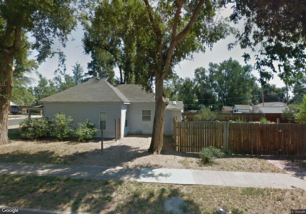
This home is located at 254 1st Ave, Ault, CO 80610 and is currently estimated at $355,393, approximately $275 per square foot. 254 1st Ave is a home located in Weld County with nearby schools including Highland Elementary School, Highland Middle School, and Highland High School.
Ownership History
Date
Name
Owned For
Owner Type
Purchase Details
Closed on
Jul 10, 2019
Sold by
Pinon Jose Alfredo and Pinon Alicia G
Bought by
Helmick Eric William and Helmick Terry Louise
Current Estimated Value
Purchase Details
Closed on
Jul 31, 2001
Sold by
Escobar Pedro and Escobar Maria S
Bought by
Pinon Jose Alfredo and Pinon Alicia G
Home Financials for this Owner
Home Financials are based on the most recent Mortgage that was taken out on this home.
Original Mortgage
$101,900
Interest Rate
7.05%
Mortgage Type
FHA
Purchase Details
Closed on
Oct 2, 1998
Sold by
Pierce Steve and Pierce Pamela Ann
Bought by
Fiolkoski Peggy Ann and Fiolkoski Paige Catherine
Home Financials for this Owner
Home Financials are based on the most recent Mortgage that was taken out on this home.
Original Mortgage
$113,497
Interest Rate
6.92%
Mortgage Type
FHA
Create a Home Valuation Report for This Property
The Home Valuation Report is an in-depth analysis detailing your home's value as well as a comparison with similar homes in the area
Purchase History
| Date | Buyer | Sale Price | Title Company |
|---|---|---|---|
| Helmick Eric William | $178,000 | First American | |
| Pinon Jose Alfredo | $103,500 | -- | |
| Fiolkoski Peggy Ann | $120,000 | Land Title |
Source: Public Records
Mortgage History
| Date | Status | Borrower | Loan Amount |
|---|---|---|---|
| Previous Owner | Pinon Jose Alfredo | $101,900 | |
| Previous Owner | Fiolkoski Peggy Ann | $113,497 |
Source: Public Records
Tax History
| Year | Tax Paid | Tax Assessment Tax Assessment Total Assessment is a certain percentage of the fair market value that is determined by local assessors to be the total taxable value of land and additions on the property. | Land | Improvement |
|---|---|---|---|---|
| 2025 | $1,098 | $18,640 | $3,500 | $15,140 |
| 2024 | $1,098 | $18,640 | $3,500 | $15,140 |
| 2023 | $894 | $18,780 | $2,840 | $15,940 |
| 2022 | $995 | $15,920 | $2,250 | $13,670 |
| 2021 | $965 | $15,080 | $2,310 | $12,770 |
| 2020 | $739 | $11,600 | $1,350 | $10,250 |
| 2019 | $780 | $11,600 | $1,350 | $10,250 |
| 2018 | $616 | $9,020 | $1,110 | $7,910 |
| 2017 | $617 | $9,020 | $1,110 | $7,910 |
| 2016 | $515 | $7,690 | $1,110 | $6,580 |
| 2015 | $517 | $7,690 | $1,110 | $6,580 |
| 2014 | $347 | $5,170 | $1,020 | $4,150 |
Source: Public Records
Map
Nearby Homes
- 301 E 1st St
- 205 S 3rd Ave
- 226 1st St
- Co Rd 104
- 212 1st St
- 112 2nd St
- 16627 Highway 14 Unit 3
- 390 Cherokee Trail
- 294 Gila Trail
- 623 Conestoga Dr
- 374 Pony Express Trail
- 603 Apex Trail
- 614 Apex Trail
- 455 Peregrine Point
- 0 County Road 86 Unit IRE1051329
- 0 County Road 86 Unit IRE1051337
- 0 County Road 86 Unit IRE1051335
- 610 Apache Trail Unit D3
- 620 Apache Trail Unit B3
- 1220 Swainson Rd
Your Personal Tour Guide
Ask me questions while you tour the home.