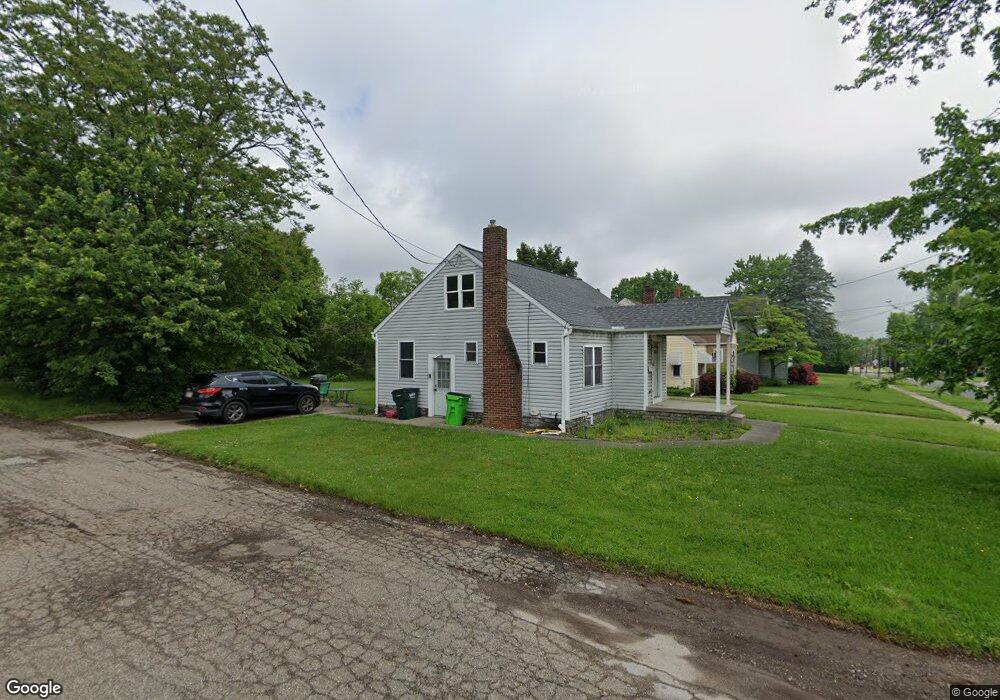
254 5th St NE Barberton, OH 44203
East Barberton NeighborhoodEstimated Value: $133,000 - $184,000
2
Beds
1
Bath
864
Sq Ft
$175/Sq Ft
Est. Value
About This Home
This home is located at 254 5th St NE, Barberton, OH 44203 and is currently estimated at $150,974, approximately $174 per square foot. 254 5th St NE is a home located in Summit County with nearby schools including Barberton Intermediate School 3-5, Barberton Middle School, and Barberton High School.
Ownership History
Date
Name
Owned For
Owner Type
Purchase Details
Closed on
Oct 4, 2016
Sold by
Murphy Scott P and Murphy Jean M
Bought by
R S Richards Llc
Current Estimated Value
Purchase Details
Closed on
Nov 21, 2006
Sold by
Beres Betty Jo and Campagna Judy K
Bought by
Murphy Scott P and Murphy Jean M
Home Financials for this Owner
Home Financials are based on the most recent Mortgage that was taken out on this home.
Original Mortgage
$36,000
Interest Rate
6.4%
Mortgage Type
Purchase Money Mortgage
Purchase Details
Closed on
Sep 24, 2004
Sold by
Estate Of Irene E Beres
Bought by
Beres Betty Jo and Campagna Judy K
Create a Home Valuation Report for This Property
The Home Valuation Report is an in-depth analysis detailing your home's value as well as a comparison with similar homes in the area
Home Values in the Area
Average Home Value in this Area
Purchase History
| Date | Buyer | Sale Price | Title Company |
|---|---|---|---|
| R S Richards Llc | $62,770 | None Available | |
| Murphy Scott P | $45,000 | None Available | |
| Beres Betty Jo | -- | -- |
Source: Public Records
Mortgage History
| Date | Status | Borrower | Loan Amount |
|---|---|---|---|
| Previous Owner | Murphy Scott P | $36,000 |
Source: Public Records
Tax History Compared to Growth
Tax History
| Year | Tax Paid | Tax Assessment Tax Assessment Total Assessment is a certain percentage of the fair market value that is determined by local assessors to be the total taxable value of land and additions on the property. | Land | Improvement |
|---|---|---|---|---|
| 2025 | $2,756 | $38,032 | $9,643 | $28,389 |
| 2024 | $1,952 | $38,032 | $9,643 | $28,389 |
| 2023 | $2,756 | $38,032 | $9,643 | $28,389 |
| 2022 | $1,531 | $25,872 | $6,559 | $19,313 |
| 2021 | $1,530 | $25,872 | $6,559 | $19,313 |
| 2020 | $1,498 | $25,870 | $6,560 | $19,310 |
| 2019 | $1,404 | $21,970 | $6,410 | $15,560 |
| 2018 | $1,383 | $21,970 | $6,410 | $15,560 |
| 2017 | $1,401 | $21,970 | $6,410 | $15,560 |
| 2016 | $1,405 | $21,970 | $6,410 | $15,560 |
| 2015 | $1,401 | $21,970 | $6,410 | $15,560 |
| 2014 | $1,278 | $20,140 | $6,410 | $13,730 |
| 2013 | $1,451 | $22,890 | $6,410 | $16,480 |
Source: Public Records
Map
Nearby Homes
- 357 E Paige Ave
- 320 Lincoln Ave Unit 322
- 412 Grandview Ave
- 334 E Tuscarawas Ave
- 414 E Baird Ave
- 653 Washington Ave
- 477 Robinson Ave
- 327 Robinson Ave
- 650 E Tuscarawas Ave
- 261 E State St
- 613 Wooster Rd N
- 46 Brown St
- 0 Wooster Rd N
- 442 Wooster Rd N
- 25 S Van Buren Ave
- 44 W Summit St
- 43 S Van Buren Ave
- 251 Slate Ridge Dr
- 1110 Mansion Dr
- 588 Austin Dr
- 260 5th St NE
- 423 E Hopocan Ave
- 244 5th St NE
- 264 5th St NE
- 417 E Hopocan Ave
- 238 5th St NE
- 270 5th St NE
- 424 E Hopocan Ave
- 259 5th St NE
- 413 E Hopocan Ave
- 418 E Hopocan Ave
- 426 E Huston St
- 245 5th St NE
- 276 5th St NE
- 265 5th St NE
- 412 E Hopocan Ave
- 412 E Hopocan Ave
- 239 5th St NE
- 271 5th St NE
- 409 E Hopocan Ave