
Seller's Agent in 2025
Jaeh Korwitts
Compass
(630) 430-9566
4 in this area
102 Total Sales

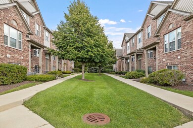
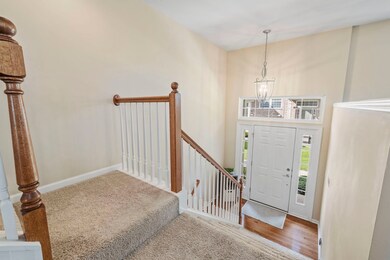
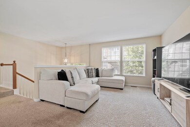
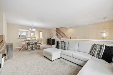
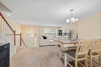
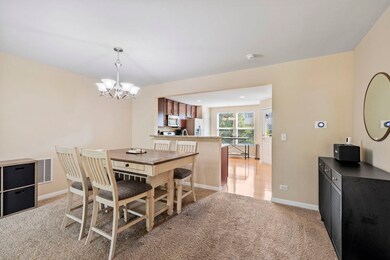
Welcome to this inviting 3-bedroom, 2.5-bathroom townhome in the highly sought-after Prescott Mill Community. The open-concept design offers a spacious kitchen with plenty of cabinet space, flowing seamlessly into the living and dining areas-ideal for entertaining or family gatherings. Recent upgrades include a new Furnace, Air Conditioner and Dishwasher (2025), giving you peace of mind for years to come. Upstairs, you'll find an expansive Primary Suite with a Large Walk-in Closet to match. Prescott Mill is known for its tranquil setting with walking trails, parks, and green spaces, while still being close to shopping, dining, and top-rated schools. With its move-in ready condition and prime location, this home truly has it all.
| Date | Type | Sale Price | Title Company |
|---|---|---|---|
| Warranty Deed | $335,000 | Chicago Title | |
| Warranty Deed | $196,500 | Wheatland Title Guaranty | |
| Sheriffs Deed | $131,041 | None Available | |
| Special Warranty Deed | $185,500 | None Available |
| Date | Status | Loan Amount | Loan Type |
|---|---|---|---|
| Open | $268,000 | New Conventional | |
| Previous Owner | $137,550 | Purchase Money Mortgage | |
| Previous Owner | $182,057 | FHA |
| Date | Event | Price | List to Sale | Price per Sq Ft |
|---|---|---|---|---|
| 10/02/2025 10/02/25 | Sold | $335,000 | 0.0% | $169 / Sq Ft |
| 09/02/2025 09/02/25 | Pending | -- | -- | -- |
| 08/29/2025 08/29/25 | For Sale | $335,000 | -- | $169 / Sq Ft |
| Year | Tax Paid | Tax Assessment Tax Assessment Total Assessment is a certain percentage of the fair market value that is determined by local assessors to be the total taxable value of land and additions on the property. | Land | Improvement |
|---|---|---|---|---|
| 2024 | $6,771 | $90,139 | $10,446 | $79,693 |
| 2023 | $6,007 | $79,769 | $9,244 | $70,525 |
| 2022 | $6,007 | $72,518 | $8,404 | $64,114 |
| 2021 | $6,026 | $70,406 | $8,159 | $62,247 |
| 2020 | $5,955 | $69,025 | $7,999 | $61,026 |
| 2019 | $5,992 | $68,421 | $7,999 | $60,422 |
| 2018 | $6,523 | $70,175 | $8,944 | $61,231 |
| 2017 | $6,630 | $64,677 | $8,243 | $56,434 |
| 2016 | $6,229 | $59,886 | $7,632 | $52,254 |
| 2015 | $5,394 | $55,450 | $7,067 | $48,383 |
| 2014 | -- | $57,165 | $7,286 | $49,879 |
| 2013 | -- | $60,173 | $7,669 | $52,504 |
Seller's Agent in 2025
Jaeh Korwitts
Compass
(630) 430-9566
4 in this area
102 Total Sales
Buyer's Agent in 2025
Oleg Baliuk
KOMAR
(312) 900-9797
1 in this area
239 Total Sales
Source: Midwest Real Estate Data (MRED)
MLS Number: 12457453
APN: 03-12-401-149
Disclaimer: Certain information contained herein is derived from information provided by parties other than Homes.com. All information provided is deemed reliable, but is not guaranteed to be accurate and should be independently verified.
![]() Based on information submitted to the MLS GRID. All data is obtained from various sources and may not have been verified by broker or MLS GRID. Supplied Open House Information is subject to change without notice. All information should be independently reviewed and verified for accuracy. Properties may or may not be listed by the office/agent presenting the information. Some IDX listings have been excluded from this website.
Based on information submitted to the MLS GRID. All data is obtained from various sources and may not have been verified by broker or MLS GRID. Supplied Open House Information is subject to change without notice. All information should be independently reviewed and verified for accuracy. Properties may or may not be listed by the office/agent presenting the information. Some IDX listings have been excluded from this website.
Based on information submitted to the MLS GRID
Ask me questions while you tour the home.