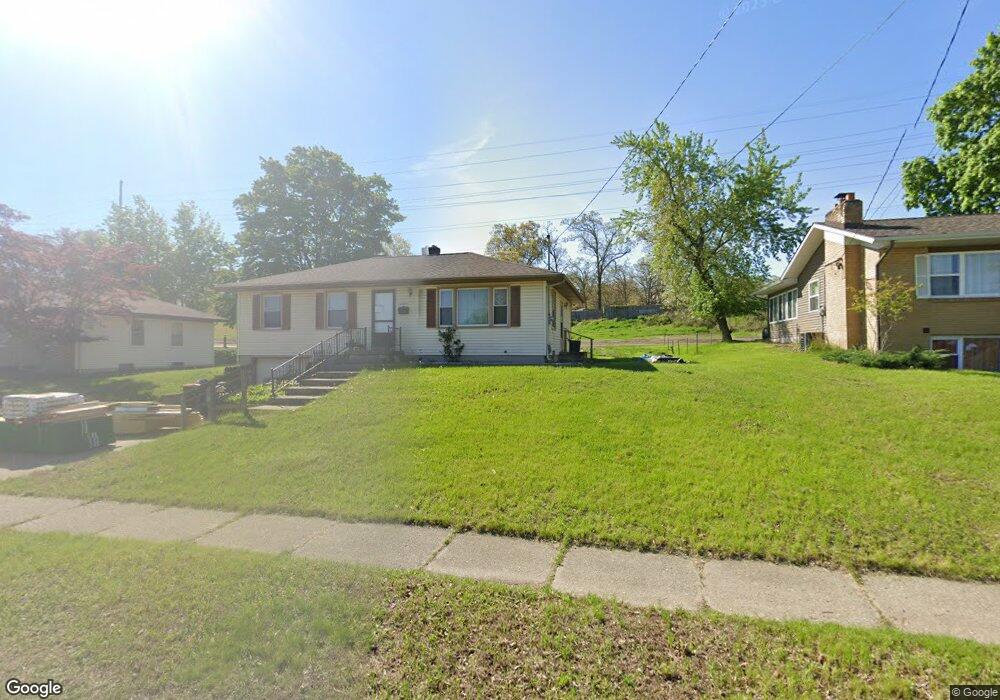
2544 Michael Ave SW Wyoming, MI 49509
Urbandale NeighborhoodEstimated Value: $247,268 - $267,000
3
Beds
1
Bath
1,040
Sq Ft
$249/Sq Ft
Est. Value
About This Home
This home is located at 2544 Michael Ave SW, Wyoming, MI 49509 and is currently estimated at $258,567, approximately $248 per square foot. 2544 Michael Ave SW is a home located in Kent County with nearby schools including Oriole Park Elementary School, Wyoming Intermediate School, and Parkview Elementary School.
Ownership History
Date
Name
Owned For
Owner Type
Purchase Details
Closed on
Aug 14, 2020
Sold by
Virginia A Banno Revocable Living Trust
Bought by
Banno Robert G and Banno James M
Current Estimated Value
Home Financials for this Owner
Home Financials are based on the most recent Mortgage that was taken out on this home.
Original Mortgage
$78,600
Outstanding Balance
$55,687
Interest Rate
2.9%
Mortgage Type
New Conventional
Estimated Equity
$202,880
Purchase Details
Closed on
Jul 27, 2016
Sold by
Banno Virginia A
Bought by
Banno Virginia A and The Virginia A Banno Revocable
Create a Home Valuation Report for This Property
The Home Valuation Report is an in-depth analysis detailing your home's value as well as a comparison with similar homes in the area
Home Values in the Area
Average Home Value in this Area
Purchase History
| Date | Buyer | Sale Price | Title Company |
|---|---|---|---|
| Banno Robert G | -- | None Listed On Document | |
| Banno Robert G | -- | None Available | |
| Banno Virginia A | -- | Attorney |
Source: Public Records
Mortgage History
| Date | Status | Borrower | Loan Amount |
|---|---|---|---|
| Open | Banno Robert G | $78,600 | |
| Closed | Banno Robert G | $78,600 |
Source: Public Records
Tax History Compared to Growth
Tax History
| Year | Tax Paid | Tax Assessment Tax Assessment Total Assessment is a certain percentage of the fair market value that is determined by local assessors to be the total taxable value of land and additions on the property. | Land | Improvement |
|---|---|---|---|---|
| 2025 | $1,726 | $110,100 | $0 | $0 |
| 2024 | $1,726 | $100,100 | $0 | $0 |
| 2023 | $1,681 | $87,500 | $0 | $0 |
| 2022 | $1,644 | $80,500 | $0 | $0 |
| 2021 | $4,258 | $74,500 | $0 | $0 |
| 2020 | $1,465 | $69,100 | $0 | $0 |
| 2019 | $1,570 | $60,900 | $0 | $0 |
| 2018 | $1,541 | $54,900 | $0 | $0 |
| 2017 | $1,502 | $0 | $0 | $0 |
| 2016 | $0 | $0 | $0 | $0 |
| 2015 | -- | $0 | $0 | $0 |
| 2013 | -- | $0 | $0 | $0 |
Source: Public Records
Map
Nearby Homes
- 2517 Newstead Ave SW
- 2621 Doncaster Ave SW
- 2713 Madelyn Dr SW
- 2620 Riley Ave SW
- 818 Aldon St SW
- 2746 Tennyson Dr SW
- 2101 Godfrey Ave SW
- 2107 Huizen Ave SW
- 886 Belfield St SW Unit 7
- 2151 Banner Dr SW Unit F
- 1260 Cricklewood St SW
- 2140 Banner Dr SW
- 2185 Clyde Park Ave SW
- 2541 Noel Ave SW
- 2050 Arnold Ave SW
- 918 Buckingham St SW
- 922 Burton St SW
- 1955 Hendricks Ave SW
- 2812 Longstreet Ave SW
- 1946 Martindale Ave SW
- 2552 Michael Ave SW
- 2538 Michael Ave SW
- 2550 de Hoop Ave SW
- 2545 Michael Ave SW
- 2533 Michael Ave SW
- 2532 Michael Ave SW
- 2530 de Hoop Ave SW
- 2517 Michael Ave SW
- 2526 Michael Ave SW
- 2522 de Hoop Ave SW
- 1131 Locksley Dr SW
- 1135 Locksley Dr SW
- 1129 Locksley Dr SW
- 2520 Michael Ave SW
- 2511 Michael Ave SW
- 1141 Locksley Dr SW
- 1123 Locksley Dr SW
- 2516 de Hoop Ave SW
- 1117 Locksley Dr SW
- 1149 Locksley Dr SW