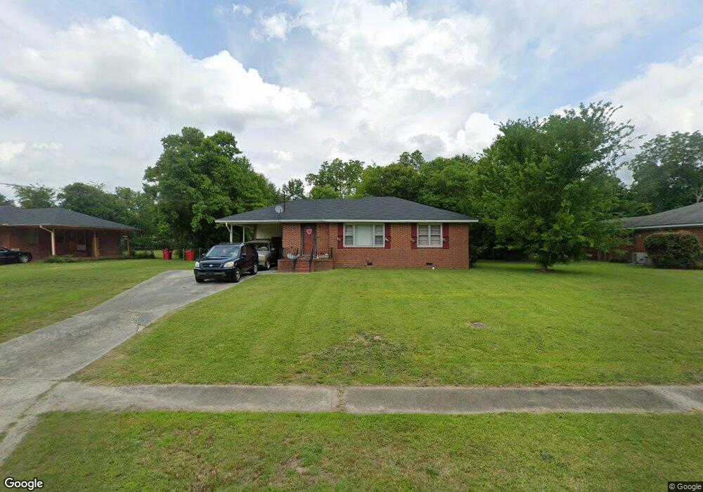
2545 Locksley Dr Macon, GA 31206
Estimated Value: $85,000 - $113,000
2
Beds
1
Bath
1,016
Sq Ft
$99/Sq Ft
Est. Value
About This Home
This home is located at 2545 Locksley Dr, Macon, GA 31206 and is currently estimated at $100,729, approximately $99 per square foot. 2545 Locksley Dr is a home located in Bibb County with nearby schools including Veterans Elementary School, Southwest High School, and Gilead Christian Academy.
Ownership History
Date
Name
Owned For
Owner Type
Purchase Details
Closed on
Apr 24, 2008
Sold by
Rbc Bank Usa
Bought by
Wilson Thomas Darryl
Current Estimated Value
Purchase Details
Closed on
Mar 4, 2008
Sold by
Early Gregory C
Bought by
Rbc Centura Bank
Purchase Details
Closed on
Dec 19, 2007
Sold by
Early Gregory
Bought by
Gearly Properties Llc
Purchase Details
Closed on
Nov 30, 2006
Sold by
Wilson T Darryl
Bought by
Early Gregory C
Purchase Details
Closed on
Aug 10, 2006
Create a Home Valuation Report for This Property
The Home Valuation Report is an in-depth analysis detailing your home's value as well as a comparison with similar homes in the area
Home Values in the Area
Average Home Value in this Area
Purchase History
| Date | Buyer | Sale Price | Title Company |
|---|---|---|---|
| Wilson Thomas Darryl | $38,500 | None Available | |
| Rbc Centura Bank | $58,331 | None Available | |
| Gearly Properties Llc | -- | None Available | |
| Early Gregory C | $60,000 | None Avilabale | |
| -- | $42,600 | -- | |
| Wilson T Darryl | $42,625 | None Avilebel |
Source: Public Records
Tax History Compared to Growth
Tax History
| Year | Tax Paid | Tax Assessment Tax Assessment Total Assessment is a certain percentage of the fair market value that is determined by local assessors to be the total taxable value of land and additions on the property. | Land | Improvement |
|---|---|---|---|---|
| 2025 | $825 | $33,575 | $6,072 | $27,503 |
| 2024 | $817 | $32,171 | $5,808 | $26,363 |
| 2023 | $556 | $21,893 | $2,370 | $19,523 |
| 2022 | $611 | $17,646 | $3,286 | $14,360 |
| 2021 | $671 | $17,646 | $3,286 | $14,360 |
| 2020 | $505 | $13,016 | $2,958 | $10,058 |
| 2019 | $540 | $13,782 | $2,958 | $10,824 |
| 2018 | $1,006 | $13,782 | $2,958 | $10,824 |
| 2017 | $516 | $13,782 | $2,958 | $10,824 |
| 2016 | $473 | $13,679 | $2,958 | $10,721 |
| 2015 | $782 | $15,976 | $2,958 | $13,018 |
| 2014 | $977 | $17,356 | $4,337 | $13,018 |
Source: Public Records
Map
Nearby Homes
- 2443 Lambert Dr
- 2521 Rocky Creek Rd
- 2995 Virginia Dr
- 2765 Alden St
- 2868 Barrett Ave
- 4241 Pinedale Dr
- 4249 Elkan Ave
- 2770 Bonnie Ave
- 2769 Nancy Dr
- 2768 Nancy Dr
- 2704 Reynolds Dr
- 140 Spencer Hill Ct
- 2431 Vivian Dr
- 3913 Blair Ct
- 4738 Bloomfield Rd
- 3607 Pineland Trail
- 4496 Thrasher Cir
- 5711 Sterling Place
- 2465 Thrasher Ave
- 2539 Locksley Dr
- 2557 Locksley Dr
- 2552 Allan Way
- 2533 Locksley Dr
- 2546 Allan Way
- 2560 Allan Way
- 2570 Allan Way
- 2578 Allan Way
- 2546 Locksley Dr
- 2540 Locksley Dr
- 2540 Allan Way
- 2554 Locksley Dr
- 2527 Locksley Dr
- 2534 Locksley Dr
- 2570 Locksley Dr
- 2562 Locksley Dr
- 2534 Allan Way
- 2528 Locksley Dr
- 2521 Locksley Dr
- 2555 Allan Way