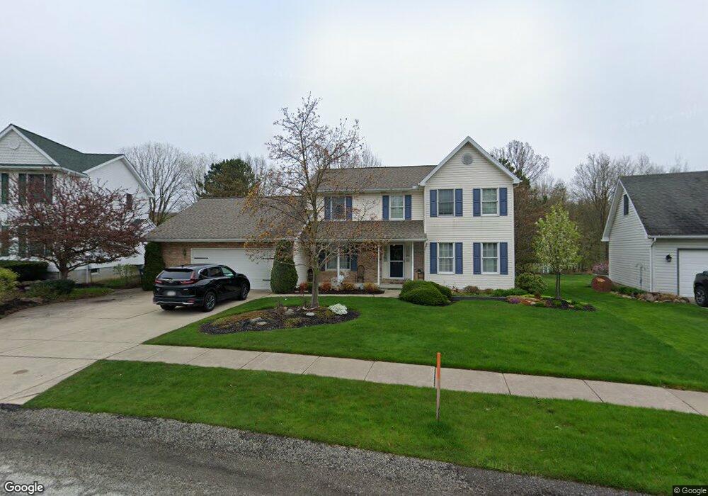
2549 Brooksboro Dr Erie, PA 16510
Millcreek NeighborhoodEstimated Value: $424,000 - $501,000
4
Beds
3
Baths
2,420
Sq Ft
$189/Sq Ft
Est. Value
About This Home
This home is located at 2549 Brooksboro Dr, Erie, PA 16510 and is currently estimated at $457,052, approximately $188 per square foot. 2549 Brooksboro Dr is a home located in Erie County with nearby schools including Belle Valley Elementary School, McDowell High School, and James S. Wilson Middle School.
Ownership History
Date
Name
Owned For
Owner Type
Purchase Details
Closed on
Aug 30, 2023
Sold by
Kuhn Joseph M and Kuhn Sharon A
Bought by
Rai Tabita and Tamang Tshring
Current Estimated Value
Home Financials for this Owner
Home Financials are based on the most recent Mortgage that was taken out on this home.
Original Mortgage
$311,200
Outstanding Balance
$304,374
Interest Rate
6.78%
Mortgage Type
New Conventional
Estimated Equity
$152,678
Create a Home Valuation Report for This Property
The Home Valuation Report is an in-depth analysis detailing your home's value as well as a comparison with similar homes in the area
Home Values in the Area
Average Home Value in this Area
Purchase History
| Date | Buyer | Sale Price | Title Company |
|---|---|---|---|
| Rai Tabita | $389,000 | None Listed On Document |
Source: Public Records
Mortgage History
| Date | Status | Borrower | Loan Amount |
|---|---|---|---|
| Open | Rai Tabita | $311,200 |
Source: Public Records
Tax History Compared to Growth
Tax History
| Year | Tax Paid | Tax Assessment Tax Assessment Total Assessment is a certain percentage of the fair market value that is determined by local assessors to be the total taxable value of land and additions on the property. | Land | Improvement |
|---|---|---|---|---|
| 2025 | $6,773 | $246,450 | $58,100 | $188,350 |
| 2024 | $6,596 | $246,450 | $58,100 | $188,350 |
| 2023 | $6,227 | $246,450 | $58,100 | $188,350 |
| 2022 | $5,983 | $246,450 | $58,100 | $188,350 |
| 2021 | $5,918 | $246,450 | $58,100 | $188,350 |
| 2020 | $5,857 | $246,450 | $58,100 | $188,350 |
| 2019 | $5,759 | $246,450 | $58,100 | $188,350 |
| 2018 | $5,617 | $246,450 | $58,100 | $188,350 |
| 2017 | $5,605 | $246,450 | $58,100 | $188,350 |
| 2016 | $6,510 | $246,450 | $58,100 | $188,350 |
| 2015 | $6,510 | $0 | $0 | $0 |
| 2014 | $2,091 | $246,450 | $58,100 | $188,350 |
Source: Public Records
Map
Nearby Homes
- 4816 Avellino Dr
- 2554 Pepper Tree Dr
- 2738 E 44th St
- 4309 Koehler Rd
- 3950 Rice Ave
- 4030 Mcclelland Ave
- 2034 E Gore Rd
- 2259 E 38th St
- 2227 E 38th St
- 0 Conrad Rd
- 4315 Fargo St
- 2021 E 38th St
- 2345 Wager Rd
- 4206 Stanton St
- 2603 E 32nd St
- 2739 E 31st St
- 2839 E 30th St
- 2855 E 30th St
- 2844 E 30th St
- 3816 Stanton St
- 2551 Brooksboro Dr
- 2545 Brooksboro Dr
- 2541 Brooksboro Dr
- 2548 Brooksboro Dr
- 2555 Brooksboro Dr
- 2554 Brooksboro Dr
- 2542 Brooksboro Dr
- 2535 Brooksboro Dr
- 4838 Koehler Rd
- 2536 Brooksboro Dr
- 2558 Brooksboro Dr
- 2543 Wintergreen Dr
- 2549 Wintergreen Dr
- 2531 Brooksboro Dr
- 2532 Brooksboro Dr
- 2537 Wintergreen Dr
- 4837 Koehler Rd
- 4827 Koehler Rd
- 4855 Avellino Dr
- 2553 Wintergreen Dr