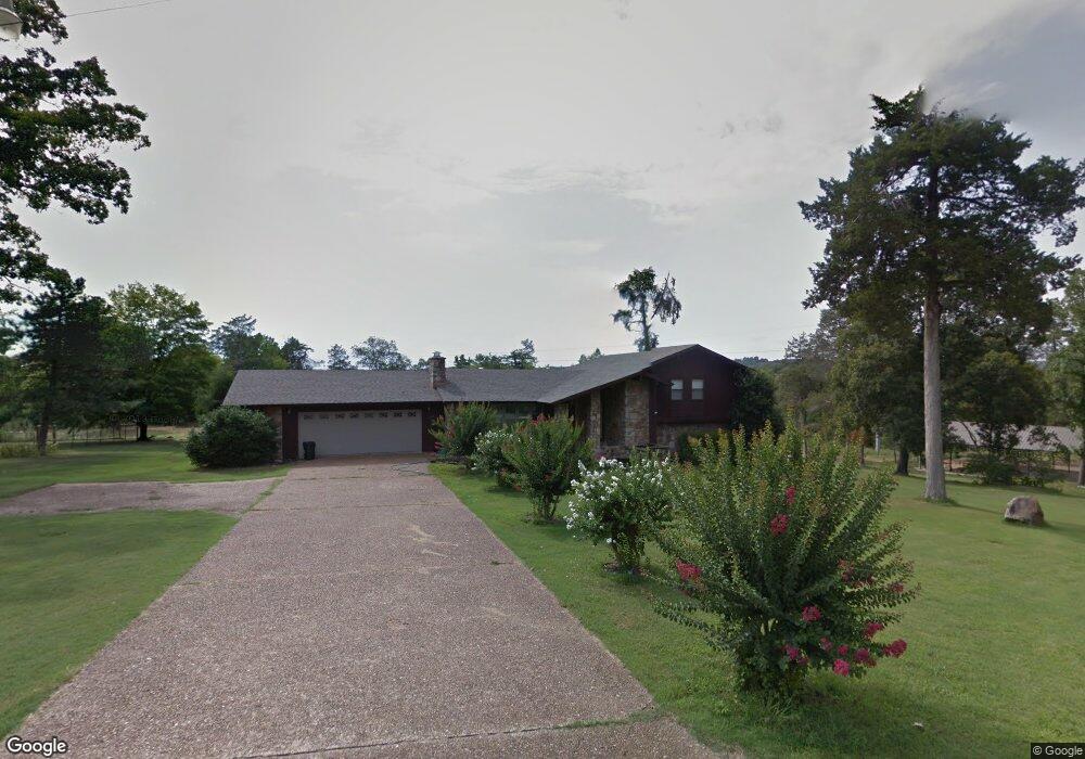
255 Cedarwood 1o9erh3ydoay Batesville, AR 72501
Estimated Value: $252,000 - $463,472
--
Bed
3
Baths
3,191
Sq Ft
$112/Sq Ft
Est. Value
About This Home
This home is located at 255 Cedarwood 1o9erh3ydoay, Batesville, AR 72501 and is currently estimated at $357,118, approximately $111 per square foot. 255 Cedarwood 1o9erh3ydoay is a home located in Independence County with nearby schools including Batesville Junior High School, Batesville High School, and Hope Lutheran School.
Ownership History
Date
Name
Owned For
Owner Type
Purchase Details
Closed on
Sep 29, 2023
Sold by
Stalker Amanda Beth
Bought by
Stalker Steven Todd
Current Estimated Value
Purchase Details
Closed on
Jul 12, 2020
Sold by
Stalker Steven Todd and The Stalker Family Trust
Bought by
Stalker Steven Todd
Home Financials for this Owner
Home Financials are based on the most recent Mortgage that was taken out on this home.
Original Mortgage
$310,800
Interest Rate
2.7%
Mortgage Type
VA
Purchase Details
Closed on
Feb 12, 2007
Bought by
Stalker Steven Todd and Candice Susanne Stalker
Purchase Details
Closed on
May 31, 2002
Sold by
Stalker Candice
Bought by
Stalker Steven Todd
Purchase Details
Closed on
Jul 8, 1998
Bought by
Ruggeri Stephen E
Create a Home Valuation Report for This Property
The Home Valuation Report is an in-depth analysis detailing your home's value as well as a comparison with similar homes in the area
Home Values in the Area
Average Home Value in this Area
Purchase History
| Date | Buyer | Sale Price | Title Company |
|---|---|---|---|
| Stalker Steven Todd | -- | None Listed On Document | |
| Stalker Steven Todd | -- | None Listed On Document | |
| Stalker Steven Todd | -- | None Available | |
| Stalker Steven Todd | -- | -- | |
| Stalker Steven Todd | $129,000 | -- | |
| Stalker Steven Todd | $129,000 | -- | |
| Ruggeri Stephen E | $122,000 | -- |
Source: Public Records
Mortgage History
| Date | Status | Borrower | Loan Amount |
|---|---|---|---|
| Previous Owner | Stalker Steven Todd | $310,800 |
Source: Public Records
Tax History Compared to Growth
Tax History
| Year | Tax Paid | Tax Assessment Tax Assessment Total Assessment is a certain percentage of the fair market value that is determined by local assessors to be the total taxable value of land and additions on the property. | Land | Improvement |
|---|---|---|---|---|
| 2024 | $3,050 | $66,540 | $7,890 | $58,650 |
| 2023 | $3,125 | $66,540 | $7,890 | $58,650 |
| 2022 | $3,175 | $66,540 | $7,890 | $58,650 |
| 2021 | $1,188 | $29,300 | $1,380 | $27,920 |
| 2020 | $1,563 | $29,300 | $1,380 | $27,920 |
| 2019 | $1,450 | $27,180 | $960 | $26,220 |
| 2018 | $1,450 | $27,180 | $960 | $26,220 |
| 2017 | $1,434 | $27,180 | $960 | $26,220 |
| 2016 | $1,084 | $27,180 | $960 | $26,220 |
| 2015 | $1,073 | $27,180 | $960 | $26,220 |
| 2014 | $1,478 | $28,020 | $2,650 | $25,370 |
Source: Public Records
Map
Nearby Homes
- 255 Cedarwood Dr
- 260 Cedarwood Dr
- 250 Cedarwood Dr
- 00 Camp Tahkodah Rd
- 245 Cedarwood Dr
- 0 Cedarwood Dr Unit 7-373
- 0 Cedarwood Dr Unit 8-494
- 000 Cedarwood Dr
- 0 Cedarwood Dr
- 1295 Marywood Dr
- 1225 Marywood Dr
- 1225 Marywood Dr
- 000 N Saint Louis
- 4700 blk N Saint Louis
- 6920 N Saint Louis
- 0 N Saint Louis
- 1215 Marywood Dr
- 1215 Marywood Dr
- 1205 Marywood Dr
- 180 George St