Estimated Value: $165,435 - $283,000
1
Bed
1
Bath
656
Sq Ft
$341/Sq Ft
Est. Value
About This Home
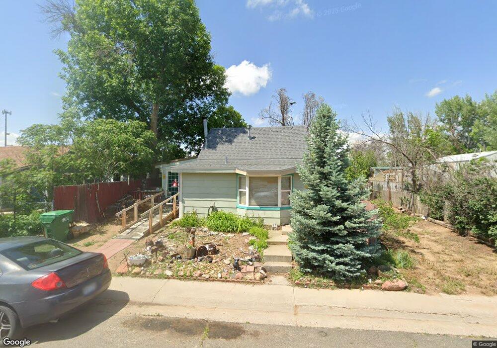
This home is located at 255 E 4th St, Ault, CO 80610 and is currently estimated at $223,859, approximately $341 per square foot. 255 E 4th St is a home with nearby schools including Highland Elementary School, Highland Middle School, and Highland High School.
Ownership History
Date
Name
Owned For
Owner Type
Purchase Details
Closed on
Oct 28, 1999
Sold by
Sehestedt Marlene R and Sehestedt Dale R
Bought by
Smith Paul G and Smith Anna
Current Estimated Value
Home Financials for this Owner
Home Financials are based on the most recent Mortgage that was taken out on this home.
Original Mortgage
$62,000
Outstanding Balance
$19,073
Interest Rate
7.85%
Estimated Equity
$204,786
Purchase Details
Closed on
May 20, 1998
Sold by
Renfro Albert W Living Trust
Bought by
Sehestedt Marlene and Sehestedt Dale R
Home Financials for this Owner
Home Financials are based on the most recent Mortgage that was taken out on this home.
Original Mortgage
$38,950
Interest Rate
7.22%
Purchase Details
Closed on
Apr 7, 1987
Purchase Details
Closed on
Apr 3, 1987
Purchase Details
Closed on
Jan 25, 1980
Purchase Details
Closed on
Jan 1, 1975
Create a Home Valuation Report for This Property
The Home Valuation Report is an in-depth analysis detailing your home's value as well as a comparison with similar homes in the area
Purchase History
| Date | Buyer | Sale Price | Title Company |
|---|---|---|---|
| Smith Paul G | $60,000 | -- | |
| Sehestedt Marlene | $41,000 | -- | |
| -- | -- | -- | |
| -- | -- | -- | |
| -- | -- | -- | |
| -- | -- | -- |
Source: Public Records
Mortgage History
| Date | Status | Borrower | Loan Amount |
|---|---|---|---|
| Open | Smith Paul G | $62,000 | |
| Previous Owner | Sehestedt Marlene | $38,950 |
Source: Public Records
Tax History
| Year | Tax Paid | Tax Assessment Tax Assessment Total Assessment is a certain percentage of the fair market value that is determined by local assessors to be the total taxable value of land and additions on the property. | Land | Improvement |
|---|---|---|---|---|
| 2025 | $142 | $8,330 | $2,800 | $5,530 |
| 2024 | $142 | $8,330 | $2,800 | $5,530 |
| 2023 | $116 | $7,620 | $2,130 | $5,490 |
| 2022 | $161 | $5,160 | $840 | $4,320 |
| 2021 | $170 | $5,310 | $870 | $4,440 |
| 2020 | $154 | $4,850 | $510 | $4,340 |
| 2019 | $163 | $4,850 | $510 | $4,340 |
| 2018 | $121 | $3,550 | $420 | $3,130 |
| 2017 | $243 | $3,550 | $420 | $3,130 |
| 2016 | $134 | $2,000 | $420 | $1,580 |
| 2015 | $134 | $2,000 | $420 | $1,580 |
| 2014 | $79 | $1,180 | $200 | $980 |
Source: Public Records
Map
Nearby Homes
- 301 E 1st St
- Co Rd 104
- 226 1st St
- 212 1st St
- 112 2nd St
- 205 S 3rd Ave
- 390 Cherokee Trail
- 623 Conestoga Dr
- 603 Apex Trail
- 16627 Highway 14 Unit 3
- 294 Gila Trail
- 614 Apex Trail
- 374 Pony Express Trail
- 0 County Road 86 Unit IRE1051329
- 0 County Road 86 Unit IRE1051337
- 0 County Road 86 Unit IRE1051335
- 610 Apache Trail Unit D3
- 620 Apache Trail Unit B3
- 455 Peregrine Point
- 655 Red Tail Dr
Your Personal Tour Guide
Ask me questions while you tour the home.