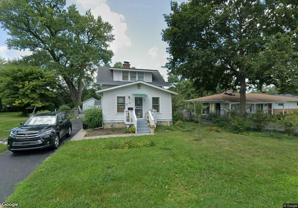
255 Maple Dr Columbus, OH 43228
Estimated Value: $191,000 - $197,115
2
Beds
1
Bath
1,120
Sq Ft
$174/Sq Ft
Est. Value
About This Home
This home is located at 255 Maple Dr, Columbus, OH 43228 and is currently estimated at $194,779, approximately $173 per square foot. 255 Maple Dr is a home located in Franklin County with nearby schools including Prairie Lincoln Elementary School, Galloway Ridge Intermediate School, and Norton Middle School.
Ownership History
Date
Name
Owned For
Owner Type
Purchase Details
Closed on
Mar 3, 2025
Sold by
Culbertson Tanya Devans
Bought by
Westan Living Trust and Culbertson
Current Estimated Value
Purchase Details
Closed on
Sep 13, 2004
Sold by
Griggs Stanley E and Griggs Cleo D
Bought by
Culbertson Tanya Devans
Purchase Details
Closed on
Aug 4, 1972
Bought by
Griggs Stanley E
Create a Home Valuation Report for This Property
The Home Valuation Report is an in-depth analysis detailing your home's value as well as a comparison with similar homes in the area
Home Values in the Area
Average Home Value in this Area
Purchase History
| Date | Buyer | Sale Price | Title Company |
|---|---|---|---|
| Westan Living Trust | -- | None Listed On Document | |
| Culbertson Tanya Devans | -- | -- | |
| Griggs Stanley E | -- | -- |
Source: Public Records
Tax History
| Year | Tax Paid | Tax Assessment Tax Assessment Total Assessment is a certain percentage of the fair market value that is determined by local assessors to be the total taxable value of land and additions on the property. | Land | Improvement |
|---|---|---|---|---|
| 2025 | $2,643 | $56,910 | $14,630 | $42,280 |
| 2024 | $2,643 | $56,910 | $14,630 | $42,280 |
| 2023 | $2,680 | $56,910 | $14,630 | $42,280 |
| 2022 | $1,597 | $25,100 | $3,750 | $21,350 |
| 2021 | $1,622 | $25,100 | $3,750 | $21,350 |
| 2020 | $1,025 | $25,100 | $3,750 | $21,350 |
| 2019 | $877 | $20,940 | $3,120 | $17,820 |
| 2018 | $1,193 | $20,940 | $3,120 | $17,820 |
| 2017 | $836 | $20,940 | $3,120 | $17,820 |
| 2016 | $1,520 | $19,920 | $4,200 | $15,720 |
| 2015 | $1,520 | $19,920 | $4,200 | $15,720 |
| 2014 | $1,498 | $19,920 | $4,200 | $15,720 |
| 2013 | $894 | $23,415 | $4,935 | $18,480 |
Source: Public Records
Map
Nearby Homes
- 154 Maple Dr
- 381 Pasadena Ave
- 396 Pasadena Ave
- 185 Sturbridge Rd
- 443 Lawrence Ave
- 69 Lawrence Ave
- 5409 Longworth Dr
- 110 Inah Ave
- 89 Postle Blvd
- 463 Darbyhurst Rd
- 417 Revere Ct
- 97 Tarryton Ct W Unit 19-H
- 87 Tarryton Ct W Unit 18D
- 5713 Larksdale Dr
- 129 Beacon Run W Unit 21C
- 399 Carilla Ln
- 376 Galloway Ridge Dr
- 4723 Tarryton Ct S Unit 14-E
- 102 Redmond Rd
- 218 Darbyhurst Rd
Your Personal Tour Guide
Ask me questions while you tour the home.