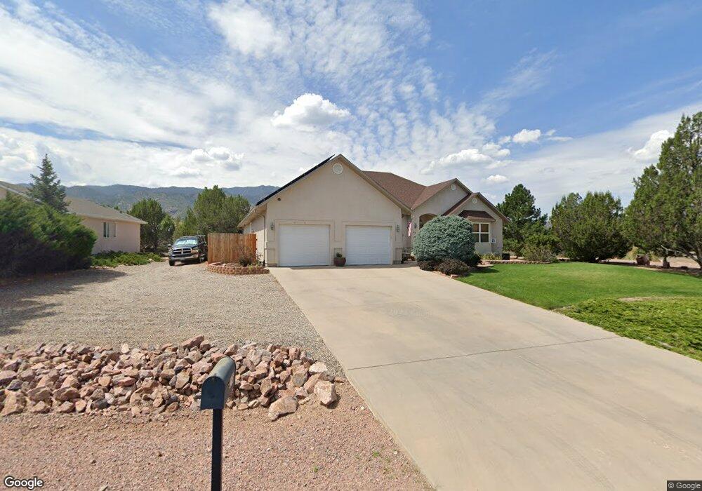
255 Savage Loop Cañon City, CO 81212
Estimated Value: $523,370 - $787,000
3
Beds
3
Baths
2,762
Sq Ft
$232/Sq Ft
Est. Value
About This Home
This home is located at 255 Savage Loop, Cañon City, CO 81212 and is currently estimated at $641,843, approximately $232 per square foot. 255 Savage Loop is a home located in Fremont County with nearby schools including Lincoln School of Science & Technology, Canon City Middle School, and Canon City High School.
Ownership History
Date
Name
Owned For
Owner Type
Purchase Details
Closed on
Oct 18, 2013
Sold by
Moon W Michael and Moon Valerie R
Bought by
Richardson Deal W and Richardson Keri M
Current Estimated Value
Home Financials for this Owner
Home Financials are based on the most recent Mortgage that was taken out on this home.
Original Mortgage
$332,626
Outstanding Balance
$251,007
Interest Rate
4.61%
Mortgage Type
VA
Estimated Equity
$390,836
Purchase Details
Closed on
Nov 30, 1998
Sold by
Murphy
Bought by
Moon
Purchase Details
Closed on
May 27, 1998
Sold by
Moon
Bought by
Murphy
Create a Home Valuation Report for This Property
The Home Valuation Report is an in-depth analysis detailing your home's value as well as a comparison with similar homes in the area
Home Values in the Area
Average Home Value in this Area
Purchase History
| Date | Buyer | Sale Price | Title Company |
|---|---|---|---|
| Richardson Deal W | $322,000 | Fidelity National Title Co | |
| Moon | $193,500 | -- | |
| Murphy | $32,000 | -- | |
| Moon | -- | -- |
Source: Public Records
Mortgage History
| Date | Status | Borrower | Loan Amount |
|---|---|---|---|
| Open | Richardson Deal W | $332,626 |
Source: Public Records
Tax History Compared to Growth
Tax History
| Year | Tax Paid | Tax Assessment Tax Assessment Total Assessment is a certain percentage of the fair market value that is determined by local assessors to be the total taxable value of land and additions on the property. | Land | Improvement |
|---|---|---|---|---|
| 2024 | $2,688 | $34,036 | $0 | $0 |
| 2023 | $2,688 | $30,351 | $0 | $0 |
| 2022 | $2,547 | $29,344 | $0 | $0 |
| 2021 | $2,553 | $30,189 | $0 | $0 |
| 2020 | $2,087 | $24,847 | $0 | $0 |
| 2019 | $2,061 | $24,847 | $0 | $0 |
| 2018 | $1,937 | $22,774 | $0 | $0 |
| 2017 | $1,667 | $22,774 | $0 | $0 |
| 2016 | $1,639 | $22,390 | $0 | $0 |
| 2015 | $1,636 | $22,390 | $0 | $0 |
| 2012 | $1,595 | $22,899 | $3,980 | $18,919 |
Source: Public Records
Map
Nearby Homes
- 265 Pelage Ct
- 207 Savage Loop
- 200 Wolf Cub Trail
- 206 Wolf Cub Trail
- TBD Forge Rd
- 1751 Forge Rd
- 133 Blue Grouse Dr
- 121 Mourning Dove Dr
- 159 Blue Grouse Dr
- 29 Kyndra Ct
- 98 Wild Rose Dr
- TBD Wild Rose Dr
- 58 Wild Rose Dr
- 147 Mourning Dove Dr
- 105 Bobwhite Loop
- 123 Wild Rose Dr
- 28 Eagle Crest Dr
- 46 Wild Rose Dr
- 34 Wild Rose Dr
- 269 Savage Loop
- 244 Wolf Cub Trail
- 281 Savage Loop
- 254 Pelage Ct
- 278 Savage Loop
- 245 Wolf Cub Trail
- 236 Wolf Cub Trail
- 41 Luna Ct
- 49 Luna Ct
- 251 Pelage Ct
- 239 Savage Loop
- 257 Pelage Ct
- 239 Wolf Cub Trail
- 115 Gere Ct
- 295 Savage Loop
- 228 Wolf Cub Trail
- 110 Gere Ct
- 46 Luna Ct
- 231 Wolf Cub Trail
- 225 Savage Loop