Estimated Value: $213,000 - $251,000
4
Beds
2
Baths
1,998
Sq Ft
$117/Sq Ft
Est. Value
About This Home
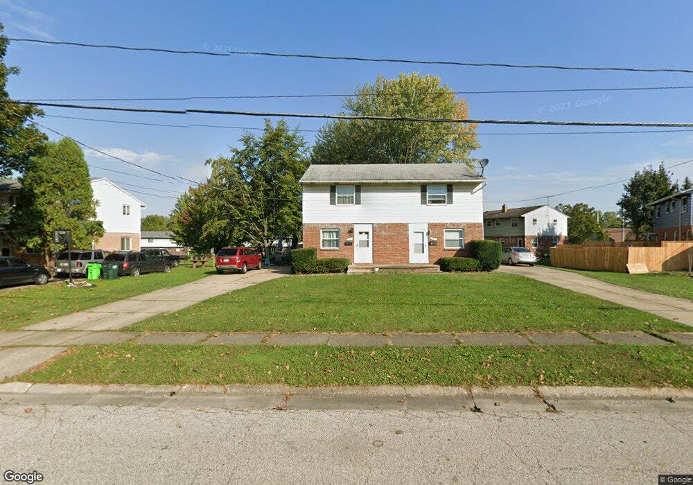
This home is located at 2551 Maplehurst Dr Unit 2555, Stow, OH 44224 and is currently estimated at $233,089, approximately $116 per square foot. 2551 Maplehurst Dr Unit 2555 is a home located in Summit County with nearby schools including Stow-Munroe Falls High School, Primrose School of Hudson, and Holy Family Elementary School.
Ownership History
Date
Name
Owned For
Owner Type
Purchase Details
Closed on
Mar 24, 2020
Sold by
Mariola Michele G and Mariola Maria Anna
Bought by
Fernandez Marc Mas
Current Estimated Value
Home Financials for this Owner
Home Financials are based on the most recent Mortgage that was taken out on this home.
Original Mortgage
$117,826
Interest Rate
3.4%
Mortgage Type
FHA
Create a Home Valuation Report for This Property
The Home Valuation Report is an in-depth analysis detailing your home's value as well as a comparison with similar homes in the area
Home Values in the Area
Average Home Value in this Area
Purchase History
| Date | Buyer | Sale Price | Title Company |
|---|---|---|---|
| Fernandez Marc Mas | $120,000 | None Listed On Document | |
| Fernandez Marc Mas | $120,000 | None Listed On Document |
Source: Public Records
Mortgage History
| Date | Status | Borrower | Loan Amount |
|---|---|---|---|
| Previous Owner | Fernandez Marc Mas | $117,826 |
Source: Public Records
Tax History Compared to Growth
Tax History
| Year | Tax Paid | Tax Assessment Tax Assessment Total Assessment is a certain percentage of the fair market value that is determined by local assessors to be the total taxable value of land and additions on the property. | Land | Improvement |
|---|---|---|---|---|
| 2025 | $3,305 | $57,187 | $14,091 | $43,096 |
| 2024 | $3,305 | $57,187 | $14,091 | $43,096 |
| 2023 | $3,305 | $57,187 | $14,091 | $43,096 |
| 2022 | $2,825 | $42,998 | $10,595 | $32,403 |
| 2021 | $2,538 | $42,998 | $10,595 | $32,403 |
| 2020 | $2,536 | $43,000 | $10,600 | $32,400 |
| 2019 | $2,636 | $41,860 | $10,600 | $31,260 |
| 2018 | $2,595 | $41,860 | $10,600 | $31,260 |
| 2017 | $2,490 | $41,860 | $10,600 | $31,260 |
| 2016 | $2,530 | $38,960 | $10,600 | $28,360 |
| 2015 | $2,490 | $38,960 | $10,600 | $28,360 |
| 2014 | $2,493 | $38,960 | $10,600 | $28,360 |
| 2013 | $2,938 | $46,480 | $10,600 | $35,880 |
Source: Public Records
Map
Nearby Homes
- 4621 Graford Ln
- 2418 Wrens Dr S Unit G
- 4903 Fishcreek Rd Unit 11B
- 4227 Baird Rd
- 4901 Independence Cir Unit B
- 4131 Burton Dr
- 4917 Independence Cir Unit B
- 0 Stow Rd Unit 5102979
- 2380 Port Williams Dr Unit 2380
- 2140 Woodlawn Cir Unit 2144
- 4120 Klein Ave
- 2410 Liberty Rd
- 2755 Laurel Woods Blvd
- 4731 Haughton Ct
- 2327 Crockett Cir
- 3961 Klein Ave
- 0 Vira Rd
- 2140 Uniondale Dr
- 4901 Pebblehurst Dr
- 2028 Willowdale Dr
- 2543 Maplehurst Dr Unit 2547
- 2547 Maplehurst Dr
- 4654 Fishcreek Rd Unit 4658
- 4658 Fishcreek Rd
- 2557 Maplehurst Dr Unit 2561
- 2539 Maplehurst Dr
- 4660 Fishcreek Rd Unit 4664
- 2552 Maplehurst Dr Unit 2556
- 2535 Maplehurst Dr Unit 2539
- 3940 Fishcreek Rd
- 39 Fishcreek Rd
- 0 Fishcreek Rd
- 2556 Maplehurst Dr
- 2528 Maplehurst Dr Unit 2532
- 2531 Maplehurst Dr
- 2562 Maplehurst Dr
- 4423 Cherryhurst Dr Unit 4427
- 2527 Maplehurst Dr Unit 2531
- 4427 Cherryhurst Dr
- 4674 Fishcreek Rd Unit 4678