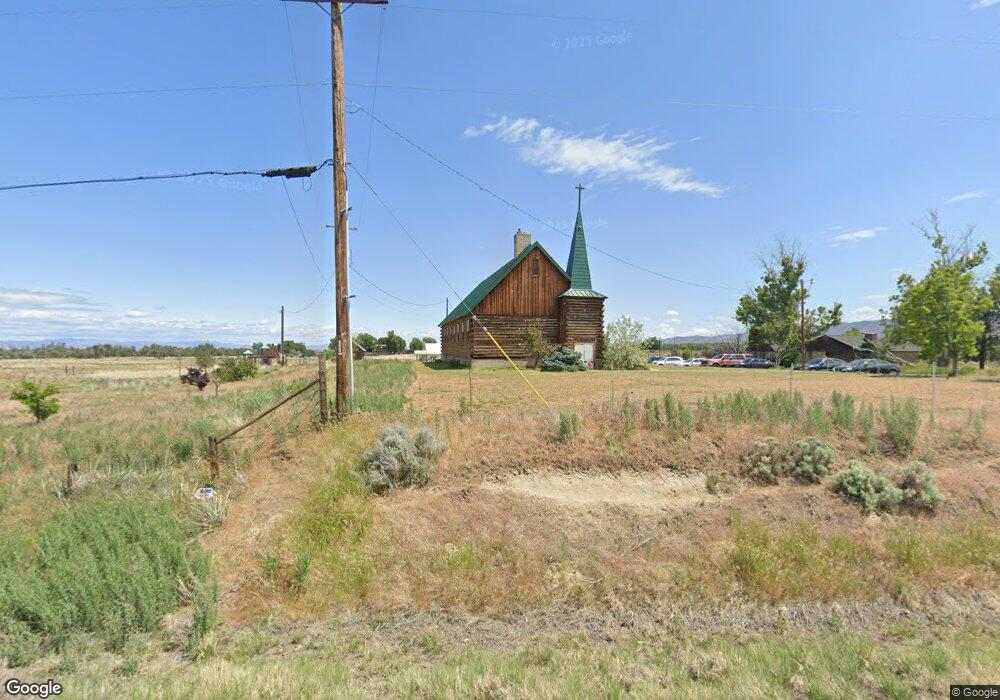
2551 Signal Peak Rd White Swan, WA 98952
Estimated Value: $421,400
4
Beds
1
Bath
5,212
Sq Ft
$81/Sq Ft
Est. Value
About This Home
This home is located at 2551 Signal Peak Rd, White Swan, WA 98952 and is currently priced at $421,400, approximately $80 per square foot. 2551 Signal Peak Rd is a home located in Yakima County with nearby schools including Harrah Elementary School, Mount Adams Middle School, and White Swan High School.
Ownership History
Date
Name
Owned For
Owner Type
Purchase Details
Closed on
Jul 30, 2014
Sold by
Division Of Homeland Ministries Of The C
Bought by
Hubbard James and Hubbard Sharleen
Current Estimated Value
Home Financials for this Owner
Home Financials are based on the most recent Mortgage that was taken out on this home.
Original Mortgage
$99,000
Outstanding Balance
$75,544
Interest Rate
4.13%
Mortgage Type
Commercial
Create a Home Valuation Report for This Property
The Home Valuation Report is an in-depth analysis detailing your home's value as well as a comparison with similar homes in the area
Home Values in the Area
Average Home Value in this Area
Purchase History
| Date | Buyer | Sale Price | Title Company |
|---|---|---|---|
| Hubbard James | $98,000 | Valley Title Guarantee |
Source: Public Records
Mortgage History
| Date | Status | Borrower | Loan Amount |
|---|---|---|---|
| Open | Hubbard James | $99,000 |
Source: Public Records
Tax History Compared to Growth
Tax History
| Year | Tax Paid | Tax Assessment Tax Assessment Total Assessment is a certain percentage of the fair market value that is determined by local assessors to be the total taxable value of land and additions on the property. | Land | Improvement |
|---|---|---|---|---|
| 2025 | $3,703 | $488,950 | $39,150 | $449,800 |
| 2023 | $3,576 | $435,550 | $38,750 | $396,800 |
| 2022 | $3,693 | $421,900 | $29,800 | $392,100 |
| 2021 | $3,572 | $404,000 | $20,000 | $384,000 |
| 2019 | $3,324 | $356,300 | $20,000 | $336,300 |
| 2018 | $3,174 | $330,100 | $20,000 | $310,100 |
| 2017 | $2,769 | $316,000 | $20,000 | $296,000 |
| 2016 | $710 | $289,900 | $20,000 | $269,900 |
| 2015 | $710 | $262,000 | $12,700 | $249,300 |
| 2014 | $710 | $262,000 | $12,700 | $249,300 |
| 2013 | $710 | $262,000 | $12,700 | $249,300 |
Source: Public Records
Map
Nearby Homes
- 403 Curtis St
- 401 Curtis St
- 400 First St
- 331 1st St
- KNA 1st St
- 41 Curtis St
- 31 Curtis St
- 1081 Tecumseh Rd
- NKA Louden Rd
- 0 Louden Rd
- 3500 Island Rd Unit N & S
- 3500 Island Rd Unit South
- 3500 Island Rd Unit North Parcel
- 3500 Island Rd Unit North
- 11334 Pumphouse Rd
- 41 Washington St
- NKA Fort Rd
- 754 Kings Ln
- NKA Jones Riggs Rd
- NKA McDonald Rd